Inverness, California
| Inverness | |
|---|---|
| census-designated place | |
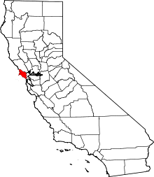
 Location in Marin County and the state of California | |
 Inverness Location in the United States | |
| Coordinates: 38°06′04″N 122°51′25″W / 38.10111°N 122.85694°WCoordinates: 38°06′04″N 122°51′25″W / 38.10111°N 122.85694°W | |
| Country |
|
| State |
|
| County | Marin |
| Government | |
| • County Board |
District 4 Steve Kinsey |
| • State senator | Mike McGuire (D)[1] |
| • Assemblymember | Marc Levine (D)[1] |
| • U. S. rep. | Jared Huffman (D)[2] |
| Area[3] | |
| • Total | 6.835 sq mi (17.704 km2) |
| • Land | 6.399 sq mi (16.574 km2) |
| • Water | 0.436 sq mi (1.130 km2) 6.38% |
| Elevation[4] | 43 ft (13 m) |
| Population (2010) | |
| • Total | 1,304 |
| • Density | 190/sq mi (74/km2) |
| Time zone | PST (UTC-8) |
| • Summer (DST) | PDT (UTC-7) |
| ZIP code | 94937 |
| Area codes | 415/628 |
| FIPS code | 06-36616 |
| GNIS feature ID | 1658827 |
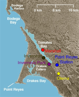
Inverness is an unincorporated community and census-designated place (CDP) located in western Marin County, California. Inverness is located on the southwest shore of Tomales Bay 3.5 miles (5.6 km) northwest of Point Reyes Station,[5] at an elevation of 43 feet (13 m).[4] In the 2010 census, the population was 1,304. The community is named after Inverness in Scotland by a Scots landowner.
Inverness is north of San Francisco, on a bay of the Pacific Ocean.
Community
Inverness is located on the west shore of Tomales Bay, which runs southeast along the line of the San Andreas Fault. Surrounded by Point Reyes National Seashore, it is primarily a residential community, with little industry other than tourism. It has a small downtown area with a general store, post office, library, two restaurants, one gift shop and a coffee shop. A third restaurant is located a short way north of downtown. There are also a number of hotels and inns spread throughout the town.
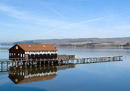
One aspect of the town is a concentration of recreational (and some commercial) boating. There is a small public marina, a few private piers, and the Inverness Yacht Club.
Portions of the John Carpenter film The Fog as well as most of his film Village of the Damned were shot in and around Inverness.
History
The town is 15 miles or so from Drake's Bay on the Pacific Ocean, named after Sir Francis Drake, who explored the coast in the 16th Century. Although Drake's official log was lost, the ship's doctor's log described landing in an area that reminded him of the White Cliffs of Dover. Drake's Bay is backed by similar-looking cliffs, leading many to believe this is where the ship landed.
The region became the property of James Shafter, who began to develop the property in the 1890s. It became a summer resort where people from San Francisco and Oakland came to camp, hike and swim in Tomales Bay. Many built small summer cabins that still exist today. Small steamboats took day trippers down the bay to secluded beaches. They left from Brock Schreiber's boathouse, which has been preserved and is a prominent local landmark with its prominent sign "Launch for Hire".
The first post office opened in 1897.[5]
In 1995, Inverness Ridge was the site of the Mt. Vision Fire, which burned a large area of Point Reyes National Seashore and a number of homes built on the ridge. The town itself was threatened but was saved by helicopters dipping water from Tomales Bay to drop on the Bishop pine forest between the town and the burning ridgetop.
Geography
Inverness is located at 38°06′04″N 122°51′25″W / 38.10111°N 122.85694°W.[4] According to the United States Census Bureau, the CDP has a total area of 6.8 square miles (18 km2), of which, 6.4 square miles (17 km2) of it is land and 0.4 square miles (1.0 km2) of it (6.38%) is water.
The town is adjacent to the San Andreas Fault.
Inverness is spread out along approximately 2 miles (3.2 km) of the western shore and valleys of Tomales Bay on the Point Reyes Peninsula, it provides services to visitors to the Point Reyes National Seashore and Tomales Bay State Park.
Other nearby towns include Point Reyes Station, Inverness Park, Olema, and Marshall.
Climate
This region experiences warm (but not hot) and dry summers, with no average monthly temperatures above 71.6 °F. According to the Köppen Climate Classification system, Inverness has a warm-summer Mediterranean climate, abbreviated "Csb" on climate maps.[6] However the site experiences an extremely narrow range of temperatures, with July being only 4°F warmer than January (54°F versus 50°F). The warmest month is actually September, a pattern common in the San Francisco bay area due to the annual rollover in ocean currents. However note that the nearest NOAA-reporting weather station to Inverness is actually about 10 miles from downtown, at the Point Reyes Lighthouse, in an area with much more sea breeze exposure.
Demographics
2010
The 2010 United States Census[7] reported that Inverness had a population of 1,304. The population density was 190.8 people per square mile (73.7/km²). The racial makeup of Inverness was 1,212 (92.9%) White, 15 (1.2%) African American, 8 (0.6%) Native American, 16 (1.2%) Asian, 2 (0.2%) Pacific Islander, 19 (1.5%) from other races, and 32 (2.5%) from two or more races. Hispanic or Latino of any race were 79 persons (6.1%).
The Census reported that 100% of the population lived in households.
There were 697 households, out of which 90 (12.9%) had children under the age of 18 living in them, 300 (43.0%) were opposite-sex married couples living together, 33 (4.7%) had a female householder with no husband present, 14 (2.0%) had a male householder with no wife present. There were 48 (6.9%) unmarried opposite-sex partnerships, and 9 (1.3%) same-sex married couples or partnerships. 278 households (39.9%) were made up of individuals and 109 (15.6%) had someone living alone who was 65 years of age or older. The average household size was 1.87. There were 347 families (49.8% of all households); the average family size was 2.46.
The population was spread out with 139 people (10.7%) under the age of 18, 35 people (2.7%) aged 18 to 24, 226 people (17.3%) aged 25 to 44, 553 people (42.4%) aged 45 to 64, and 351 people (26.9%) who were 65 years of age or older. The median age was 57.3 years. For every 100 females there were 82.9 males. For every 100 females age 18 and over, there were 82.0 males.
There were 1,130 housing units at an average density of 165.3 per square mile (63.8/km²), of which 451 (64.7%) were owner-occupied, and 246 (35.3%) were occupied by renters. The homeowner vacancy rate was 2.2%; the rental vacancy rate was 9.8%. 65.7% of the population lived in owner-occupied housing units and 34.3% lived in rental housing units.
2000
As of the census[8] of 2000, there were 1,421 people, 707 households, and 364 families residing in the CDP. The population density was 237.9 people per square mile 100.1/km²). There were 999 housing units at an average density of 167.3 per square mile (64.6/km²). The racial makeup of the CDP in 2010 was 89.9% non-Hispanic White, 0.8% non-Hispanic Black or African American, 0.4% Native American, 1.2% Asian, 0.2% from other races, and 1.5% from two or more races. 6.1% of the population were Hispanic or Latino of any race.
There were 707 households out of which 16.0% had children under the age of 18 living with them, 41.9% were married couples living together, 5.5% had a female householder with no husband present, and 48.4% were non-families. 37.2% of all households were made up of individuals and 10.0% had someone living alone who was 65 years of age or older. The average household size was 1.98 and the average family size was 2.56.
In the CDP the population was spread out with 14.5% under the age of 18, 2.7% from 18 to 24, 20.3% from 25 to 44, 41.8% from 45 to 64, and 20.8% who were 65 years of age or older. The median age was 51 years. For every 100 females there were 90.5 males. For every 100 females age 18 and over, there were 86.9 males.
The median income for a household in the CDP was $47,500, and the median income for a family was $78,398. Males had a median income of $42,448 versus $37,321 for females. The per capita income for the CDP was $37,340. About 5.5% of families and 10.6% of the population were below the poverty line, including 20.7% of those under age 18 and 3.6% of those age 65 or over.
References
- 1 2 "Statewide Database". Regents of the University of California. Retrieved April 12, 2015.
- ↑ "California's 2nd Congressional District - Representatives & District Map". Civic Impulse, LLC. Retrieved March 8, 2013.
- ↑ "2010 Census U.S. Gazetteer Files – Places – California". United States Census Bureau.
- 1 2 3 U.S. Geological Survey Geographic Names Information System: Inverness, California
- 1 2 Durham, David L. (1998). California's Geographic Names: A Gazetteer of Historic and Modern Names of the State. Clovis, Calif.: Word Dancer Press. p. 645. ISBN 1-884995-14-4.
- ↑
- ↑ "2010 Census Interactive Population Search: CA - Inverness CDP". U.S. Census Bureau. Retrieved July 12, 2014.
- ↑ "American FactFinder". United States Census Bureau. Retrieved 2008-01-31.
External links
- Inverness Library
 Point Reyes National Seashore travel guide from Wikivoyage
- Inverness info at pointreyes.org
| Bodies of water |
|  |
|---|---|---|
| Counties | ||
| Major cities | ||
| Cities and towns 100k–250k | ||
| Cities and towns 50k–99k | ||
| Cities and towns 25k-50k | ||
| Cities and towns 10k–25k |
| |
| Sub-regions | ||