El Cerrito, California
| El Cerrito | ||
|---|---|---|
| City | ||
| City of El Cerrito | ||
|
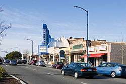
San Pablo Avenue, with the historic Cerrito Theater | ||
| ||
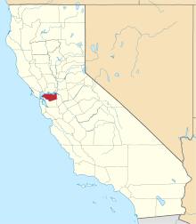
 Location in Contra Costa County and the state of California | ||
 El Cerrito Location in the United States | ||
| Coordinates: 37°54′57″N 122°18′42″W / 37.91583°N 122.31167°WCoordinates: 37°54′57″N 122°18′42″W / 37.91583°N 122.31167°W | ||
| Country |
| |
| State |
| |
| County | Contra Costa | |
| Incorporated | August 23, 1917[1] | |
| Government | ||
| • Mayor | Greg Lyman[2] | |
| • State Senator | Nancy Skinner (D)[3] | |
| • State Assembly | Tony Thurmond (D)[4] | |
| • U. S. Congress | Mark DeSaulnier (D)[5] | |
| • County Board |
District 1: John Gioia | |
| Area[6] | ||
| • Total | 3.688 sq mi (9.551 km2) | |
| • Land | 3.688 sq mi (9.551 km2) | |
| • Water | 0 sq mi (0 km2) 0% | |
| Elevation | 69 ft (21 m) | |
| Population (2010) | ||
| • Total | 23,549 | |
| • Density | 6,400/sq mi (2,500/km2) | |
| Time zone | PST (UTC-8) | |
| • Summer (DST) | PDT (UTC-7) | |
| ZIP code | 94530 | |
| Area code(s) | 510 | |
| GNIS feature IDs | 277504, 2410410 | |
| Website |
www | |

El Cerrito is a city in Contra Costa County, California, United States, and forms part of the San Francisco Bay Area. It has a population of 23,549 according to the 2010 census. El Cerrito was founded by refugees from the 1906 San Francisco earthquake. It was incorporated in 1917 as a village with 1500 residents. As of the census in 2000, there were 23,171 people, 10,208 households and 5971 families in the city. The top 20 employers in the city, according to the 2013 Comprehensive Annual Financial Report, include such entities as the West Contra Costa Unified School District, City of El Cerrito, Lucky Stores, Pastime ACE Hardware, and Honda of El Cerrito.
History
El Cerrito was founded by refugees from the 1906 San Francisco earthquake. They settled in what was then Don Víctor Castro's Rancho San Pablo, and adjacent to the ranch owned by the family of Luís María Peralta, the Rancho San Antonio.[7] A post office opened at the settlement in 1909 and the refugee camp became known as Rust, after Wilhelm F. Rust, its first postmaster.[8][9] The village's residents did not care for the name and changed it to El Cerrito in 1916.[8] A year later, El Cerrito was incorporated as a village with 1,500 residents.[7] The name means "little hill" or knoll.
Geography
According to the United States Census Bureau, the city has a total area of 3.7 square miles (9.6 km2), all of it land. The city is at an elevation of 69 feet (21 m).[9]
El Cerrito is located on the eastern shore of San Francisco Bay. The hilly areas of El Cerrito provide spectacular views of its famous neighbor and the Golden Gate Bridge. El Cerrito is located along Interstate 80, and nearby Interstate 580. The city is less than 30 miles from two major airports. El Cerrito is bordered by Albany and Kensington to the south, the Richmond annex to the west, East Richmond Heights to the north, and Wildcat Canyon Regional Park to the east. Local landmark Albany Hill is in Albany, just across the border with El Cerrito. (El Cerrito—Spanish, "the little hill"—takes its name from Albany Hill.) The Hayward Fault runs through El Cerrito. In addition, El Cerrito is within 150 meters (490 feet) of Berkeley to the southeast.
El Cerrito is approximately 5 miles (8.0 km) from the University of California Berkeley campus and has two BART (Bay Area Rapid Transit) stations: El Cerrito del Norte and El Cerrito Plaza.
 |
East Richmond Heights | | ||
| Richmond | |
Wildcat Canyon Regional Park | ||
| ||||
| | ||||
| Albany | Kensington |
Transportation
The city's primary transportation infrastructure consists of the El Cerrito Plaza and El Cerrito del Norte BART stations, along with several local bus lines operated by AC Transit, providing access to the surrounding area and the nearby cities of Albany, Berkeley and Richmond. In addition to this local service, El Cerrito is also served by AC Transit's transbay buses to the San Francisco Transbay Terminal, as well as its late night service from the del Norte station through Richmond, San Pablo, and Pinole, and one of the All Nighter routes, which follows the Richmond-Millbrae BART line. FAST, Golden Gate Transit, Vallejo Transit, Napa VINE, and WestCat provide feeder service between the del Norte station and elsewhere in Contra Costa County and the North Bay.
Places
San Pablo Avenue stretches the length of El Cerrito and is the primary commercial and retail corridor of the city. El Cerrito is home to El Cerrito Plaza, a large automobile-oriented shopping center originally built as a regional mall in the 1950s, and the Cerrito Theater, a restored two-screen movie theater known for offering beer, wine, and a full dining menu. The shopping center is surrounded by other commercial and retail businesses along San Pablo Avenue and Fairmount Avenue, including Elevation 66 Brewing Company, the original location of Nation's Giant Hamburgers and an ACE Hardware store.
El Cerrito city parks include both recreation/sports parks as well as undeveloped nature areas. Most notable are the 80-acre (320,000 m2) Hillside Natural Area open space, Huber Park (Terrace Drive), Cerrito Vista Park (Moeser Lane and Pomona Avenue), and Arlington Park (Arlington Boulevard), Tassajara Park (Tassajara Avenue and Barrett Avenue), Poinsett Park (Poinsett Avenue), and the Canyon Trail Park and Art Center (Gatto Avenue). The City is home to a 2.6-mile (4.2 km) segment of the Ohlone Greenway (named after the Native American Ohlone people), a trail that runs the length of the City along the BART right-of-way and is popular with walkers, runners, and bicyclists.
The city is home to Arhoolie Records, part of the Smithsonian Institution. Also located in the city is Playland-Not-At-The-Beach, a popular amusement park museum.
Demographics
| Historical population | |||
|---|---|---|---|
| Census | Pop. | %± | |
| 1920 | 1,505 | — | |
| 1930 | 3,870 | 157.1% | |
| 1940 | 6,137 | 58.6% | |
| 1950 | 18,011 | 193.5% | |
| 1960 | 25,437 | 41.2% | |
| 1970 | 25,190 | −1.0% | |
| 1980 | 22,731 | −9.8% | |
| 1990 | 22,869 | 0.6% | |
| 2000 | 23,171 | 1.3% | |
| 2010 | 23,549 | 1.6% | |
| Est. 2015 | 24,954 | [10] | 6.0% |
2010
The 2010 United States Census[12] reported that El Cerrito had a population of 23,549. The population density was 6,385.3 people per square mile (2465.6/km²). The 2010 racial makeup of El Cerrito was:
- 12,543 (53.3%) White,
- 6,439 (27.3%) Asian,
- 1,819 (7.7%) African American,
- 107 (0.5%) Native American,
- 37 (0.2%) Pacific Islander,
- 1,079 (4.6%) from other races, and 1,525 (6.5%) from two or more races.
Hispanic or Latino of any race were 2,621 persons (11.1%).
The Census reported that 23,456 people (99.6% of the population) lived in households, 48 (0.2%) lived in non-institutionalized group quarters, and 45 (0.2%) were institutionalized.
There were 10,142 households, out of which 2,394 (23.6%) had children under the age of 18 living in them, 4,703 (46.4%) were opposite-sex married couples living together, 1,047 (10.3%) had a female householder with no husband present, and 416 (4.1%) had a male householder with no wife present. There were 509 (5.0%) unmarried opposite-sex partnerships, and 189 (1.9%) same-sex married couples or partnerships. 2,953 (29.1%) were made up of individuals and 1188 (11.7%) had someone living alone who was 65 years of age or older. The average household size was 2.31. There were 6,166 families (60.8% of all households); the average family size was 2.84.
The population was spread out with 4,087 people (17.4%) under the age of 18, 1,281 people (5.4%) aged 18 to 24, 6,918 people (29.4%) aged 25 to 44, 7,036 people (29.9%) aged 45 to 64, and 4,227 people (17.9%) who were 65 years of age or older. The median age was 43.5 years. For every 100 females there were 92.3 males. For every 100 females age 18 and over, there were 89.1 males.
There were 10,716 housing units at an average density of 2905.6 per square mile (1122.0/km²), of which 6,145 (60.6%) were owner-occupied, and 3,997 (39.4%) were occupied by renters. The homeowner vacancy rate was 1.1%; the rental vacancy rate was 5.4%. 14,474 people (61.5% of the population) lived in owner-occupied housing units and 8,982 people (38.1%) lived in rental housing units.
2000
As of the census[13] of 2000, there were 23,171 people, 10,208 households, and 5,971 families residing in the city. The population density was 6,356.5 people per square mile (2,451.1/km²). There were 10,462 housing units at an average density of 2,870.1 per square mile (1,106.7/km²). The racial makeup of the city was 57.79% White, 8.54% Black or African American, 0.50% Native American, 24.38% Asian, 0.25% Pacific Islander, 3.06% from other races, and 5.48% from two or more races. 7.93% of the population were Hispanic or Latino of any race.
There were 10,208 households out of which 20.7% had children under the age of 18 living with them, 45.4% were married couples living together, 9.7% had a female householder with no husband present, and 41.5% were non-families. 30.4% of all households were made up of individuals and 12.8% had someone living alone who was 65 years of age or older. The average household size was 2.25 and the average family size was 2.81.
In the city the population was spread out with 15.9% under the age of 18, 6.7% from 18 to 24, 31.2% from 25 to 44, 25.7% from 45 to 64, and 20.4% who were 65 years of age or older. The median age was 43 years. For every 100 females there were 89.7 males. For every 100 females age 18 and over, there were 86.6 males.
The median income for a household in the city was $57,253, and the median income for a family was $69,397 (these figures had risen to $77,650 and $97,488 respectively as of a 2007 estimate[14]). Males had a median income of $50,316 versus $40,866 for females. The per capita income for the city was $32,593. About 3.5% of families and 6.7% of the population were below the poverty line, including 7.9% of those under age 18 and 3.9% of those age 65 or over.
At home the percentages of the languages residents speak are English 70.47%, Spanish 6.26%, Chinese 5.96%, Japanese 2.70%, Mandarin 1.80%, Cantonese 1.57%, Persian 1.43%, Tagalog 1.30%, Korean 1.08%, French 0.90%, German 0.83%, Formosan 0.73%, Italian 0.66%, Vietnamese 0.57%, Urdu 0.50%, and 3.23% of people spoke some other language which represented less than 0.50% of the population.[15]
Economy
Top employers
According to the City of El Cerrito's Comprehensive Annual Financial Report for the year ended June 30, 2013[16] the top employers in the city are:
- Barnes & Noble
- Bed Bath & Beyond
- City of El Cerrito
- CVS Pharmacy
- El Cerrito Royale
- Fat Apple's Restaurant-Bakery
- Home Depot
- Honda of El Cerrito
- Lucky's
- Mira Vista Golf and Country Club
- Nation's Giant Hamburgers
- Pastime Ace Hardware
- Prospect Sierra School
- Romano's Macaroni Grill
- Safeway
- Shields Nursing Center
- Tehiyah Day School
- Trader Joe's
- US Post Office
- West Contra Costa Unified School District
Note: Data not available for ranking or total employees for each employer.
Education
Primary and secondary schools
El Cerrito is in the West Contra Costa Unified School District, a multi-city district that operates three elementary schools, one middle school, and one high school in the city:
- Alvarado Elementary School (closed; currently used for adult education)
- Castro Elementary School (permanently closed; now the site of Fred T. Korematsu Middle School)
- Fairmont Elementary School
- Harding Elementary School
- Madera Elementary School
- Fred T. Korematsu Middle School
- El Cerrito High School
El Cerrito is also home to private elementary and middle schools:
- Keystone Montessori School
- Montessori Community School
- Prospect Sierra School
- St. Jerome Catholic School
- St. John The Baptist
- Tehiyah Day School, a Jewish day school, and a 2012 Blue Ribbon School award winner.[17]
Public libraries
There is a branch of the Contra Costa County Library system in El Cerrito.[18]
Notable people
listed alphabetically by first name
- Adam Sessler, co-host of X-Play on G4.
- Catherine Asaro, science-fiction author, grew up in El Cerrito
- Chris Strachwitz, founder of Arhoolie records
- Dave Mello, drummer of Operation Ivy
- Drew Gooden, Milwaukee Bucks forward, attended El Cerrito High School; during his tenure, basketball team went to and lost state basketball final
- Ernie Broglio, former Major League Baseball player
- Jeff Atwood, co-founder of Stack Overflow
- John C. Dvorak, technology journalist
- John Fogerty, and Tom Fogerty, musicians from the band Creedence Clearwater Revival, grew up in El Cerrito; band reunited to play its last concert during El Cerrito High School reunion at Golden Gate Fields in Albany
- Karen Grassle, actress, Little House on the Prairie, resident of El Cerrito
- Larissa Kelly, all-time female Jeopardy! champion
- Les Blank, documentary filmmaker (born 1935)
- Maria Remenyi, Miss California USA 1966, Miss USA 1966
- Matt Young, former Major League Baseball player
- Paul Baloff, lead vocalist of metal band Exodus
- Pumpsie Green, first African American to play for the Boston Red Sox
- Randy Schekman, winner of 2013 Nobel Prize in Medicine/Physiology
- Robert Culp, film and television actor; buried in El Cerrito
- Susan Rasky, journalist
- Thomas Pridgen, former drummer for the band The Mars Volta, and currently Suicidal Tendencies and Trash Talk
- Tung-Yen Lin, structural engineer who founded T. Y. Lin International
In popular culture
- El Cerrito has been mentioned in the book ttfn by Lauren Myracle. Character Angela finds out the family is moving to El Cerrito.[19]
- El Cerrito is mentioned in the song "Golden Gate Fields" by Rancid
- Metallica wrote Ride the Lightning and Master of Puppets in a small house in El Cerrito where the band lived for a while. Cliff Burton joined the band only if Metallica would agree to move to El Cerrito
- Game Theory's 1988 song "You Drive" mentions El Cerrito in the first line.
- Cracker recorded a song titled "El Cerrito" released on their 2014 album Berkeley to Bakersfield.
Notes
- ↑ "California Cities by Incorporation Date" (Word). California Association of Local Agency Formation Commissions. Retrieved March 27, 2013.
- ↑ "City Council". El Cerrito, CA. Retrieved March 21, 2013.
- ↑ "Senators". State of California. Retrieved March 21, 2013.
- ↑ "Members Assembly". State of California. Retrieved March 21, 2013.
- ↑ "California's 11th Congressional District - Representatives & District Map". Civic Impulse, LLC. Retrieved March 9, 2013.
- ↑ "U.S. Census". Census.gov. Retrieved 2014-01-09.
- 1 2 Contra Costa/Alameda County Line, Mervin Belfils/El Cerrito Historical Society, October 1975/June 2006, retrieved 2007-08-01
- 1 2 Durham, David L. (1998). California's Geographic Names: A Gazetteer of Historic and Modern Names of the State. Clovis, Calif.: Word Dancer Press. p. 628. ISBN 1-884995-14-4.
- 1 2 U.S. Geological Survey Geographic Names Information System: El Cerrito, California
- ↑ "Annual Estimates of the Resident Population for Incorporated Places: April 1, 2010 to July 1, 2015". Retrieved July 2, 2016.
- ↑ "Census of Population and Housing". Census.gov. Retrieved June 4, 2015.
- ↑ "2010 Census Interactive Population Search: CA - El Cerrito city". U.S. Census Bureau. Retrieved July 12, 2014.
- ↑ "American FactFinder". United States Census Bureau. Retrieved 2008-01-31.
- ↑ "American FactFinder". Factfinder.census.gov. Retrieved 2014-01-09.
- ↑ El Cerrito entry, MLA Data Center, retrieved October 21, 2007
- ↑ "City of El Cerrito CAFR". Principal Employers. City of El Cerrito. Retrieved 9 September 2014.
- ↑ "Tehiyah Day School". Tehiyah.org. Retrieved 2014-01-09.
- ↑ "El Cerrito Library." Contra Costa County Library. Retrieved on April 1, 2010.
- ↑ Lauren Myracle (1 February 2007). TTFN (Ta-Ta for Now). Harry N. Abrams. ISBN 978-0-8109-9279-5.
External links
- Official website
- West Contra Costa County School District
- El Cerrito Library
- El Cerrito Art Association
- El Cerrito Chamber of Commerce
- Mira Vista Golf & Country Club
| Bodies of water |
|  |
|---|---|---|
| Counties | ||
| Major cities | ||
| Cities and towns 100k–250k | ||
| Cities and towns 50k–99k | ||
| Cities and towns 25k-50k | ||
| Cities and towns 10k–25k |
| |
| Sub-regions | ||