Martinez, California
| City of Martinez[1] | |
|---|---|
| City | |
|
Aerial view of Martinez | |
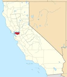
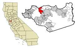 Location in Contra Costa County and the state of California | |
 City of Martinez[4] Location in the United States | |
| Coordinates: 38°01′10″N 122°08′03″W / 38.01944°N 122.13417°WCoordinates: 38°01′10″N 122°08′03″W / 38.01944°N 122.13417°W | |
| Country |
|
| State |
|
| County | Contra Costa |
| Incorporated | April 1, 1876[5] |
| Government | |
| • Mayor | Rob Schroder[6] |
| • State senator | Bill Dodd (D)[7] |
| • Assemblymember | Tim Grayson (D)[8] |
| • United States representatives | Mike Thompson (D) and Mark DeSaulnier (D)[9] |
| Area[10] | |
| • Total | 13.135 sq mi (34.019 km2) |
| • Land | 12.131 sq mi (31.420 km2) |
| • Water | 1.004 sq mi (2.600 km2) 7.64% |
| Elevation[11] | 23 ft (7 m) |
| Population (April 1, 2010)[12] | |
| • Total | 35,824 |
| • Estimate (2013)[12] | 37,165 |
| • Density | 2,700/sq mi (1,100/km2) |
| Time zone | Pacific (UTC-8) |
| • Summer (DST) | PDT (UTC-7) |
| ZIP code | 94553 |
| Area code | 925 |
| FIPS code | 06-46114 |
| GNIS feature IDs | 277553, 2411045 |
| Website | Official website |
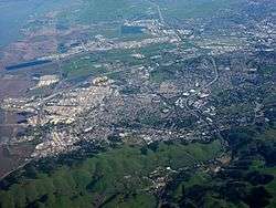
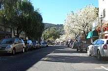
Martinez (/mɑːrˈtiːnᵻs/ mar-TEE-niss or /mɑːrˈtiːnɛθ/ mar-TEE-neth; Spanish: Martínez) is a city and the county seat of Contra Costa County, California, in the East Bay of the San Francisco Bay Area.[13] The population was 35,824 at the 2010 census. The downtown is notable for its large number of preserved old buildings and antique shops. Martinez is located on the south side of the Carquinez Strait in the San Francisco Bay Area, directly facing the cities of Benicia and Vallejo.
History
In 1824 the Alhambra Valley was included in the Rancho El Pinole Mexican land grant to Ygnacio Martínez.[14] In 1847, Dr. Robert Semple contracted to provide ferry service from Martinez to Benicia, which for many years was the only crossing on the Carquinez Strait.[14] By 1849, Martínez served as a way station for the California Gold Rush. The town was laid out in 1849 by Col. William M. Smith and named for Martinez.[15] It became the county seat in 1850, but could not incorporate at the time because it lacked the 200 registered voters required, and only became a city in 1876.[16]
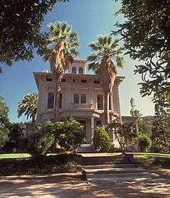
Martinez was the home of naturalist John Muir from 1880 until his death in 1914. He was buried about a mile south of the building that is now the John Muir National Historic Site. Also nearby is the Vicente Martinez Adobe, built in 1849 by the son of Ygnacio Martinez.[16]
The first post office opened in 1851.[15]
In 1860, Martinez played a role in the Pony Express, where riders would take the ferry from Benicia (particularly if they missed the steamer in Sacramento).[17] In 1915, Shell Oil Company built an oil refinery in unincorporated Martinez, which sparked a building boom in the area. A second area refinery[18] (presently owned by Tesoro Petroleum Co.), together with the Shell facilities, help make Martinez a significant petroleum processing center and port. The oil refineries in and near Martinez can still be seen today from Interstate 680.[19]
Folk etymology in Martinez claims the invention of the Martini cocktail and that it is named for the city.[20]
Geography
According to the United States Census Bureau, the city has a total area of 13.1 square miles (34 km2), of which, 12.1 square miles (31 km2) of it is land and 1.0 square mile (2.6 km2) of it (7.64 percent) is water.
Although the common perception of Martinez is that of a refinery town, given the view from Highway 680 across the Shell refinery from the Benicia–Martinez Bridge, the city is in fact largely surrounded by water and regional open space preserves. The Martinez–Benicia Bridge carries Highway 680 across the eastern end of the Carquinez Strait to Solano County. The city can be defined as a more densely built downtown valley threaded by Alhambra creek and north of Highway 4. Suburban areas stretch south of Highway 4 to join the neighboring city of Pleasant Hill. Unincorporated areas include the rural Alhambra Valley and the Franklin Canyon area.
The Martinez Regional Shoreline bounds the city to the north along the Carquinez Strait. Carquinez Strait Regional Shoreline includes the Franklin Hills west of downtown, stretching west to the unincorporated community of Port Costa and the town of Crockett. Briones Regional Park borders the Alhambra Valley to the south. Waterbird Regional Preserve and the McNabney Marsh border the city and Highway 680 to the east. Martinez's location at the east end of the Carquinez Strait as it widens to Suisun Bay includes dramatic water views stretching to the Sierra range. From surrounding ridge tops views stretch to nearby Mt. Diablo, Mt. St. Helena, Mt. Tamalpais, etc.
Martinez is one of the only two places in the Bay Area, the other being Golden Gate Bridge, where the Bay Area Ridge Trail and the San Francisco Bay Trail converge. The Bay Trail is a planned recreational corridor that, when complete, will encircle San Francisco and San Pablo bays with a continuous 400-mile (640 km) network of bicycling and hiking trails. It will connect the shoreline of all nine Bay Area counties, link 47 cities, and cross the major toll bridges in the region, including the Benicia–Martinez Bridge. To date, approximately 240 miles (390 km) of the alignment—over half the Bay Trail's ultimate length—have been completed. The Bay Area Ridge Trail ultimately will be a 500+ mile trail encircling the San Francisco Bay along the ridge tops, open to hikers, equestrians, mountain bicyclists, and outdoor enthusiasts of all types. So far, over 300 miles (480 km) of trail have been dedicated for use. East Bay Regional Park District's Iron Horse Regional Trail will join the Bay Trail along the waterfront, and the Contra Costa Canal Trail threads through the city from Pleasant Hill to the south.
Climate
Martinez has a mild mediterranean climate (Köppen climate classification Csa/b).[21] Summers are warm and dry, with some morning fog during sea breezes. The maritime influence is much less significant than in other parts of the Bay Area that are closer to the Pacific, which causes very high daytime averages compared to San Francisco and Oakland in summer. However, nights normally cool off significantly which results in daytime highs of around 87 °F (31 °C) and night time lows of 55 °F (13 °C) during July and August.[22] Winters are wet and cool with occasional frost. The majority of the city is within a USDA hardiness zone of 9b.
| Climate data for Martinez, California | |||||||||||||
|---|---|---|---|---|---|---|---|---|---|---|---|---|---|
| Month | Jan | Feb | Mar | Apr | May | Jun | Jul | Aug | Sep | Oct | Nov | Dec | Year |
| Average high °F (°C) | 54 (12) |
60 (16) |
64 (18) |
71 (22) |
78 (26) |
84 (29) |
87 (31) |
87 (31) |
83 (28) |
75 (24) |
63 (17) |
55 (13) |
71.8 (22.3) |
| Average low °F (°C) | 39 (4) |
42 (6) |
44 (7) |
46 (8) |
50 (10) |
54 (12) |
55 (13) |
55 (13) |
54 (12) |
49 (9) |
43 (6) |
39 (4) |
47.5 (8.7) |
| Average precipitation inches (mm) | 4.25 (108) |
3.81 (96.8) |
3.24 (82.3) |
1.04 (26.4) |
.46 (11.7) |
.12 (3) |
.02 (0.5) |
.08 (2) |
.24 (6.1) |
.94 (23.9) |
2.61 (66.3) |
2.79 (70.9) |
20.53 (521.5) |
| Source: Weather Channel [23] | |||||||||||||
Demographics
| Historical population | |||
|---|---|---|---|
| Census | Pop. | %± | |
| 1870 | 560 | — | |
| 1890 | 1,609 | — | |
| 1900 | 1,380 | −14.2% | |
| 1910 | 2,115 | 53.3% | |
| 1920 | 3,858 | 82.4% | |
| 1930 | 6,569 | 70.3% | |
| 1940 | 7,381 | 12.4% | |
| 1950 | 8,268 | 12.0% | |
| 1960 | 9,604 | 16.2% | |
| 1970 | 16,506 | 71.9% | |
| 1980 | 22,582 | 36.8% | |
| 1990 | 31,808 | 40.9% | |
| 2000 | 35,866 | 12.8% | |
| 2010 | 35,824 | −0.1% | |
| Est. 2015 | 38,137 | [24] | 6.5% |
.jpg)
2010
The 2010 United States Census[26] reported that Martinez had a population of 35,824. The population density was 2,727.4 people per square mile (1,053.1/km²). The racial makeup of Martinez was 27,603 (77.1%) White, 1,303 (3.6%) African American, 255 (0.7%) Native American, 2,876 (8.0%) Asian, 121 (0.3%) Pacific Islander, 1,425 (4.0%) from other races, and 2,241 (6.3%) from two or more races. Hispanic or Latino of any race were 5,258 persons (14.7 percent).
The Census reported that 34,528 people (96.4 percent of the population) lived in households, 235 (0.7 percent) lived in non-institutionalized group quarters, and 1,061 (3.0 percent) were institutionalized.
There were 14,287 households, out of which 4,273 (29.9 percent) had children under the age of 18 living in them, 6,782 (47.5 percent) were opposite-sex married couples living together, 1,751 (12.3 percent) had a female householder with no husband present, 640 (4.5 percent) had a male householder with no wife present. There were 928 (6.5 percent) unmarried opposite-sex partnerships, and 137 (1.0 percent) same-sex married couples or partnerships. 3,920 households (27.4 percent) were made up of individuals and 1,078 (7.5 percent) had someone living alone who was 65 years of age or older. The average household size was 2.42. There were 9,173 families (64.2 percent of all households); the average family size was 2.95.
The age distribution of the population showed 7,329 people (20.5 percent) under the age of 18, 2,842 people (7.9 percent) aged 18 to 24, 9,193 people (25.7 percent) aged 25 to 44, 12,121 people (33.8 percent) aged 45 to 64, and 4,339 people (12.1 percent) who were 65 years of age or older. The median age was 42.2 years. For every 100 females there were 96.9 males. For every 100 females age 18 and over, there were 94.8 males.
There were 14,976 housing units at an average density of 1,140.2 per square mile (440.2/km²), of which 9,619 (67.3 percent) were owner-occupied, and 4,668 (32.7 percent) were occupied by renters. The homeowner vacancy rate was 1.4 percent; the rental vacancy rate was 4.9 percent. 23,876 people (66.6 percent of the population) lived in owner-occupied housing units and 10,652 people (29.7 percent) lived in rental housing units.
|
2000
As of the census[28] of 2000, there were 35,866 people, 14,300 households, and 9,209 families residing in the city. The population density was 2,927.6 people per square mile (1,130.4/km²). There were 14,597 housing units at an average density of 1,191.5/sq mi (460.1/km²). The racial makeup of the city was 81.03 percent White, 3.35 percent Black or African American, 0.74 percent Native American, 6.63 percent Asian, 0.23 percent Pacific Islander, 3.29 percent from other races, and 4.72 percent from two or more races. 10.20 percent of the population were Hispanic or Latino of any race. 11.7 percent were of German, 10.8 percent Irish, 10.2 percent Italian, 9.4 percent English and 5.4 percent American ancestry.
There were 14,300 households out of which 30.0 percent had children under the age of 18 living with them, 49.4 percent were married couples living together, 11.0 percent had a female householder with no husband present, and 35.6 percent were non-families. 27.4 percent of all households were made up of individuals and 6.9 percent had someone living alone who was 65 years of age or older. The average household size was 2.41 and the average family size was 2.96.
In the city the age distribution of the population showed 22.7 percent under the age of 18, 7.3 percent from 18 to 24, 32.6 percent from 25 to 44, 27.3 percent from 45 to 64, and 10.1 percent who were 65 years of age or older. The median age was 39 years. For every 100 females there were 98.5 males. For every 100 females age 18 and over, there were 96.0 males.
The median income for a household in the city was $63,010, and the median income for a family was $77,411 (these figures had risen to $73,668 and $92,486 respectively as of a 2007 estimate).[29] Males had a median income of $52,135 versus $40,714 for females. The per capita income for the city was $29,701. About 3.2 percent of families and 5.2 percent of the population were below the poverty line, including 3.9 percent of those under age 18 and 4.8 percent of those age 65 or over.
The languages spoken were 88 percent English, 6 percent Spanish, 2 percent Tagalog, 1 percent German, 1 percent Chinese, 0.5 percent Italian, 0.5 percent Persian, 0.3 percent Korean, 0.3 percent Portuguese, 0.3 percent Russian, 0.3 percent Arabic, 0.2 percent Dutch, 0.2 percent Polish, 0.2 percent French, 0.2 percent Punjabi, 0.2 percent Vietnamese, 0.1 percent Japanese, 0.1 percent Tamil, 0.1 percent Cantonese. Of the 4,176 people who did not use English as their primary language 3,663 (87.7 percent) spoke it well or very well while 513 (12.3 percent) spoke it "not well" or "not at all"[30]
Economy
Top employers
According to the City's 2009 Comprehensive Annual Financial Report,[32] the top employers in the city are:
| # | Employer | # of Employees |
|---|---|---|
| 1 | Contra Costa County | 9,847 |
| 2 | Shell Oil Company | 742 |
| 3 | Kaiser Permanente | 722 |
| 4 | Veterans Health Administration | 650 |
| 5 | Martinez Unified School District | 380 |
| 6 | Wal-Mart | 234 |
| 7 | Safeway | 174 |
| 8 | Contra Costa Electric | 150 |
| 9 | City of Martinez | 127 |
| 10 | The Home Depot | 120 |
Sister cities
According to Sister Cities International, Martinez is paired with Dunbar in Scotland, Hanchuan in China, and the Italian towns of Milazzo and Stresa.
Transportation
Rail
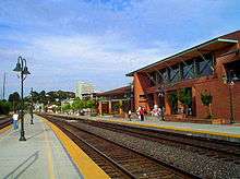
- Amtrak, the national passenger rail system, runs its California Zephyr daily in each direction through Martinez on its route between Emeryville (across the bay from San Francisco) and Chicago, also passing through Sacramento, Reno, Salt Lake City, Denver, and Omaha.
- Amtrak's Coast Starlight operates daily in each direction through Martinez between Seattle and Los Angeles.
- Amtrak California operates its Capitol Corridor trains through Martinez station, providing service several times daily between San Jose to the west and Auburn to the east (via Sacramento).
- Amtrak California also runs its San Joaquin trains through Martinez, providing service several times daily between Oakland to the west and Bakersfield at the south end of the San Joaquin Valley. Bus connections branch off both the San Joaquin and the Capitol Corridor, providing service as far as San Diego; Las Vegas and Sparks, Nevada; and Medford, Oregon. One connection originates in Martinez and runs as far north as the Eureka area.
- BART makes a stop at a station called North Concord/Martinez, although this station lies miles east of the city limits. The city was overlooked when the system was extended from Concord to Bay Point. However BART's long term plans include a new line extension running from Fremont and through the I-680 corridor and ending in Martinez.
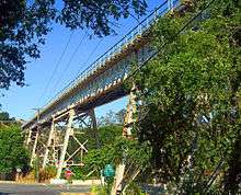
- The 1,680-foot (512.06 m)-long, 80-foot (24.38 m) high steel "Muir Trestle" (aka "Alhambra Trestle") carries the freight operations of the BNSF Railroad through Martinez parallel to California State Route 4 (John Muir Parkway).
Bus
- WestCAT provides service to El Cerrito del Norte BART Station.
- The County Connection is the primary local bus operator providing service throughout the area. Among its destinations are the Concord, Pleasant Hill, and Walnut Creek BART stations. The County Connection also provides paratransit service.
- Tri-Delta Transit runs express service between Martinez and eastern Contra Costa County.
Major highways
- State Route 4 runs through Martinez westward to Hercules and eastward through Stockton and the Sierra Nevada to near the border of Nevada.
- Interstate 680 runs northward across the Benicia–Martinez Bridge toward Sacramento via Interstate 80 and southward toward San Jose.
Media
The city of Martinez is served by the newspaper Martinez News Gazette, the daily newspaper, Contra Costa Times published by Bay Area News Group-East Bay (part of the Media News Group, Denver, Colorado), and by the Martinez Tribune.
Martinez is also served by Martinez Patch, a local news website covering community news and events. Patch Media is owned by AOL Inc. The local news and talk blog serving Martinez is Claycord.com.
Education
Covering most of Martinez, the Martinez Unified School District encompasses four elementary schools, one middle school, one high school, and two alternative/independent study schools. Students in K-5 attend John Swett, John Muir, Las Juntas, or Morello Park Elementary School. Martinez Junior High School serves students in grades 6 through 8. St. Catherine of Siena is a private Catholic school that serves grades K-8. Alhambra High School serves as the districts' comprehensive high school. As of 2006, the districts' K-12 enrollment was 4,194. Part of Martinez is served by the Mount Diablo Unified School District, whose Hidden Valley Elementary School is located in Martinez. St. Catherine of Siena School (Martinez, California), a private Roman Catholic elementary, also serves the Martinez community.
Public libraries
The Martinez Library of the Contra Costa County Library is located in Martinez and is locally registered as a landmark for architectural considerations.[33] The Art Deco Martinez Library was also placed on the National Register of Historic Places in early 2008.
Beavers
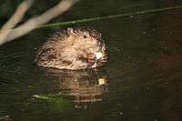 Beaver kits nibbling some food
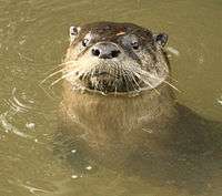 River otter returns to beaver pond in 2008
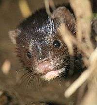 Mink returns to beaver pond in 2009
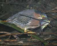 Green heron eating first recorded Tule perch in Alhambra Creek
In early 2007, a group of beavers settled in a section of Alhambra Creek that flows through the city.[34] The beavers and their dam became a local attraction. Because the 6-foot-high (1.8 m), 30-foot-wide (9.1 m) dam created a potential flood hazard, local officials proposed to remove the beavers. Increased run-off from developed areas along the creek has increased flooding in Martinez, a low-lying city built on a flood plain, in recent decades. Although Martinez had completed the construction of a $9.7 million flood control project in 1999, the downtown was flooded in 2005, ironically two years before the beavers arrived. A City Council subcommittee was formed to consider whether the beavers could be protected and flood risk managed, and was given 90 days to issue a report to the full council for a vote.[35] During this period, expert Skip Lisle was hired to install a flow device that could reduce the level of impounded water behind the beaver dam and mitigate flooding risk above the beaver dam.[36] The beavers have received national attention, amateur video coverage, a webpage devoted to them, and a new nonprofit organization ("Worth A Dam") formed.[37] The beaver have transformed Alhambra Creek from a trickle into multiple dams and beaver ponds, which in turn, led to the return of steelhead (Oncorhynchus mykiss) and river otter (Lontra canadensis) in 2008, and mink (Neovison vison) in 2009.[38][39] The beaver parents have produced babies every year since their 2006 arrival.[40] However, in June 2010, after birthing and successfully weaning triplets this year (and quadruplets the previous three years), "Mom Beaver" died of natural causes.[41]
The Martinez beavers probably originated from the Sacramento-San Joaquin River Delta. Historically, before the California Fur Rush of the late eighteenth and early nineteenth centuries, the Delta probably held the largest concentration of beaver in North America. It was California's early fur trade, more than any other single factor, that opened up the West, and the San Francisco Bay Area in particular, to world trade. In 1840, explorer Captain Thomas Farnham wrote that "There is probably no spot of equal extent in the whole continent of America which contains so many of these much sought animals."[42]
Notable people
- Maurice Benard, actor, known for playing Sonny Corinthos on General Hospital
- Yau-Man Chan, reality television star: Survivor Fiji
- Sara Del Rey, professional wrestler
- Joe DiMaggio, Hall of Fame baseball player for New York Yankees, was born in Martinez in 1914
- Vince DiMaggio, All-Star baseball outfielder, older brother of Joe DiMaggio
- Robb Flynn, Machine Head frontman
- Ella Leffland, born Martinez 1931, author, The Knight, Death and The Devil (National Book Award winner), Rumors of Peace based on living in Martinez (called Mendoza) in World War II
- Norman Francis McFarland, Roman Catholic bishop
- Tug McGraw, Major League Baseball pitcher, father of singer Tim McGraw
- John Muir, naturalist
- Aldo Ray, actor, lived in Crockett in Contra Costa County, died in Martinez in 1991
- Richard Rodgers, tight end for the Green Bay Packers
- Sabato "Simon" Rodia, creator of giant folk art Watts Towers in Los Angeles, spent last ten years of his life in Martinez
- Victor Salva, film director
- Robert Stephenson, Professional baseball player
- Norv Turner, NFL head coach, and brother Ron, assistant coach for Chicago Bears, grew up in Martinez
- Jeff Van Gundy, NBA coach and TV commentator, and brother Stan Van Gundy, coach of Detroit Pistons, were raised in Martinez
- Tom Walsh, NFL offensive coordinator and wide receivers coach for Los Angeles and Oakland Raiders,grew up in Martinez (Alhambra Valley)
- Travis Williams, kick returner for the Green Bay Packers
- Trevor Davis, wide receiver for the Green Bay Packers
- Raul Rekow, Conga Drummer & Percussionist for Santana 1976-2014 ~ Died 2015
See also
 |
Port Costa | Benicia | Suisun Bay | |
| Hercules | |
Pacheco | ||
| ||||
| | ||||
| Pinole Richmond |
Lafayette | Pleasant Hill |
References
- ↑ "Homepage". City of Martinez. Retrieved November 20, 2014.
- ↑ "Homepage". City of Martinez. Retrieved November 20, 2014.
- ↑ "Homepage". City of Martinez. Retrieved November 20, 2014.
- ↑ "Homepage". City of Martinez. Retrieved November 20, 2014.
- ↑ "California Cities by Incorporation Date" (Word). California Association of Local Agency Formation Commissions. Retrieved March 27, 2013.
- ↑ "Mayor and City Council". City of Martinez. Retrieved March 21, 2013.
- ↑ "Senators". State of California. Retrieved March 21, 2013.
- ↑ "Members Assembly". State of California. Retrieved March 21, 2013.
- ↑ "California's 11th Congressional District - Representatives & District Map". Civic Impulse, LLC. Retrieved September 28, 2014.
- ↑ "2010 Census U.S. Gazetteer Files – Places – California". United States Census Bureau.
- ↑ "Martinez". Geographic Names Information System. United States Geological Survey. Retrieved January 21, 2015.
- 1 2 "Martinez (city) QuickFacts". United States Census Bureau. Retrieved April 12, 2015.
- ↑ "Find a County". National Association of Counties. Archived from the original on May 31, 2011. Retrieved June 7, 2011.
- 1 2 "Martinez Historical Society". Martinezhistory.org. Archived from the original on June 13, 2013. Retrieved July 14, 2013.
- 1 2 Durham, David L. (1998). California's Geographic Names: A Gazetteer of Historic and Modern Names of the State. Clovis, Calif.: Word Dancer Press. p. 660. ISBN 1-884995-14-4.
- 1 2 Martinez, CA, City History Archived August 2, 2015, at the Wayback Machine.
- ↑ "Martinez History and the Pony Express". Martinezhistory.org. Archived from the original on June 13, 2013. Retrieved July 14, 2013.
- ↑ "California Refinery". Arb.ca.gov. Retrieved July 14, 2013.
- ↑ "Welcome to Shell Martinez Refinery". shell.us. Shell Oil Company. Retrieved July 14, 2013.
- ↑ "The Martini Story". cityofmartinez.org. City of Martinez. Retrieved July 14, 2013.
- ↑ "Martinez, California Climate Summary". Weatherbase. Retrieved March 6, 2015.
- ↑ "Martinez, California Temperature Averages". Weatherbase. Retrieved March 6, 2015.
- ↑ Average weather for Martinez Weather Channel Retrieved March 30, 2008
- ↑ "Annual Estimates of the Resident Population for Incorporated Places: April 1, 2010 to July 1, 2015". Retrieved July 2, 2016.
- ↑ "Census of Population and Housing". Census.gov. Archived from the original on May 11, 2015. Retrieved June 4, 2015.
- ↑ "2010 Census Interactive Population Search: CA – Martinez city". U.S. Census Bureau. Retrieved July 12, 2014.
- ↑ "Demographic Profile Bay Area Census". bayareacensus.ca.gov.
- ↑ "American FactFinder". United States Census Bureau. Archived from the original on September 11, 2013. Retrieved January 31, 2008.
- ↑ Martinez, California, US Census Bureau
- ↑ MLA Data Center, Martínez, California entry, U.S. Census Dept. (Census 2000), retrieved January 17, 2008
- ↑ Farm Report: Contra Costa wines "After Prohibition was repealed, wineries began to open again in Contra Costa County, including J.E. Digardi Winery, Viano Vineyards and the J. Gonsalves Winery. Viano Vineyards has been making wine at their family winery ever since.
- ↑ "City of Martinez CAFR". Retrieved July 14, 2013.
- ↑ "Martinez Library." Contra Costa County Library. Retrieved on April 1, 2010.
- ↑ Jason B. Johnson (May 21, 2007). "Martinez Beavers set up shop downtown:Mayor says they've become city's most popular attraction". San Francisco Chronicle. Retrieved November 22, 2009.
- ↑ "Martinez Beaver Dam Safe Despite Rough Storms". CBS News. January 4, 2008. Archived from the original on January 8, 2008.
- ↑ "Telluride Leaves It to Beaver". United States Golf Association. January–February 2005. Archived from the original on February 8, 2005.
- ↑ "Martinez Beavers". martinezbeavers.org. Retrieved April 1, 2016.
- ↑ Aleta George (2008). "Martinez Beavers". Bay Nature. Bay Nature Institute. Retrieved November 6, 2009.
- ↑ Nicola DeRobertis-Theye. "Beavers and More in Martinez:New Habitat Thanks to Beavers". Bay Nature. Bay Nature Institute. Retrieved November 6, 2009.
- ↑ Carolyn Jones (June 11, 2010). "New baby beaver has Martinez residents beaming". San Francisco Chronicle. Retrieved June 12, 2010.
- ↑ Joe Eaton (July 5, 2010). "Wild Neighbors: A Death in the Family". The Berkeley Daily Planet. Retrieved July 6, 2010.
- ↑ Thomas Jefferson Farnham (1857). Life, adventures, and travels in California. Blakeman & Co. p. 383. Retrieved April 1, 2016.
External links
- Official website
- U.S. Geological Survey Geographic Names Information System: Martinez, California
- Martinez Area Chamber of Commerce
- Main Street Martinez
- Martinez, California Scenes, c.1927. Silent amateur film of daily life
- Worth a Dam the nonprofit that saved the Martinez beavers
| Bodies of water |
|  |
|---|---|---|
| Counties | ||
| Major cities | ||
| Cities and towns 100k–250k | ||
| Cities and towns 50k–99k | ||
| Cities and towns 25k-50k | ||
| Cities and towns 10k–25k |
| |
| Sub-regions | ||