Pacifica, California
| City of Pacifica | ||
|---|---|---|
| City | ||
|
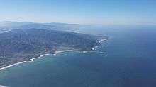
Aerial view of Pacifica | ||
| ||
 Location in San Mateo County and the state of California | ||
 City of Pacifica Location in the United States | ||
| Coordinates: 37°37′22″N 122°29′8″W / 37.62278°N 122.48556°WCoordinates: 37°37′22″N 122°29′8″W / 37.62278°N 122.48556°W | ||
| Country |
| |
| State |
| |
| County | San Mateo | |
| Incorporated | November 22, 1957[1] | |
| Government | ||
| • Mayor | Sue Digre | |
| • Mayor Pro Tempor | Mike O'Neill | |
| Area[2] | ||
| • Total | 12.660 sq mi (32.789 km2) | |
| • Land | 12.658 sq mi (32.784 km2) | |
| • Water | 0.002 sq mi (0.005 km2) 0.01% | |
| Elevation[3] | 82 ft (25 m) | |
| Population (2010) | ||
| • Total | 37,234 | |
| • Density | 2,900/sq mi (1,100/km2) | |
| Time zone | Pacific (UTC-8) | |
| • Summer (DST) | PDT (UTC-7) | |
| ZIP codes | 94044, 94045 | |
| Area code | 650 | |
| FIPS code | 06-54806 | |
| GNIS feature IDs | 277613, 2411351 | |
| Website |
www | |

Pacifica is a city in San Mateo County, California, on the coast of the Pacific Ocean between San Francisco and Half Moon Bay.
Overview
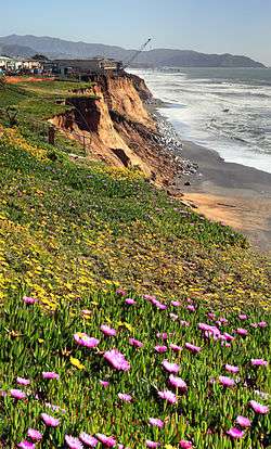
The City of Pacifica is spread along a six-mile (9.7-kilometre) stretch of coastal beaches and hills in north central California. The city comprises several small valleys spread between Sweeney Ridge in the east, Montara Mountain to the south, and the Pacific Ocean's rocky bluffs to the west.
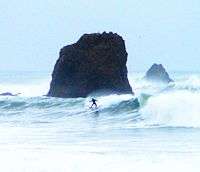
Pacifica is well known regionally as a popular surfing destination. Surfers and families often visit Linda Mar Beach. Rockaway Beach is a scenic location and offers recreation, shopping and dining. 2005 marked the opening of the top ranked Pacifica Skateboard Park. Pacifica is also a popular mountain biking destination, with many trails crossing the hillsides that surround the city, including Pedro Mountain Road, Sweeney Ridge, and areas of the Golden Gate National Recreation Area. Fishermen frequent the local beaches and the Pacifica Pier, often catching Striped Bass and Salmon. Pacifica is also a popular place to hike, with many trails that wind along the beaches and bluffs, including Mori Point, San Pedro Valley County Park,[4] the Sanchez Adobe, Milagra Ridge, and the privately owned Pacifica quarry. For live local theater and performing arts, Pacifica Spindrift Players is a local and popular favorite, in addition to Pacifica Performances which regularly provides both musical presentations and performing arts as well. Pacifica is also home to the Sharp Park Golf Course,[5] which was designed in 1931 by architect Alister MacKenzie. The world class bromeliad nursery, Shelldance Orchid Gardens is located just off Highway 1 in Pacifica, adjacent to the Sweeney Ridge hiking trailhead.
Neighborhoods
Pacifica is divided into roughly twelve distinct neighborhoods from north to south:

- Fairmont
- Westview (Pacific Highlands)
- Pacific Manor (Manor)
- Edgemar
- Sharp Park
- Fairway Park
- Vallemar
- Rockaway Beach
- Pedro Point and Shelter Cove in the south west,
- Linda Mar, Linda Mar Valley, (formerly Pedro Valley or San Pedro Valley) in the south.
- Park Pacifica in south east portions of the city (called the Back of the Valley).
Demographics
| Historical population | |||
|---|---|---|---|
| Census | Pop. | %± | |
| 1960 | 20,995 | — | |
| 1970 | 36,020 | 71.6% | |
| 1980 | 36,866 | 2.3% | |
| 1990 | 37,670 | 2.2% | |
| 2000 | 38,390 | 1.9% | |
| 2010 | 37,234 | −3.0% | |
| Est. 2015 | 39,260 | [6] | 5.4% |
2010
The 2010 United States Census[8] reported that Pacifica had a population of 37,234. The population density was 2,941.1 people per square mile (1,135.6/km²). The racial makeup of Pacifica was 55.6% white, 16.8% (6,243) Hispanic or Latino of any race, 976 (2.6%) African American, 206 (0.6%) Native American, 7,230 (19.4%) Asian, 315 (0.8%) Pacific Islander, 1,703 (4.6%) from other races, and 2,638 (7.1%) from two or more races.
The Census reported that 37,052 people (99.5% of the population) lived in households, 64 (0.2%) lived in non-institutionalized group quarters, and 118 (0.3%) were institutionalized.
There were 13,967 households, out of which 4,511 (32.3%) had children under the age of 18 living in them, 7,385 (52.9%) were opposite-sex married couples living together, 1,592 (11.4%) had a female householder with no husband present, 709 (5.1%) had a male householder with no wife present. There were 869 (6.2%) unmarried opposite-sex partnerships, and 237 (1.7%) same-sex married couples or partnerships. 3,126 households (22.4%) were made up of individuals and 1,098 (7.9%) had someone living alone who was 65 years of age or older. The average household size was 2.65. There were 9,686 families (69.3% of all households); the average family size was 3.12.
The population was spread out with 7,707 people (20.7%) under the age of 18, 2,842 people (7.6%) aged 18 to 24, 10,011 people (26.9%) aged 25 to 44, 12,155 people (32.6%) aged 45 to 64, and 4,519 people (12.1%) who were 65 years of age or older. The median age was 41.5 years. For every 100 females there were 95.6 males. For every 100 females age 18 and over, there were 93.4 males.
There were 14,523 housing units at an average density of 1,147.2 per square mile (442.9/km²), of which 9,545 (68.3%) were owner-occupied, and 4,422 (31.7%) were occupied by renters. The homeowner vacancy rate was 0.9%; the rental vacancy rate was 4.8%. 26,567 people (71.4% of the population) lived in owner-occupied housing units and 10,485 people (28.2%) lived in rental housing units.
|
2000
As of the census[10] of 2000, there were 38,390 people, 13,994 households, and 9,655 families residing in the city. The population density was 3,038.9 people per square mile (1,173.6/km²). There were 14,245 housing units at an average density of 1,127.6 per square mile (435.5/km²).
There were 13,994 households out of which 32.0% had children under the age of 18 living with them, 53.5% were married couples living together, 11.0% had a female householder with no husband present, and 31.0% were non-families. 21.2% of all households were made up of individuals and 6.4% had someone living alone who was 65 years of age or older. The average household size was 2.73 and the average family size was 3.21.
In the city, the population was spread out with 23.2% under the age of 18, 7.7% from 18 to 24, 32.8% from 25 to 44, 26.6% from 45 to 64, and 9.7% who were 65 years of age or older. The median age was 38 years. For every 100 females there were 97.2 males. For every 100 females age 18 and over, there were 95.2 males.
The median income for a household in the city was $31,737, and the median income for a family was $48,361 (these figures had risen to $52,000 and $62,463 respectively as of a 2007 estimate[11]). Males had a median income of $50,761 versus $40,261 for females. The per capita income for the city was $30,183. About 1.2% of families and 2.9% of the population were below the poverty line, including 1.2% of those under age 18 and 4.9% of those age 65 or over.
The oldest person to ever live in Pacifica is Rose G. Rosenthal who was born on April 8, 1901, and died December 27, 2008.
The Reverend Herschell Harkins Memorial pier was constructed in 1973 and was designed to carry sewage piping out to sea. It was closed in 1992 due to corrosion of some of the structure. Since then the pier has been repaired and is a well known fishing spot; on July 8–9, 1995, over 1,000 salmon were caught from the pier.
Economy
Top employers
According to the City's 2015 Comprehensive Annual Financial Report,[12] the top employers in the city are:
| # | Employer | # of Employees |
|---|---|---|
| 1 | Pacifica School District | 349 |
| 2 | Safeway | 227 |
| 3 | City of Pacifica | 225 |
| 4 | Jefferson Union High School District | 90 |
| 5 | Recology of the Coast | 49 |
| 6 | Rite Aid | 42 |
| 7 | Ross | 30 |
| 8 | North Coast County Water District | 20 |
Geography
Topography
Pacifica straddles San Pedro Creek which flows from the western slope of Sweeney Ridge. The far eastern portion of Pacifica includes San Andreas Creek which flows down the eastern slope of Sweeney Ridge. The Portola expedition followed these two creeks in the discovery of San Francisco Bay. Calera Creek runs through Pacifica Quarry and is protected as ESHA Environmentally Sensitive Habitat.
Climate
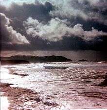
Pacifica has a cool summer Mediterranean climate (Köppen climate classification Csb) typical of coastal areas of California.[13] The National Weather Service has maintained a cooperative weather station in Pacifica since November 1, 1983. Based on those records, average January temperatures range from 45.8 °F (7.7 °C) to 56.7 °F (13.7 °C) and average September temperatures range from 53.9 °F (12.2 °C) to 71.8 °F (22.1 °C). There are an average of 3.0 days with highs of 90 °F (32 °C) or higher and an average of 0.2 day with lows of 32 °F (0 °C) or lower. The highest temperature on record was 102 °F (39 °C) on October 5, 1987, and the lowest temperature was 23 °F (−5 °C) on December 22, 1990. Annual precipitation averages 30.29 inches (769 mm) and has ranged from 15.88 inches (403 mm) in 1990 to 43.17 inches (1,097 mm) in 1996. The most rainfall in one month was 18.05 inches (458 mm) in February 1998 and the most rainfall in 24 hours was 5.00 inches (127 mm) on December 27, 2004. There are an average of 66 days annually with measurable precipitation, most of which falls from October through May. Summer fogs often produce light drizzle in the night and morning hours. Condensation from the fogs also produces fog drip from trees overnight. No measurable snowfall has been recorded since records began.[14] The southeastern portions of the municipality, such as Park Pacifica, are known to be much sunnier than the rest of the city. [15]
Government
Governed by a city council of five elected members, with each council seat in turn serving as mayor for a one-year term. A City Manager, City Attorney and City Clerk are appointed and serve in support of the Council to enact the ordinances passed by the Council, which meets biweekly on the second and fourth Mondays of the month.[16]
Departments
The major City departments, ranked by cost:[17]
- 32% - Police and Communication Services
- 23% - Fire and Emergency Services
- 6% - Development and Engineering
- 6% - Childcare programs
- 5% - City Attorney
- 5% - Public Works
- 5% - Parks, Beach & Recreation
- 5% - Finance and MIS
As of August 1, 2011, the South San Francisco Police Department took over the Pacifica emergency calls dispatch.[18]
State and federal representation
In the California State Legislature, Pacifica is in the 13th Senate District, represented by Democrat Jerry Hill, and in the 22nd Assembly District, represented by Democrat Kevin Mullin.[19]
In the United States House of Representatives, Pacifica is in California's 14th congressional district, represented by Democrat Jackie Speier.[20]
Media
The local newspaper, the Pacifica Tribune,[21] is published every Wednesday. It originated as the Coastside Tribune early in the twentieth century. The Tribune is locally owned by Sherman Frederick who publishes 13 weekly newspapers in Pacifica, Marin County and Nevada.
Other media include:
- The San Mateo Daily Journal, http://www.smdailyjournal.com/
- Pacifica.city, http://www.pacifica.city/
- The Coastsider, http://coastsider.com/
- Pacifica Magazine published by the award winning Half Moon Bay Review, http://www.hmbreview.com/app/pacifica_magazine/
- Pacificariptide, http://www.pacificariptide.com
- Peninsula Press - a project of Stanford_journalism, http://peninsulapress.com/
Pacifica Community Television, Pacifica's Emmy Award-winning local Public-access television cable TV channel 26, has continuously operated for 30 years featuring community based television.
History
Before European settlers arrived, Pacifica was home to two significant Ohlone Indian villages: Pruristac located at San Pedro Creek near present-day Adobe Drive, and Timigtac on Calera Creek in the Rockaway Beach neighborhood.
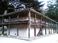
Pacifica is the location of the oldest European discovery of the San Francisco Bay. An expedition led by Gaspar de Portolà sighted the bay by climbing the hills of Sweeney Ridge in Pacifica on October 31, 1769.[22] Before then, earlier Spanish maritime explorers of the California coast (such as Juan Cabrillo and Sebastian Vizcaino) had missed the San Francisco Bay because heavy fog so frequently shrouded the entrance of the San Francisco Bay into the Pacific Ocean (the Golden Gate). Sighting the San Francisco Bay accelerated the Spanish colonization of Alta California because it was the only large, safe, centrally located harbor on the Alta California coast. The Spanish had used Monterey Bay up until then as their main harbor, but it was much more dangerous than San Francisco Bay. In the Spanish era, Pacifica was the site of the San Pedro Valley Mission Outpost (1786–1793) of Mission Dolores. This was dissolved when a newly independent Mexico secularized the mission system. Pacifica is also the site of the still extant Mexican-era Sánchez Adobe built in 1846. The city is located on a part of the Mexican land grant Rancho San Pedro given to Francisco Sanchez in 1839.
Pacifica was incorporated in 1957, relatively recently in the history of San Mateo County, as the union of nine previously separate, unincorporated communities, including Edgemar, Sharp Park, Pacific Manor (or just Manor), Vallemar, Rockaway Beach and San Pedro Terrace-By-The-Sea,[23] stops on the short lived Ocean Shore Railroad. The name "Pacifica" was chosen by vote. A close runner-up was the name "Coastside". In 1960, the city seal was designed by resident Ralph Barkey, who was inspired by Ralph Stackpole's towering "Pacifica" statue produced for the 1939–1940 Golden Gate International Exposition on Treasure Island in the San Francisco Bay.[24]
Education
Primary and secondary schools
The public elementary and middle school district, known as Pacifica School District, (formerly the Laguna Salada School District), consists of Vallemar, Cabrillo, Ingrid B. Lacy, Sunset Ridge, Ortega, Linda Mar and Ocean Shore schools, and also a home schooling program. The administration office is located at 375 Reina del Mar Avenue, adjacent to Vallemar School. Each school enrolls about 550-600 students. There are two private K-8 schools, Good Shepherd School and Alma Heights Christian Academy.
Pacifica has one private high school and two public high schools which are part of the Jefferson Union High School District. Oceana High School in the central part of the city while Terra Nova High School and Alma Heights Christian High School are in the south. Many students in the northern part of Pacifica attend Jefferson High School or Westmoor High School nearby in adjacent Daly City. Oceana's teaching paradigm is geared toward longer classes, senior exhibitions, and mandated community service. Much larger Terra Nova is a more traditional institution, featuring numerous sports, clubs, and a broad-based and enriching educational experience. Alma Heights Christian High School is a private high school located 5 minutes from popular Linda Mar Beach.
| High Schools in Pacifica | |||
|---|---|---|---|
 Oceana High School |
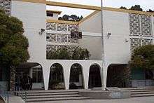 Terra Nova High School | ||
Public libraries
San Mateo County Library, a member of the Peninsula Library System, operates the Pacifica-Sanchez Library and the Pacifica-Sharp Park Library.[25]
Notable residents
- Rob Schneider grew up in Pacifica. In 1997 he formed the Rob Schneider Music Foundation to support its school music program, and has since donated approximately $2 million.
- In 1971, Pacifica gained worldwide attention as the popular St. Peter's Catholic priest, Father Bob Duryea, was excommunicated, after a defiant confrontation with the church, for being married.[26]
See also
- Category:People from Pacifica, California
Notes
- ↑ "California Cities by Incorporation Date" (Word). California Association of Local Agency Formation Commissions. Retrieved August 25, 2014.
- ↑ "2010 Census U.S. Gazetteer Files – Places – California". United States Census Bureau.
- ↑ "Pacifica". Geographic Names Information System. United States Geological Survey. Retrieved January 9, 2015.
- ↑ Archived April 27, 2009, at the Wayback Machine.
- ↑ Sharp Park
- ↑ "Annual Estimates of the Resident Population for Incorporated Places: April 1, 2010 to July 1, 2015". Retrieved July 2, 2016.
- ↑ "Census of Population and Housing". Census.gov. Retrieved June 4, 2015.
- ↑ "2010 Census Interactive Population Search: CA - Pacifica city". U.S. Census Bureau. Retrieved July 12, 2014.
- ↑ http://www.bayareacensus.ca.gov "Demographic Profile Bay Area Census" Check
|url=value (help). - ↑ "American FactFinder". United States Census Bureau. Retrieved 2008-01-31.
- ↑ American FactFinder. Factfinder.census.gov. Retrieved on 2013-07-21.
- ↑ City of Pacifica CAFR
- ↑ Pacifica Historic Weather Averages in California (94044). Intellicast. Retrieved on 2013-07-21.
- ↑ Archived July 13, 2015, at the Wayback Machine.
- ↑ Neighborhoods. City of Pacifica. Retrieved on 2013-07-21.
- ↑ City Of Pacifica website
- ↑ City of Pacifica website
- ↑ Pacifica City Council Approves Outsourcing Police CommunicationS to South San Francisco | Public Safety Communications. Psc.apcointl.org (2011-06-29). Retrieved on 2013-07-21.
- ↑ "Statewide Database". UC Regents. Retrieved December 3, 2014.
- ↑ "California's 14th Congressional District - Representatives & District Map". Civic Impulse, LLC. Retrieved March 12, 2013.
- ↑
- ↑ http://www.hallman.org/pacifica/portola.html
- ↑ "The San Francisco Call, 1908.". Retrieved 2009-09-05.
- ↑ Hunter, Chris; Drake, Bill; Pacifica Historical Society (2002). Pacifica. Images of America. Arcadia Publishing. pp. 65–66. ISBN 0738520683.
- ↑ "San Mateo County Library Locations." San Mateo County Library. Retrieved on October 6, 2009.
- ↑ Religion: Just Plain Bob. TIME (1971-04-26). Retrieved on 2013-07-21.
External links
| Wikimedia Commons has media related to Pacifica, California. |
- Official website
- Pacifica Historical Society
- City of Pacifica Commissions, Committees, and City Council meeting agendas
- Pacifica Public Libraries (Sharp Park and Sanchez) - branches of the San Mateo County Library
- Open Directory Project, Pacifica links
 |
Daly City | | ||
| Pacific Ocean | |
South San Francisco San Bruno | ||
| ||||
| | ||||
| Montara | Montara Mountain |
Municipalities and communities of San Mateo County, California, United States | ||
|---|---|---|
| Cities and towns | 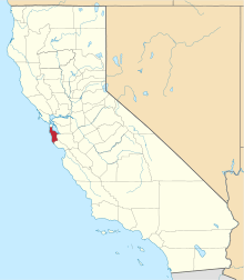 | |
| CDPs | ||
| Unincorporated communities | ||
| Ghost towns | ||
| Bodies of water |
|  |
|---|---|---|
| Counties | ||
| Major cities | ||
| Cities and towns 100k–250k | ||
| Cities and towns 50k–99k | ||
| Cities and towns 25k-50k | ||
| Cities and towns 10k–25k |
| |
| Sub-regions | ||