Japan National Route 2
| |
|---|---|
| 国道2号 (Kokudō Ni-gō) | |
 | |
 | |
| Route information | |
| Length: | 533.2 km (331.3 mi) |
| Major junctions | |
| East end: |
|
|
| |
| West end: |
|
| Highway system | |
|
National highways of Japan Expressways of Japan | |

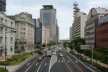
Route 2 passing through Kobe
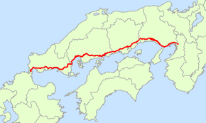
National Route 2 is a major highway on the islands of Honshū and Kyūshū in Japan. It follows the old Sanyōdo westward from the city of Osaka, Osaka Prefecture in the Kansai region to the city of Kitakyūshū in Fukuoka Prefecture, passing through the San'yō region en route. Between Hyōgo Prefecture and Yamaguchi Prefecture it parallels the Sanyō Expressway; it crosses the Kanmon Straits through the Kanmon Roadway Tunnel. Its total length is 533.2 km. At its Osaka terminus, it meets Route 1; at its western terminus, it links with Routes 3 and 10.[1][2]
Route Data
- Length: 533.2 km (331.4 mi)
- Origin: Umeda, Kita-ku, Osaka (originates at the terminus of Routes 1, 25 and 176 and the origins of Routes 26, 163 and 165)
- Terminus: Moji-ku, Kitakyushu (ends at the origins of Routes 3 and 10)
- Major cities: Kobe, Himeji, Himeji, Okayama, Kurashiki, Fukuyama, Hiroshima, Iwakuni, Shimonoseki
History
- 1952-12-04 - First Class National Highway 2 (from Osaka to Kitakyushu)
- 1965-04-01 - General National Highway 2 (from Osaka to Kitakyushu)
Overlapping sections
- From Nishinomiya (Fudabasuji intersection) to Kobe (San'nomiya-East intersection): Route 171
- From Kobe (Higashi-Shiriike intersection) to Akashi (Kariguchi intersection): Route 28
- From Kobe (Higashi-Shiriike intersection) to Akashi (Kokubo intersection): Route 250
- From Himeji to Taishi Town (Taishi-Kamiota IC): Route 29
References
| Wikimedia Commons has media related to Route 2 (Japan). |
This article is issued from Wikipedia - version of the 11/5/2016. The text is available under the Creative Commons Attribution/Share Alike but additional terms may apply for the media files.