Hida, Gifu
| Hida 飛騨市 | ||
|---|---|---|
| City | ||
|
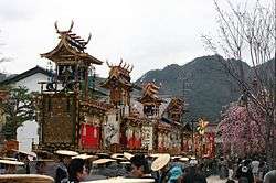
Furukawa Festival, held annually in April | ||
| ||
 Location of Hida in Gifu Prefecture | ||
 Hida Location in Japan | ||
| Coordinates: 36°14′N 137°11′E / 36.233°N 137.183°ECoordinates: 36°14′N 137°11′E / 36.233°N 137.183°E | ||
| Country | Japan | |
| Region | Chūbu | |
| Prefecture | Gifu Prefecture | |
| Government | ||
| • Mayor | Hisanori Inoue | |
| Area | ||
| • Total | 792.31 km2 (305.91 sq mi) | |
| Population (July 2011[1]) | ||
| • Total | 26,403 | |
| • Density | 33/km2 (86/sq mi) | |
| Symbols | ||
| • Tree | Beech | |
| • Flower | Lysichiton camtschatcense | |
| Time zone | Japan Standard Time (UTC+9) | |
| City hall address |
2-22 Hon-machi, Furukawa-chō, Hida-shi, Gifu-ken 509-4292 | |
| Website |
www | |

Hida (飛騨市 Hida-shi) is the northernmost city in Gifu Prefecture, Japan. It received its name from the historical province of Hida Province, which was centered on the same area.
The official kanji for the city is actually 飛驒, which uses the old rendering of the 騨 character. However, the 驒 characters is not included on the official list of usable characters (as decided by the Ministry of Internal Affairs and Communications), so the 騨 character is often used outside of the city.
As of July 2011, the city has an estimated population of 26,403 and a population density of 33 persons per km². The total area is 792.31 km².

History
The modern city of Hida was established on February 1, 2004, from the merger of the towns of Furukawa and Kamioka, and the villages of Kawai and Miyagawa (all from Yoshiki District).
Geography
The city is located on the northern part of the Hida Plateau. The city is geographically divided into two areas, the eastern and western half. The Takahara River flows through the eastern half the city and the Miya River flows through the western half (both rivers are part of the Jinzū River river system). A mountainous region separates the two sides and the population generally clusters around the two river valleys.
Much of the area within the city's borders is covered in forests. There are many mountains that reach higher than 1,000 feet (305 m), though some peaks in the Hida Mountains reach even higher, going beyond 2,000 feet (610 m).
Economy
The main two traditional economies in the city are the production of sake and Japanese candles. The Furukawa area of the city is known for both of these crafts, though the Kamioka section is also known for its sake production.
Festival in Hida
Furukawa Festival, a famous for festival in Gifu Prefecture, with this event held on every April.
Neutrino observatory
Super-Kamiokande neutrino observatory together with the data processing centre (Kamioka Observatory) is located in Kamioka since 2002.[2]
Transportation
Railroad
JR Central operates seven stations within Hida along the Takayama Main Line. The main station for the city is Hida-Furukawa Station. The other six stations are north of Hida-Furukawa and are, in order: Sugisaki, Hida-Hosoe, Tsunogawa, Sakakami, Utsubo and Sugihara stations.
Highway
The major expressway through the city is the Tōkai-Hokuriku Expressway, which connects the cities of Nagoya and Gifu with Toyama. Four national highways run through the city as well: National Routes 41, 360, 471 and 472.
Neighboring municipalities
- Gifu Prefecture
- Toyama Prefecture
References
- ↑ 岐阜県の人口・世帯数人口動態統計調査結果. Gifu prefectural website (in Japanese). Gifu Prefecture. Retrieved September 11, 2011.
- ↑ http://www.mindat.org/loc-2199.html
External links
| Wikivoyage has a travel guide for Hida. |
 Media related to Hida, Gifu at Wikimedia Commons
- Hida City official website (Japanese, English, Korean and Chinese)
| Core city | ||
|---|---|---|
| Cities | ||
| Anpachi District | ||
| Fuwa District | ||
| Hashima District | ||
| Ibi District | ||
| Kamo District | ||
| Kani District | ||
| Motosu District | ||
| Ōno District | ||
| Yōrō District | ||