Toyama, Toyama
| Toyama 富山市 | ||
|---|---|---|
| Core city | ||
| Toyama City | ||
 | ||
| ||
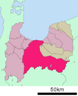 Location of Toyama in Toyama Prefecture | ||
 Toyama Location in Japan | ||
| Coordinates: 36°42′N 137°13′E / 36.700°N 137.217°ECoordinates: 36°42′N 137°13′E / 36.700°N 137.217°E | ||
| Country | Japan | |
| Region | Chūbu (Hokuriku) | |
| Prefecture | Toyama Prefecture | |
| Government | ||
| • Mayor | Masashi Mori (since January 2002) | |
| Area | ||
| • Total | 1,241.85 km2 (479.48 sq mi) | |
| Population (May 31, 2011) | ||
| • Total | 417,324 | |
| • Density | 336.05/km2 (870.4/sq mi) | |
| Symbols | ||
| • Tree | Zelkova serrata | |
| • Flower | Thistle | |
| Time zone | Japan Standard Time (UTC+9) | |
| City hall address |
Higashi-shinmachi 7-38, Toyama City, Toyama Prefecture (富山県富山市東新町7番38号) 930-8510 | |
| Website |
www | |

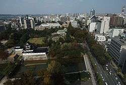
Toyama (富山市 Toyama-shi) is the capital city of Toyama Prefecture, Japan, located on the coast of the Sea of Japan in the Chūbu region on central Honshū, about 200 km (120 mi) north of the city of Nagoya and 300 km (190 mi) northwest of Tokyo.
Historically, Toyama was the capital of Etchu Province. The modern city was incorporated on April 1, 1889, withdrawing from Kaminiikawa District.
As of May 31, 2011, the city has an estimated population of 417,324, with 162,663 households and a population density of 336.05 persons per km². The total area is 1,241.85 km².
Toyama is served by Toyama Airport and Toyama Station of West Japan Railway Company, with Toyama Light Rail, Toyama Chiho Railway.
History
Early history
The Toyama Plain is good farmland and historically it was a point of strategic and traffic importance. During the Feudal Age, it was frequently turned into a battlefield. Toward the end of the period of confusion, Sassa Narimasa became the governor of Etchū Province (the ancient name for present Toyama), and he accomplished the feat of taming the rampaging rivers, bringing about an even more flourishing agricultural industry in Toyama. In the early Edo Period, a positive industrial promotion policy was implemented on the production of medicine and washi (Japanese paper). Also, thanks to the improvement of both land and sea transportation routes, these industries thrived and Toyama became known nationwide as the province of medicine.
Recent history
After the Meiji Restoration, heavy and chemical industries developed in Toyama, based on abundant electricity which was generated in some hydro power stations in the mountains near-by. During World War II, Allied POWs were sent to Toyama as forced labor.[1] Although the streets of Toyama were devastated by an air raid in August 1945, Toyama has become one of the most influential cities on the Japan Sea side with its good water supply, drainage system and thriving agricultural, forestry, fishery, commercial and manufacturing industries.
The city was completely destroyed on the night of August 1–2, 1945, possibly due to it being a major center for the Japanese military holding American prisoners of war. At the time of the bombing, the city was a center for aluminum, ball-bearing and special steel production.[2][3] The city during the time had a population of around 150,000 residents.
2005 mergers
On April 1, 2005, the towns of Ōsawano and Ōyama (both from Kaminiikawa District), the towns of Fuchū and Yatsuo, and the villages of Hosoiri and Yamada (all from Nei District) were merged into Toyama. Kaminiikawa District and Nei District were both dissolved as a result of this merger.
Geography
Location
Located in the middle of its prefecture, Toyama is a seaside city by the coast of the Sea of Japan and in front of Miura Peninsula. Its municipal territory borders with the Gifu Prefecture and with the municipalities of Imizu, Namerikawa, Tonami, Nanto, Hida and Takayama.[4]
Nearest towns are the ones of Imizu (west), and Namerikawa (east), both part of Toyama urban area and by the sea. Nearest city is Kanazawa, the capital of Ishikawa Prefecture, that is 65 km far.
Climate
Toyama has a humid subtropical climate (Köppen climate classification Cfa) with hot, humid summers and cool winters. Precipitation is abundant throughout the year, particularly in July, September and from November through January. Despite winter in Toyama being relatively mild, its position near the Sea of Japan places it within the heavy snow belt of Japan and on average 3.8 m (12 ft) of snow falls each season, almost all of it from December through March, as well as occasionally experiencing some tremendous amounts of snowfall.
| Climate data for Toyama, Toyama (1981–2010) | |||||||||||||
|---|---|---|---|---|---|---|---|---|---|---|---|---|---|
| Month | Jan | Feb | Mar | Apr | May | Jun | Jul | Aug | Sep | Oct | Nov | Dec | Year |
| Record high °C (°F) | 20.9 (69.6) |
22.5 (72.5) |
25.7 (78.3) |
32.4 (90.3) |
32.6 (90.7) |
36.4 (97.5) |
38.8 (101.8) |
39.5 (103.1) |
38.3 (100.9) |
33.3 (91.9) |
29.2 (84.6) |
21.6 (70.9) |
39.5 (103.1) |
| Average high °C (°F) | 6.0 (42.8) |
6.8 (44.2) |
10.9 (51.6) |
17.3 (63.1) |
21.9 (71.4) |
25.1 (77.2) |
29.0 (84.2) |
30.9 (87.6) |
26.5 (79.7) |
21.1 (70) |
15.3 (59.5) |
9.6 (49.3) |
18.4 (65.1) |
| Daily mean °C (°F) | 2.7 (36.9) |
3.0 (37.4) |
6.3 (43.3) |
12.1 (53.8) |
17.0 (62.6) |
20.9 (69.6) |
24.9 (76.8) |
26.6 (79.9) |
22.3 (72.1) |
16.4 (61.5) |
10.8 (51.4) |
5.7 (42.3) |
14.1 (57.4) |
| Average low °C (°F) | −0.1 (31.8) |
−0.3 (31.5) |
2.2 (36) |
7.2 (45) |
12.6 (54.7) |
17.4 (63.3) |
21.5 (70.7) |
22.9 (73.2) |
18.8 (65.8) |
12.4 (54.3) |
6.8 (44.2) |
2.4 (36.3) |
10.3 (50.5) |
| Record low °C (°F) | −11.9 (10.6) |
−11.1 (12) |
−7 (19) |
−2.2 (28) |
2.3 (36.1) |
7.7 (45.9) |
13.0 (55.4) |
14.1 (57.4) |
8.9 (48) |
1.9 (35.4) |
−2 (28) |
−8.5 (16.7) |
−11.9 (10.6) |
| Average precipitation mm (inches) | 259.5 (10.217) |
172.1 (6.776) |
158.5 (6.24) |
122.2 (4.811) |
134.2 (5.283) |
182.6 (7.189) |
240.4 (9.465) |
168.3 (6.626) |
220.2 (8.669) |
160.7 (6.327) |
234.4 (9.228) |
247.0 (9.724) |
2,300.1 (90.555) |
| Average snowfall cm (inches) | 159 (62.6) |
125 (49.2) |
36 (14.2) |
1 (0.4) |
0 (0) |
0 (0) |
0 (0) |
0 (0) |
0 (0) |
0 (0) |
2 (0.8) |
57 (22.4) |
380 (149.6) |
| Average precipitation days (≥ 0.5 mm) | 23.7 | 19.9 | 18.7 | 13.1 | 11.8 | 12.3 | 14.7 | 11.0 | 13.9 | 14.4 | 17.7 | 22.0 | 193.2 |
| Average snowy days | 19.1 | 16.1 | 9.1 | 0.8 | 0 | 0 | 0 | 0 | 0 | 0.6 | 1.0 | 9.7 | 56.4 |
| Average relative humidity (%) | 82 | 79 | 73 | 69 | 72 | 79 | 81 | 77 | 79 | 77 | 77 | 80 | 77.1 |
| Mean monthly sunshine hours | 68.1 | 86.3 | 131.3 | 174.9 | 191.1 | 150.2 | 147.1 | 201.3 | 133.1 | 142.7 | 102.8 | 75.8 | 1,604.7 |
| Source #1: Japan Meteorological Agency[5] | |||||||||||||
| Source #2: Japan Meteorological Agency (records)[6] | |||||||||||||
Economy
Hokuriku Electric Power Company (colloquially known as Hokuden), the regional power-supply monopoly, is based in Toyama.[7] Bearing parts and industrial robot company Nachi-Fujikoshi and software company INTEC are also headquartered in Toyama.[8][9]
Regional banks include Hokuriku Bank, First Bank of Toyama, and Toyama Bank.[10]
Points of interest
- Botanic Gardens of Toyama
- Toyama International Conference Center[11]
- Toyama Castle
- Museum of Modern Art of Toyama
- Toyama Athletic Recreation Park Stadium, home of Toyama's representative in the J. League, Kataller Toyama football club
- Toyama Glass Studio[12]
Festivals and events
- Toyama Chindon Contest (Toyama Band of musical sandwichmen contest) - proposed by the Toyama Chamber of Commerce in 1955 and is held annually in early April. This event has become a festival, and many bands of sandwichmen (men wearing sandwich boards for advertisements) participate, attracting many tourists every year. But in 2011, the event was cancelled in the wake of the 2011 Tohoku earthquake and tsunami.
- Kaze No Bon - held annually on September 1 to 3, in the Yatsuo region.[13]
Educational institutions
- Toyama College
- Toyama National College of Technology
- Toyama Prefectural University
- Toyama University of International Studies
- University of Toyama
Transport
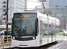
Toyama is served by a tram network divided into the Toyama City Tram Line and the Toyama Light Rail Toyamakō Line. Toyama railway station, operated by JR West, Toyama Chihō Railway and Ainokaze Toyama Railway, is connected to both tramway lines and is also served by Shinkansen.
Toyama Airport (IATA: TOY, ICAO: RJNT), located some km south of the city, is an international airport with some flights to China, Taiwan and South Korea.
Sister cities
 Durham, North Carolina, United States
 Mogi das Cruzes, São Paulo State, Brazil
 Qinhuangdao, Hebei, China
 Wellington, New South Wales, Australia
References
- ↑ Pennington, Matthew (25 April 2015). "'The truth needs to be told' about Japan's war history, some vets say". Stars and Stripes. United States. Associated Press. Retrieved 25 April 2015.
- ↑ Info on att.net
- ↑ Info on echigonagaoka.com
- ↑ 4807827 Toyama on OpenStreetMap
- ↑ "平年値(年・月ごとの値)". Japan Meteorological Agency. Retrieved 2011-11-18.
- ↑ "観測史上1~10位の値(年間を通じての値)". Japan Meteorological Agency. Retrieved 2011-11-18.
- ↑ "Annual Report 2013." Hokuriku Electric Power Company. Retrieved on August 28, 2014.
- ↑ "Corporate Info." Nachi-Fujikoshi. Retrieved on August 27, 2014.
- ↑ "About INTEC." INTEC. Retrieved on August 27, 2014.
- ↑ "Corporate Data." Hokuhoku Financial Group. Retrieved on August 28, 2014.
- ↑ Toyama International Conference Center
- ↑ Toyama Glass Studio
- ↑ Visit Toyama. (2008). Visit Toyama. Retrieved Jan. 6, 2013, from prefectural web site, English version.
External links
| Wikimedia Commons has media related to Toyama, Toyama. |
| Wikivoyage has a travel guide for Toyama. |
- Toyama City official website (Japanese)
- Toyama City official website (English)
- Toyama City's Website for foreign people Visit Toyama
- Toyama Castle