Kankali Tila
| Part of a series on |
| Jainism |
|---|
 |
|
Jain prayers |
|
Ethics |
|
Major figures |
|
Major sects |
|
Festivals |
|
Pilgrimages |
|
|
Kankali Tila (also Kankali mound or Jaini mound) is a mound located at Mathura in the Indian state of Uttar Pradesh. The name of the mound is derived from a modern temple of Hindu goddess Kankali. The famous Jain stupa was excavated here in 1890-91 by Alois Anton Führer (Dr. Führer).[1]
The mound almost rectangular in shape is 500 feet long by 350 feet broad.[1] Kankali Tila brought forth many treasures of Jain art. The archaeological findings testifies the existence of two Jain temples and stupas. Numerous Jain sculptures, Ayagapattas (tablet of homage),[2] pillars, crossbeams and lintels were found during archaeological excavations. Some of the sculptures are provided with inscriptions that report on the contemporary society and organization of the Jain community. Most sculptures could be dated from the 2nd century BC to the 12th century CE. These sculptures are now housed in a museum at Lucknow.
Excavation
.jpg)
Alexander Cunningham worked at the western end in March and November 1871. The objects found by Mr. Cunningham were all Jain, with the exception of one ten-armed Brahmanical figure. Mr. Growse operated on the northern portion in 1875. In Volume XVII of the "Reports" (page 111), Mr. Cunningham noted that in the season of 1881-82 he dug up many Jain figures, including one inscribed with the name of Vardhamana, the last of the 24 Jain Tirthankara.[3] Dr. Burgess and Dr. Fuhrer extended the excavations to the eastern end at different times from 1887 to 1896. Mr. Harding, a predecessor of Mr. Growse as Magistrate of Mathura, also made some excavations. The excavations at Kankali Tila acted as a testimony to the claims made by Jains regarding the great antiquity of their religion.[4]
Gallery
 Quadruple Jain Image, excavated from Kankali Tila, c. 1st century CE
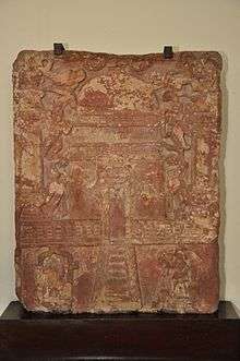
 Jain Tablet Homage Set-up by Vasu the daughter of Courtesan Lavana Sobhika - Circa 1st Century CE - Kankali Mound (ACCN 00-Q-7 - Government Museum, Mathura)
 Description of the tablet
 Broken idol of Rishabhanatha, first Jain Tirthankara, excavated from Kankali Mound (Government Museum - Mathura)
 Three Quadruple images of Tirthankar excavated from Kankali Tila (Samvat 15)
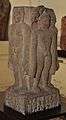
.jpg) Images of Tirthankar Mahavira excavated from Kankali Tila
Images of Tirthankar Mahavira excavated from Kankali Tila
See also
| Wikimedia Commons has media related to Kankali Tila. |
References
- 1 2 Smith 1901, p. Introduction.
- ↑ Das 1980, p. 171.
- ↑ Smith 1901, p. 2.
- ↑ Thomas 1877, p. 80.
Sources
- Smith, Vincent Arthur (1901), The Jain stupa and other antiquities of Mathura
- Das, Kalyani (1980), Early Inscriptions of Mathurā
- Thomas, Edward (1877), "Jainism or The early faith of Asoka", Nature, London: London, Trübner & co., 16 (407): 329, Bibcode:1877Natur..16..329., doi:10.1038/016329a0
| Gods | |||||||
|---|---|---|---|---|---|---|---|
| Philosophy | |||||||
| Branches |
| ||||||
| Practices | |||||||
| Literature | |||||||
| Symbols |
| ||||||
| Ascetics | |||||||
| Scholars | |||||||
| Community | |||||||
| Jainism in |
| ||||||
| Jainism and | |||||||
| Dynasties and empires | |||||||
| Related | |||||||
| Lists | |||||||
| Navboxes |
| ||||||
| |||||||
Coordinates: 27°29′51″N 77°40′20″E / 27.4976°N 77.6721°E