Kyustendil
| Kyustendil Кюстендил | ||
|---|---|---|
| town | ||
 | ||
| ||
 Kyustendil Location of Kyustendil | ||
| Coordinates: 42°17′N 22°41′E / 42.283°N 22.683°ECoordinates: 42°17′N 22°41′E / 42.283°N 22.683°E | ||
| Country | Bulgaria | |
| Province (Oblast) | Kyustendil | |
| Government | ||
| • Mayor | Petar Paunov | |
| Area | ||
| • town | 28.72 km2 (11.09 sq mi) | |
| • Urban | 979.91 km2 (378.35 sq mi) | |
| Elevation | 560 m (1,840 ft) | |
| Population (Census February 2011) | ||
| • town | 44,532 | |
| • Density | 1,600/km2 (4,000/sq mi) | |
| • Urban | 60,681 | |
| Time zone | EET (UTC+2) | |
| • Summer (DST) | EEST (UTC+3) | |
| Postal Code | 2500 | |
| Area code(s) | 078 | |
| Vehicle registration | KH | |
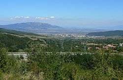
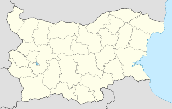
Kyustendil (Bulgarian: Кюстендил) is a town in the far west of Bulgaria, and the capital of the Kyustendil Province. The town is situated in the southern part of the Kyustendil Valley, near the borders of Serbia and the Republic of Macedonia; 90 km southwest of Sofia, 130 km northeast of Skopje and 243 km north of Thessaloniki. The total population counts 44,532 people, with a Bulgarian majority and Roma minority. During the Iron Age, a Thracian settlement was located within the town, later known as Roman in the 1st century AD. In the Middle Ages, the town switched hands between the Byzantine Empire, Bulgaria and Serbia, prior to Ottoman annexation in 1395. After centuries of Ottoman rule, the town became part of an independent Bulgarian state in 1878.
Name
The modern name is derived from Kösten, the Turkified name of the 14th-century local feudal Constantine Dragaš, from Latin constans, "steadfast" + the Turkish il "shire, county" or "bath/spa".[1][2] The town was known in Antiquity as Pautalia.
Geography
Kyustendil is a national balneological resort at an altitude of 600 metres. There are more than 40 mineral springs in the town. The waters have a high content of sulfite compounds. These are used for the treatment of the locomotory system, gynecological and other kinds of diseases. The resort region includes several baths, balneological complexes and others.
Kyustendil is located at the foot of the Osogovo mountain, on both banks of the Banshtica River and is a well-known centre of balneology and fruit growing. The town is 90 kilometres southwest of Sofia, 69 km northwest of Blagoevgrad and 22 km from the border with the Republic of Macedonia and Serbia. The fortress was built by the Romans. Thermae, basilicas, floor mosaics have been uncovered.[3]
Climate
Kyustendil has a continental climate with Mediterranean influence (mostly along the Struma river). The average annual temperature is around 12 °C (54 °F). The highest average temperatures are in July and August at 22 to 23 °C (72–73 °F) and lowest in January at 0 to 1 °C (32–34 °F). The annual temperature range is 22 °C (40 °F). It is relatively large and is an indicator of the predominant continental nature of the climate. Summers are warm and long, winters are short and cool, spring comes early and stays steady after the first days of March and the autumn is long, warm and sunny while maintaining stable until the end of November. Rainfall is moderate – average 624 mm (24.6 in), and there is snow on average 20–25 days in winter, although it may vary significantly. Due to moderately severe cloudy and hazy low (average 22 days per year) duration of sunshine is significant – about 2,300 hours per year. The second half of the summer and early autumn in the town are the sunniest of the year, and the cloud cover is mostly in the winter months. Humidity is moderate. It varies between 65 and 70%, and is relatively low in the summer months (especially in August). Kyustendil valley is characterized by low windiness, spring being the most windy season and autumn the most quiet. The average annual wind speed is 1.4 m/s (4.6 ft/s). During the winter and spring months in the city appears warm and gusty wind "foehn", which causes sudden warming of time. The temperature regime is characterized by some special features. Winter temperature inversions occur, and in the summer as a result of overheating of the daily maximum air temperatures rise to 35 to 37 °C (95–99 °F). Summer nights are mild with temperatures in the range of 18 to 22 °C (64–72 °F), although temperatures tend to drop below 18 °C (64 °F) in the early mornings for about two hours. The lowest temperature in the city is measured on 20 January 1967 at −27.2 °C (−17.0 °F), and the highest 43 °C (109 °F) reached both in July and August, most recently on 24 July 2007.
| Climate data for Kyustendil, Bulgaria (2002–2014) | |||||||||||||
|---|---|---|---|---|---|---|---|---|---|---|---|---|---|
| Month | Jan | Feb | Mar | Apr | May | Jun | Jul | Aug | Sep | Oct | Nov | Dec | Year |
| Average high °C (°F) | 5.5 (41.9) |
8.2 (46.8) |
13.4 (56.1) |
19.2 (66.6) |
24.0 (75.2) |
27.8 (82) |
30.7 (87.3) |
31.2 (88.2) |
26.1 (79) |
19.5 (67.1) |
13.0 (55.4) |
6.8 (44.2) |
18.8 (65.8) |
| Daily mean °C (°F) | 0.5 (32.9) |
2.0 (35.6) |
7.4 (45.3) |
12.7 (54.9) |
17.4 (63.3) |
20.6 (69.1) |
23.0 (73.4) |
23.2 (73.8) |
19.0 (66.2) |
13.0 (55.4) |
7.8 (46) |
2.0 (35.6) |
12.5 (54.5) |
| Average low °C (°F) | −3.9 (25) |
−3.1 (26.4) |
1.5 (34.7) |
6.2 (43.2) |
10.2 (50.4) |
13.1 (55.6) |
14.6 (58.3) |
14.5 (58.1) |
11.3 (52.3) |
6.5 (43.7) |
2.5 (36.5) |
−1.9 (28.6) |
6.1 (43) |
| Average precipitation mm (inches) | 48 (1.89) |
45 (1.77) |
42 (1.65) |
52 (2.05) |
68 (2.68) |
65 (2.56) |
54 (2.13) |
36 (1.42) |
38 (1.5) |
59 (2.32) |
62 (2.44) |
55 (2.17) |
624 (24.57) |
| Average precipitation days (≥ 0.1 mm) | 10 | 9 | 8 | 8 | 9 | 8 | 4 | 4 | 6 | 7 | 8 | 11 | 92 |
| Average snowy days (≥ 0.1 cm) | 9 | 6 | 3 | 0 | 0 | 0 | 0 | 0 | 0 | 0 | 1 | 4 | 23 |
| Mean monthly sunshine hours | 85 | 117 | 168 | 214 | 261 | 314 | 323 | 312 | 223 | 151 | 106 | 75 | 2,349 |
| Source: Stringmeteo.com[4] | |||||||||||||
| Kyustendil | ||||||||||||||||||||||||||||||||||||||||||||||||||||||||||||
|---|---|---|---|---|---|---|---|---|---|---|---|---|---|---|---|---|---|---|---|---|---|---|---|---|---|---|---|---|---|---|---|---|---|---|---|---|---|---|---|---|---|---|---|---|---|---|---|---|---|---|---|---|---|---|---|---|---|---|---|---|
| Climate chart (explanation) | ||||||||||||||||||||||||||||||||||||||||||||||||||||||||||||
| ||||||||||||||||||||||||||||||||||||||||||||||||||||||||||||
| ||||||||||||||||||||||||||||||||||||||||||||||||||||||||||||
History
Prehistory and Roman era
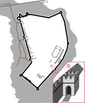
A Thracian settlement was founded at the place of the modern town in the 5th-4th centuries BC and the Romans developed it into an important stronghold, balneological resort and trade junction called Pautalia (Thracian for "town of springs") in the 1st century AD, when it was administratively part of Macedonia. Many Thracian and Roman objects are exhibited in the town's Regional History Museum, most notably an impressive numismatic collection. A fortress was built in the town in the 4th century (known by its later Ottoman name Hisarlaka).
Middle Ages
The town was mentioned under the Slavic name of Velbazhd (Велбъжд, meaning "camel")[3] in a 1019 charter by the Byzantine Emperor Basil II. It became a major religious and administrative centre of the Byzantine Empire, and subsequently the Second Bulgarian Empire after Kaloyan conquered the area between 1201 and 1203.
In 1282, Serbian king Stefan Milutin defeats the Byzantine Empire and conquered Velbazhd.
In 1330, the Serbs defeated the Bulgarians in the vicinity, effectively keeping the region to the Serbian Kingdom. Serbian magnate Dejan, one of the prominent figures of the Serbian Empire and its subsequent fall, had initially held a large province in the Kumanovo region under Dušan, and was later as despot under Uroš V assigned the Upper Struma river with Velbuzhd.[6][7] Upon Dejan's death, his possessions in Žegligovo and Upper Struma were given to his two sons, Jovan Dragaš (d. 1378) and Konstantin (d. 1395). The Dejanović brothers ruled a spacious province in eastern Macedonia,[8] in the southern lands of the Empire, and remained loyal to Uroš V,[9] until 1373, when the Ottoman army compelled Jovan to recognize Ottoman vassalage.[10]
Ottoman era
The city was a sanjak centre initially in Rumelia province, after that in the Bitola and Niš vilayets. It was a kaza centre in the Sofia sanjak of Danube Province until the creation of the Principality of Bulgaria in 1878.
Modern
The residents of Kyustendil took an active part in the Bulgarian National Revival and crafts and trade flourished. The town was liberated from Ottoman rule on 29 January 1878.
Demographics
According to the latest 2011 census data, people who chose to declare their ethnic identity were distributed as follows:[11][12]
- Bulgarians: 36,732 (82.5%)
- Roma: 5,179 (11.6%)
- Turks: 2 (0.0%)
- Others: 143 (0.3%)
- Indefinable: 296 (0.7%)
- Undeclared: 2,161 (4.9%)
Total: 44,513
Roma people are mainly concentrated within the town limits. In the mean time, about a fourth of Bulgarians live in the surrounding villages, also part of the Municipality of Kyustendil.
Religion
Kyustendil today belongs to the Sofia diocese in regards of church-administrative structure. The city is the center of the vicarage and the Kyustendil Eparchy. In the past, Kyustendil was the seat of the diocese, that latter was closed in 1884. The majority of the urban population profess the Orthodox faith today, there are several Christian denominations associated with Protestantism and a small Jewish community. During Ottoman rule Kyustendil had mostly Turkish population profess Islam but of the many mosques of the time, are now saved only two. Today the city has only Christian churches operating.
Honours
Kyustendil Ridge in Graham Land, Antarctica is named after the city,[13] and Pautalia Glacier on Livingston Island in the South Shetland Islands, Antarctica is named after Pautalia (its Thracian ancestor settlement).[14]
Notable people
- Constantine Dragaš, 14th-century local Serbian ruler
- Ilyo Voyvoda (1805–1898), hajduk, revolutionary and Bulgarian liberation fighter (died in Kyustendil)
- Dimitar Peshev (1894–1973), World War II Minister of Justice and Deputy speaker of the Parliament who prevented the deportation of the Bulgarian Jews to Nazi death camps
- Todor Angelov (1900–1943), communist revolutionary and Belgian resistance fighter
- Nikolay Diulgheroff (1901–1982), futurist artist
- Marin Goleminov (1908–2000), composer
Gallery
 The municipality hall (architect Friedrich Grünanger)
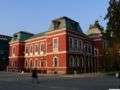 The municipality hall
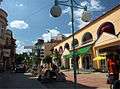
 10th-11th-century Church of St George in the Kolusha neighbourhood
 Timber-framed tower
 Fatih Mehmet Mosque (15th century)
 Cifte Spa Bath
 The 15th-16th-century Pirgova Tower
.jpg) The Hisarlaka medieval fortress lying atop a hill overlooking the town
The Hisarlaka medieval fortress lying atop a hill overlooking the town The Church of Saint Menas, built in 1859, situated in the west part of Kystendil.
.JPG) Building in Kyustendil
Building in Kyustendil
References
- ↑ Ćorović 2001, ch. 3, XIII. Boj na Kosovu
- ↑ Матанов, Христо (1986). "Феодални княжества и владетели през последните десетилетия на XIV век". Югозападните български земи през XIV век (in Bulgarian). София: Наука и изкуство. p. 126.
- 1 2 Adrian Room, "Placenames of the World" ISBN 0-7864-2248-3 McFarland & Company (2005)
- ↑ , Stringmeteo.com Retrieved May 4, 2013.
- ↑ http://www.stringmeteo.com/synop/index.php
- ↑ Mihaljčić 1989, pp. 79-81
- ↑ Fajfric, 42
- ↑ Samardzic 1892 p. 22:
Синови деспота Дејана заједнички су управљали пространом облашћу у источној Македонији, мада је исправе чешће потписивао старији, Јован Драгаш. Као и његов отац, Јован Драгаш је носио знаке деспотског достојанства. Иако се као деспот помиње први пут 1373, сасвим је извесно да је Јован Драгаш ову титулу добио од цара Уроша. Високо достојанство убрајало се, како је …
- ↑ Fine 1994, p. 358
- ↑ Edition de lA̕cadémie bulgare des sciences, 1986, "Balkan studies, Vol. 22", p. 38
- ↑ (Bulgarian) Population on 1 February 2011 by provinces, municipalities, settlements and age; National Statistical Institute
- ↑ Population by province, municipality, settlement and ethnic identification, by 1 February 2011; Bulgarian National Statistical Institute (Bulgarian)
- ↑ Kyustendil Ridge. SCAR Composite Antarctic Gazetteer.
- ↑ Pautalia Glacier. SCAR Composite Antarctic Gazetteer.
External links
| Wikimedia Commons has media related to Kyustendil. |
- http://kn.government.bg/index.php?lang=en/Provides information about the region, photos, historical review, and development projects
- Kyustendil tourist destination – tourism opportunities in the Kyustendil region
- Kustendil Info, Information web Portal of Kyustendil
- KnCity.info, a website about Kyustendil
- Kyustendil at Journey.bg
- Kyustendil at BGGlobe
- Regional History Museum
 |
Serbia | Bosilegrad | Pernik | |
| Kriva Palanka | |
Bobov Dol | ||
| ||||
| | ||||
| Macedonia | Blagoevgrad | Dupnica |
Capital: Kyustendil | ||
| Villages |
| |
| Landmarks |
| |
| Culture | ||
| Notable people |
| |