Lafourche Parish, Louisiana
| Lafourche Parish, Louisiana | |
|---|---|
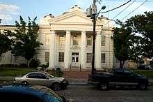 Lafourche Parish Courthouse | |
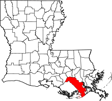 Location in the U.S. state of Louisiana | |
 Louisiana's location in the U.S. | |
| Founded | 1807 |
| Named for | la fourche, French for the fork |
| Seat | Thibodaux |
| Largest city | Thibodaux |
| Area | |
| • Total | 1,474 sq mi (3,818 km2) |
| • Land | 1,068 sq mi (2,766 km2) |
| • Water | 406 sq mi (1,052 km2), 28% |
| Population (est.) | |
| • (2013) | 97,141 |
| • Density | 90/sq mi (35/km²) |
| Congressional districts | 1st, 6th |
| Time zone | Central: UTC-6/-5 |
| Website |
www |
Lafourche Parish (French: Paroisse de la Fourche) is a parish located in the south of the U.S. state of Louisiana. As of the 2010 census, the population was 96,318.[1] The parish seat is Thibodaux.[2] The parish was formed in 1807.[3] It was originally the northern part of Lafourche Interior Parish, which consisted of the present parishes of Lafourche and Terrebonne. Lafourche Parish was named after the Bayou Lafourche.[4]
Lafourche Parish is part of the Houma-Thibodaux, LA Metropolitan Statistical Area. The state-recognized Native American Houma Tribe lives in both Lafourche and Terrebonne parishes.
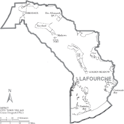
Geography
According to the U.S. Census Bureau, the parish has a total area of 1,474 square miles (3,820 km2), of which 1,068 square miles (2,770 km2) is land and 406 square miles (1,050 km2) (28%) is water.[5] To the south of the parish is the Gulf of Mexico.
Major highways
Adjacent parishes
- St. James Parish (north)
- St. John the Baptist Parish (north)
- St. Charles Parish (northeast)
- Jefferson Parish (east)
- Terrebonne Parish (west)
- Assumption Parish (northwest)
National protected area
Demographics
| Historical population | |||
|---|---|---|---|
| Census | Pop. | %± | |
| 1810 | 1,995 | — | |
| 1820 | 3,755 | 88.2% | |
| 1830 | 5,503 | 46.6% | |
| 1840 | 7,303 | 32.7% | |
| 1850 | 9,532 | 30.5% | |
| 1860 | 14,044 | 47.3% | |
| 1870 | 14,719 | 4.8% | |
| 1880 | 19,113 | 29.9% | |
| 1890 | 22,095 | 15.6% | |
| 1900 | 28,882 | 30.7% | |
| 1910 | 33,111 | 14.6% | |
| 1920 | 30,344 | −8.4% | |
| 1930 | 32,419 | 6.8% | |
| 1940 | 38,615 | 19.1% | |
| 1950 | 42,209 | 9.3% | |
| 1960 | 55,381 | 31.2% | |
| 1970 | 68,941 | 24.5% | |
| 1980 | 82,483 | 19.6% | |
| 1990 | 85,860 | 4.1% | |
| 2000 | 89,974 | 4.8% | |
| 2010 | 96,318 | 7.1% | |
| Est. 2015 | 98,325 | [6] | 2.1% |
| U.S. Decennial Census[7] 1790-1960[8] 1900-1990[9] 1990-2000[10] 2010-2013[1] | |||
As of the census of 2000, there were 89,974 people, 32,057 households, and 24,299 families residing in the parish. The latest estimates are at 90,255. The population density was 83 people per square mile (32/km²). There were 35,045 housing units at an average density of 32 per square mile (12/km²). The racial makeup of the parish was 82.85% White, 12.61% Black or African American, 2.30% Native American, 0.67% Asian, 0.02% Pacific Islander, 0.58% from other races, and 0.97% from two or more races. 1.43% of the population were Hispanic or Latino of any race. 19.12% reported speaking French or Cajun French at home, while 1.51% speak Spanish.[11]
There were 32,057 households out of which 37.80% had children under the age of 18 living with them, 59.10% were married couples living together, 12.40% had a female householder with no husband present, and 24.20% were non-families. 19.60% of all households were made up of individuals and 7.80% had someone living alone who was 65 years of age or older. The average household size was 2.75 and the average family size was 3.17.
In the parish the population was spread out with 27.30% under the age of 18, 10.50% from 18 to 24, 29.70% from 25 to 44, 21.30% from 45 to 64, and 11.30% who were 65 years of age or older. The median age was 34 years. For every 100 females there were 95.20 males. For every 100 females age 18 and over, there were 91.30 males.
The median income for a household in the parish was $34,910, and the median income for a family was $40,504. Males had a median income of $34,600 versus $19,484 for females. The per capita income for the parish was $15,809. About 13.20% of families and 16.50% of the population were below the poverty line, including 21.90% of those under age 18 and 18.30% of those age 65 or over.
Education
The parish is zoned to Lafourche Parish Public Schools.[12]
Residents of select portions of Lafourche Parish (particularly in parts of Grand Bois and Bourg) may attend schools in the Terrebonne Parish School District.[13]
High schools
- Central Lafourche in Mathews.
- South Lafourche in Galliano.
- Thibodaux High in Thibodaux.
Universities
- Nicholls State University in Thibodaux.
National Guard
D Company 2-156 Infantry Battalion of the 256TH Infantry Brigade Combat Team resides in Thibodaux, Louisiana
Communities
City
- Thibodaux (parish seat)
Towns
Census-designated places
Other areas
Notable people
- Donald G. Bollinger
- Thomas G. Clausen
- Francis Dugas
- Dick Guidry
- Harvey Peltier, Jr.
- Harvey Peltier, Sr.
- Glen Pitre
- Loulan Pitre, Jr.
See also
References
- 1 2 "State & County QuickFacts". United States Census Bureau. Retrieved August 10, 2013.
- ↑ "Find a County". National Association of Counties. Retrieved 2011-06-07.
- ↑ "Lafourche Parish". Center for Cultural and Eco-Tourism. Retrieved September 6, 2014.
- ↑ Gannett, Henry (1905). The Origin of Certain Place Names in the United States. Government Printing Office. p. 179.
- ↑ "2010 Census Gazetteer Files". United States Census Bureau. August 22, 2012. Retrieved September 1, 2014.
- ↑ "County Totals Dataset: Population, Population Change and Estimated Components of Population Change: April 1, 2010 to July 1, 2015". Retrieved July 2, 2016.
- ↑ "U.S. Decennial Census". United States Census Bureau. Retrieved September 1, 2014.
- ↑ "Historical Census Browser". University of Virginia Library. Retrieved September 1, 2014.
- ↑ "Population of Counties by Decennial Census: 1900 to 1990". United States Census Bureau. Retrieved September 1, 2014.
- ↑ "Census 2000 PHC-T-4. Ranking Tables for Counties: 1990 and 2000" (PDF). United States Census Bureau. Retrieved September 1, 2014.
- ↑ Language Map Data Center
- ↑
- ↑ "SCHOOL ATTENDANCE BOUNDARIES." Lafourche Parish Public Schools. Retrieved on December 2, 2016.
External links
- Lafourche Parish
- Lafourche Parish Public Library
- VisitLafourche.com - Tourist commission site
- DigInLafourche.com - Events and Attractions
 |
Assumption Parish | St. James Parish and St. John the Baptist Parish | St. Charles Parish | |
| Terrebonne Parish | |
Jefferson Parish | ||
| ||||
| | ||||
| Gulf of Mexico |
Municipalities and communities of Lafourche Parish, Louisiana, United States | ||
|---|---|---|
| City | | |
| Towns | ||
| CDPs | ||
| Other Unincorporated communities |
| |
| Footnotes | ‡This populated place also has portions in an adjacent parish or parishes | |
Coordinates: 29°29′N 90°24′W / 29.49°N 90.40°W