Lemon Township, Butler County, Ohio
| Lemon Township, Butler County, Ohio | |
|---|---|
| Township | |
|
Countryside in Lemon Township | |
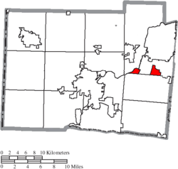 Location of Lemon Township in Butler County | |
| Coordinates: 39°27′17″N 84°23′34″W / 39.45472°N 84.39278°WCoordinates: 39°27′17″N 84°23′34″W / 39.45472°N 84.39278°W | |
| Country | United States |
| State | Ohio |
| County | Butler |
| Area | |
| • Total | 15.3 sq mi (39.7 km2) |
| • Land | 15.0 sq mi (38.8 km2) |
| • Water | 0.4 sq mi (1.0 km2) |
| Elevation[1] | 650 ft (198 m) |
| Population (2010) | |
| • Total | 13,875 |
| • Density | 927/sq mi (358.0/km2) |
| Time zone | Eastern (EST) (UTC-5) |
| • Summer (DST) | EDT (UTC-4) |
| FIPS code | 39-42672[2] |
| GNIS feature ID | 1085811[1] |

Lemon Township is one of thirteen townships in Butler County, Ohio, United States. Located in the northeastern part of the county, it includes most of the city of Monroe. It had a population of 13,875 at the 2010 census.[3] It is the only Lemon Township statewide.[4]
History
The township as originally created was approximately 36 square miles (93 km2) and included all of the Butler County portions of what is Middletown and most of the Butler County part of Monroe, the remainder being in Liberty Township. The southern part of the township was within the limits of the Symmes Purchase, the northern boundary today being marked by Todhunter Road, 2.25 miles (3.62 km) north of the southern boundary. It was bounded on the east by the Warren County line and on the west and north by the Great Miami River.
Lemon Township was erected by the Butler County Court of Quarter Sessions on May 10, 1803, with these boundaries:
- Beginning on the west bank of the Great Miami, at the southwest corner of fractional township No. 1 in the fourth range west of the Miami; thence north to the northern boundary of the county; thence east with the northern boundary line of the county to the northeast corner thereof; thence southwestwardly and south with the eastern boundary of the county to the southeast corner of section No. 11, township 3, in the third entire range; thence west to the Miami; thence southwestwardly down the Miami to the beginning.
The original boundaries included all of what is now Madison Township, Madison being divided from Lemon on May 7, 1810.
Historic population figures
- 1900—1,743
- 1910—1,534
- 1920—1,583
- 1930—1,988
- 1940—2,109
- 1950—2,545
- 1960—6,236
- 1970—12,795
- 1980—13,553
- 1990—6,056
- 2000—8,607
- 2010—13,875
Geography
Located in the eastern part of the county, it borders the following townships and city:
- Middletown - north
- Turtlecreek Township, Warren County - east
- Liberty Township - south
- Madison Township - west
The Miami and Erie Canal passed through the township, parallelling the eastern shore of the Great Miami and linking Hamilton to Middletown. Remains of the canal, including the lock at Excello, are preserved as parks in the township. The Norfolk Southern Railway has a main line through the center of the township. Major roads include Interstate 75 (crossing the southeast corner of the township) and State Routes 4, 63, and 73. The old Dixie Highway, later U.S. Route 25, passed through the township and is now an unnumbered road sharing the name of Main Street through the center of Monroe. The community of Excello lies in the central part of the township, and the community of Blue Ball was on the Dixie Highway where it crossed the Warren County line.
Government
The township is governed by a three-member board of trustees, who are elected in November of odd-numbered years to a four-year term beginning on the following January 1. Two are elected in the year after the presidential election and one is elected in the year before it. There is also an elected township fiscal officer,[5] who serves a four-year term beginning on April 1 of the year after the election, which is held in November of the year before the presidential election. Vacancies in the fiscal officership or on the board of trustees are filled by the remaining trustees.
Community services
The township is served by the Monroe and Middletown post offices and lies in the Monroe and Middletown telephone exchanges. The newly created Monroe Local School District serves the southern portion of the township and the Middletown City School District the remainder. The Cincinnati Gas and Electric Company provides power and natural gas service.
References
- 1 2 "US Board on Geographic Names". United States Geological Survey. 2007-10-25. Retrieved 2008-01-31.
- ↑ "American FactFinder". United States Census Bureau. Retrieved 2008-01-31.
- ↑ "Geographic Identifiers: 2010 Demographic Profile Data (G001): Lemon township, Butler County, Ohio". U.S. Census Bureau, American Factfinder. Retrieved February 21, 2014.
- ↑ "Detailed map of Ohio" (PDF). United States Census Bureau. 2000. Retrieved 2007-02-16.
- ↑ §503.24, §505.01, and §507.01 of the Ohio Revised Code. Accessed 4/30/2009.
Further reading
- Bert S. Barlow, W.H. Todhunter, Stephen D. Cone, Joseph J. Pater, and Frederick Schneider, eds. Centennial History of Butler County, Ohio. Hamilton, Ohio: B.F. Bowen, 1905.
- Jim Blount. The 1900s: 100 Years In the History of Butler County, Ohio. Hamilton, Ohio: Past Present Press, 2000.
- Butler County Engineer's Office. Butler County Official Transportation Map, 2003. Fairfield Township, Butler County, Ohio: The Office, 2003.
- John W. Hauck. Narrow Gauge in Ohio. Boulder, Colorado: Pruett Publishing, 1986. ISBN 0-87108-629-8
- A History and Biographical Cyclopaedia of Butler County, Ohio with Illustrations and Sketches of Its Representative Men and Pioneers. Cincinnati, Ohio: Western Biographical Publishing Company, 1882.
- Ohio. Secretary of State. The Ohio municipal and township roster, 2002-2003. Columbus, Ohio: The Secretary, 2003.
External links
Municipalities and communities of Butler County, Ohio, United States | ||
|---|---|---|
| Cities |  | |
| Villages | ||
| Townships | ||
| CDPs | ||
| Unincorporated communities | ||
| Footnotes | ‡This populated place also has portions in an adjacent county or counties | |