St. Clair Township, Butler County, Ohio
| St. Clair Township, Butler County, Ohio | |
|---|---|
| Township | |
|
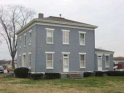
Samuel Augspurger House at Woodsdale | |
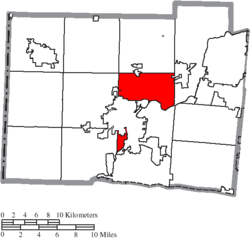 Location of St. Clair Township in Butler County | |
| Coordinates: 39°26′20″N 84°32′10″W / 39.43889°N 84.53611°WCoordinates: 39°26′20″N 84°32′10″W / 39.43889°N 84.53611°W | |
| Country | United States |
| State | Ohio |
| County | Butler |
| Area | |
| • Total | 21.4 sq mi (55.5 km2) |
| • Land | 21.1 sq mi (54.6 km2) |
| • Water | 0.3 sq mi (0.9 km2) |
| Elevation[1] | 627 ft (191 m) |
| Population (2010) | |
| • Total | 6,908 |
| • Density | 328/sq mi (126.5/km2) |
| Time zone | Eastern (EST) (UTC-5) |
| • Summer (DST) | EDT (UTC-4) |
| FIPS code | 39-69498[2] |
| GNIS feature ID | 1085820[1] |
| Website |
stclairtownshipohio |

St. Clair Township, one of thirteen townships in Butler County, Ohio, United States, consists of three disconnected pieces located along the Great Miami River in central Butler County. It had a population of 6,908 at the 2010 census, down from 7,336 in 2000.[3] Exclusive of the village of New Miami and the southern part of the village of Seven Mile, which lie within its borders, the unincorporated portion of St. Clair Township had 4,404 inhabitants in 2010.
History
Creation
One of the original five townships of Butler County, it was erected by the Butler County Court of Quarter Sessions on May 10, 1803, with these boundaries:
- Beginning on the west bank of the Miami at the southwest corner of the fractional township No. 1 of the fourth range west of the Miami; thence north to the northern boundary of the county; thence west to the northwest corner of the county; thence south to the southwest corner of the township No. 4 of the first range west of the Miami; thence east to the Miami; thence northeasterly and northwestwardly up the Miami to the place of beginning.
Reduction
The area of the township has been significantly reduced from the original boundaries. Four new townships were created from it: Milford Township and Wayne Township, both on December 2, 1805; Reily Township on December 7, 1807; and Hanover Township (from parts of St. Clair and Ross townships) on December 2, 1811. What is now Oxford Township was originally within the bounds of St. Clair Township, Oxford having been erected from Milford Township in 1811.
From these reduced borders, which consisted of nineteen whole and nine fractional sections, a substantial area has been withdrawn from the township because of annexations by the city of Hamilton. Most of the area of Hamilton west of the Great Miami River, the township's southern boundary, was originally included in St. Clair Township. In 1857, a paper township, Hamilton, was erected from parts of St. Clair and Fairfield townships.
Name
It is named for General Arthur St. Clair, governor of the Northwest Territory before Ohio's statehood. Statewide, the only other St. Clair Township is located in Columbiana County.
Historic population figures
- 1810—1,180
- 1820—1,307
- 1830—1,834
- 1900—1,388
- 1910—1,955
- 1920—2,161
- 1930—3,225
- 1940—3,828
- 1950—4,950
- 1960—7,011
- 1970—7,952
- 1980—8,223
- 1990—7,670
- 2000—7,336
- 2010—6,908
Geography
Located in the center of the county, it borders the following townships:
- Wayne Township - north
- Madison Township - east
- Fairfield Township - south
- Ross Township - southwest
- Hanover Township - west
- Milford Township - northwest corner
Three unincorporated communities are located in St. Clair Township: Overpeck and Williamsdale in the center, and Woodsdale in the southeast along the border with Madison Township.
Government
The township is governed by a three-member board of trustees, who are elected in November of odd-numbered years to a four-year term beginning on the following January 1. Two are elected in the year after the presidential election and one is elected in the year before it. There is also an elected township fiscal officer,[4] who serves a four-year term beginning on April 1 of the year after the election, which is held in November of the year before the presidential election. Vacancies in the fiscal officership or on the board of trustees are filled by the remaining trustees.
Roads and industry
The principal highways are U.S. Route 127 (the main road between Hamilton and Eaton), and State Routes 128 and 177.
The Miller Brewing Company operates a brewery in the northeast, on the line with Madison Township. The Cincinnati Gas and Electric Company has a generating plant in the township.
References
- 1 2 "US Board on Geographic Names". United States Geological Survey. 2007-10-25. Retrieved 2008-01-31.
- ↑ "American FactFinder". United States Census Bureau. Retrieved 2008-01-31.
- ↑ "Geographic Identifiers: 2010 Demographic Profile Data (G001): St. Clair township, Butler County, Ohio". U.S. Census Bureau, American Factfinder. Retrieved February 21, 2014.
- ↑ §503.24, §505.01, and §507.01 of the Ohio Revised Code. Accessed 4/30/2009.
- Bert S. Barlow, W.H. Todhunter, Stephen D. Cone, Joseph J. Pater, and Frederick Schneider, eds. Centennial History of Butler County, Ohio. Hamilton, Ohio: B.F. Bowen, 1905.
- Jim Blount. The 1900s: 100 Years In the History of Butler County, Ohio. Hamilton, Ohio: Past Present Press, 2000.
- Butler County Engineer's Office. Butler County Official Transportation Map, 2003. Fairfield Township, Butler County, Ohio: The Office, 2003.
- A History and Biographical Cyclopaedia of Butler County, Ohio with Illustrations and Sketches of Its Representative Men and Pioneers. Cincinnati, Ohio: Western Biographical Publishing Company, 1882.
- Ohio. Secretary of State. The Ohio municipal and township roster, 2002-2003. Columbus, Ohio: The Secretary, 2003.
External links
Municipalities and communities of Butler County, Ohio, United States | ||
|---|---|---|
| Cities |  | |
| Villages | ||
| Townships | ||
| CDPs | ||
| Unincorporated communities | ||
| Footnotes | ‡This populated place also has portions in an adjacent county or counties | |