Leynhac
| Leynhac | |
|---|---|
|
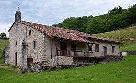
The priory of Our Lady of the Bridge | |
 Leynhac | |
|
Location within Auvergne-Rhône-Alpes region  Leynhac | |
| Coordinates: 44°44′28″N 2°18′03″E / 44.7411°N 2.3008°ECoordinates: 44°44′28″N 2°18′03″E / 44.7411°N 2.3008°E | |
| Country | France |
| Region | Auvergne-Rhône-Alpes |
| Department | Cantal |
| Arrondissement | Aurillac |
| Canton | Maurs |
| Intercommunality | Pays de Maurs |
| Government | |
| • Mayor (2008–2014) | Jacques Caumon |
| Area1 | 27.68 km2 (10.69 sq mi) |
| Population (2008)2 | 352 |
| • Density | 13/km2 (33/sq mi) |
| Time zone | CET (UTC+1) |
| • Summer (DST) | CEST (UTC+2) |
| INSEE/Postal code | 15104 / 15600 |
| Elevation |
275–652 m (902–2,139 ft) (avg. 480 m or 1,570 ft) |
|
1 French Land Register data, which excludes lakes, ponds, glaciers > 1 km² (0.386 sq mi or 247 acres) and river estuaries. 2 Population without double counting: residents of multiple communes (e.g., students and military personnel) only counted once. | |
Leynhac is a commune in the Cantal department in south-central France.
Population
| Historical population | ||
|---|---|---|
| Year | Pop. | ±% |
| 1962 | 580 | — |
| 1968 | 656 | +13.1% |
| 1975 | 609 | −7.2% |
| 1982 | 518 | −14.9% |
| 1990 | 441 | −14.9% |
| 1999 | 386 | −12.5% |
| 2008 | 352 | −8.8% |
See also
References
| Wikimedia Commons has media related to Leynhac. |
This article is issued from Wikipedia - version of the 7/21/2016. The text is available under the Creative Commons Attribution/Share Alike but additional terms may apply for the media files.