Valuéjols
| Valuéjols | ||
|---|---|---|
|
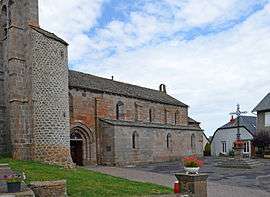
The church of Saint-Saturnin, in Valuéjols | ||
| ||
 Valuéjols | ||
|
Location within Auvergne-Rhône-Alpes region  Valuéjols | ||
| Coordinates: 45°03′14″N 2°56′05″E / 45.0539°N 2.9347°ECoordinates: 45°03′14″N 2°56′05″E / 45.0539°N 2.9347°E | ||
| Country | France | |
| Region | Auvergne-Rhône-Alpes | |
| Department | Cantal | |
| Arrondissement | Saint-Flour | |
| Canton | Saint-Flour-Sud | |
| Intercommunality | Planèze | |
| Government | ||
| • Mayor (2014–2020) | Christophe Vidal | |
| Area1 | 38.51 km2 (14.87 sq mi) | |
| Population (2012)2 | 556 | |
| • Density | 14/km2 (37/sq mi) | |
| Time zone | CET (UTC+1) | |
| • Summer (DST) | CEST (UTC+2) | |
| INSEE/Postal code | 15248 / 15300 | |
| Elevation |
974–1,410 m (3,196–4,626 ft) (avg. 1,064 m or 3,491 ft) | |
|
1 French Land Register data, which excludes lakes, ponds, glaciers > 1 km² (0.386 sq mi or 247 acres) and river estuaries. 2 Population without double counting: residents of multiple communes (e.g., students and military personnel) only counted once. | ||
.svg.png)
Valuéjols is a commune in the département of Cantal in south-central France.
Population
| Historical population | ||
|---|---|---|
| Year | Pop. | ±% |
| 1962 | 922 | — |
| 1968 | 833 | −9.7% |
| 1975 | 696 | −16.4% |
| 1982 | 607 | −12.8% |
| 1990 | 578 | −4.8% |
| 1999 | 525 | −9.2% |
| 2006 | 527 | +0.4% |
| 2012 | 556 | +5.5% |
See also
References
| Wikimedia Commons has media related to Valuéjols. |
This article is issued from Wikipedia - version of the 10/8/2015. The text is available under the Creative Commons Attribution/Share Alike but additional terms may apply for the media files.