Saint-Vincent-de-Salers
| Saint-Vincent-de-Salers | |
|---|---|
|
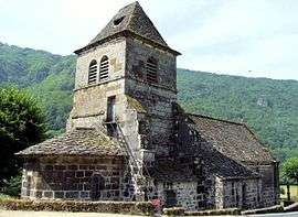
The church of Saint-Vincent, in Saint-Vincent-de-Salers | |
 Saint-Vincent-de-Salers | |
|
Location within Auvergne-Rhône-Alpes region  Saint-Vincent-de-Salers | |
| Coordinates: 45°12′14″N 2°31′57″E / 45.2039°N 2.5325°ECoordinates: 45°12′14″N 2°31′57″E / 45.2039°N 2.5325°E | |
| Country | France |
| Region | Auvergne-Rhône-Alpes |
| Department | Cantal |
| Arrondissement | Mauriac |
| Canton | Salers |
| Government | |
| • Mayor (2008–2014) | Jean Rodde |
| Area1 | 18.87 km2 (7.29 sq mi) |
| Population (2008)2 | 79 |
| • Density | 4.2/km2 (11/sq mi) |
| Time zone | CET (UTC+1) |
| • Summer (DST) | CEST (UTC+2) |
| INSEE/Postal code | 15218 / 15380 |
| Elevation |
575–1,264 m (1,886–4,147 ft) (avg. 740 m or 2,430 ft) |
|
1 French Land Register data, which excludes lakes, ponds, glaciers > 1 km² (0.386 sq mi or 247 acres) and river estuaries. 2 Population without double counting: residents of multiple communes (e.g., students and military personnel) only counted once. | |
Saint-Vincent-de-Salers is a commune in the Cantal department in south-central France.
Population
| Historical population | ||
|---|---|---|
| Year | Pop. | ±% |
| 1962 | 352 | — |
| 1968 | 299 | −15.1% |
| 1975 | 217 | −27.4% |
| 1982 | 168 | −22.6% |
| 1990 | 127 | −24.4% |
| 1999 | 108 | −15.0% |
| 2008 | 79 | −26.9% |
See also
References
| Wikimedia Commons has media related to Saint-Vincent-de-Salers. |
This article is issued from Wikipedia - version of the 2/15/2015. The text is available under the Creative Commons Attribution/Share Alike but additional terms may apply for the media files.