List of Historic Sites of Japan (Toyama)

This list is of the Historic Sites of Japan located within the Prefecture of Toyama.[1]

National Historic Sites

As of 1 August 2014, nineteen sites have been designated as being of national significance, including the Kaga Domain Maeda Clan Graves, which span the prefectural borders with Ishikawa.[2][3][4]

Site Municipality Comments Image Coordinates Type Ref.
Jōbenoma Site
じょうべのま遺跡
Jōbenoma iseki
Nyūzen Heian and later manor 36°57′15″N 137°29′42″E / 36.95419906°N 137.49495892°E / 36.95419906; 137.49495892 (Jōbenoma Site) 6 968
Yasuda Castle Site
安田城
Yasuda-jō ato
Toyama
36°40′48″N 137°09′38″E / 36.68000181°N 137.16043376°E / 36.68000181; 137.16043376 (Yasuda Castle Site) 2 969
Etchū Gokayama Suganuma Hamlet
越中五箇山菅沼集落
Etchū Gokayama Suganuma shūraku
Nanto forms part of the UNESCO World Heritage Site Historic Villages of Shirakawa-gō and Gokayama[5]
36°24′15″N 136°53′12″E / 36.40421889°N 136.88665288°E / 36.40421889; 136.88665288 (Etchū Gokayama Suganuma Hamlet) 6 962
Etchū Gokayama Ainokura Hamlet
越中五箇山相倉集落
Etchū Gokayama Ainokura shūraku
Nanto forms part of the UNESCO World Heritage Site Historic Villages of Shirakawa-gō and Gokayama[5]
36°25′33″N 136°56′07″E / 36.42571158°N 136.93529774°E / 36.42571158; 136.93529774 (Etchū Gokayama Ainokura Hamlet) 6 961
Ōzuka-Senbōyama Sites
王塚・千坊山遺跡群
Ōzuka-Senbōyama iseki-gun
Toyama 36°39′38″N 137°07′01″E / 36.66066344°N 137.11689115°E / 36.66066344; 137.11689115 (Ōzuka-Senbōyama Sites) 1 959
Kushidashin Site
串田新遺跡
Kushidashin iseki
Imizu 36°41′21″N 137°02′29″E / 36.68904755°N 137.04150035°E / 36.68904755; 137.04150035 (Kushidashin Site) 1 967
Takase Site
高瀬遺跡
Takase iseki
Nanto City early Heian shōen[6] 36°33′53″N 136°56′58″E / 36.56475691°N 136.94941773°E / 36.56475691; 136.94941773 (Takase Site) 6 963
Sakuradani Kofun
桜谷古墳
Sakuradani kofun
Takaoka 36°49′00″N 137°01′56″E / 36.8165862°N 137.03209723°E / 36.8165862; 137.03209723 (Sakuradani Kofun) 1 952
Kosugimaruyama Site
小杉丸山遺跡
Kosugimaruyama iseki
Imizu 36°41′47″N 137°03′55″E / 36.69626753°N 137.06534438°E / 36.69626753; 137.06534438 (Kosugimaruyama Site) 1 972
Kamiichi Kurokawa Sites
上市黒川遺跡群
Kamiichi Kurokawa iseki-gun
Kamiichi designation includes the sites of the Ennenjiyama Sutra Mound (円念寺山経塚), Kurokawa Ueyama Graves (黒川上山墓跡), and Shingō-ji (伝真興寺跡) 36°42′53″N 137°24′09″E / 36.71477651°N 137.40260899°E / 36.71477651; 137.40260899 (Kamiichi Kurokawa Sites) 3, 7 00003468
Masuyama Castle Site
増山城
Masuyama-jō ato
Tonami
36°39′08″N 137°02′36″E / 36.65227717°N 137.04323643°E / 36.65227717; 137.04323643 (Masuyama Castle Site) 2 00003642
Ōiwa Nissekiji Stone Buddhas
大岩日石寺石仏
Ōiwa Nissekiji sekibutsu
Kamiichi 36°39′44″N 137°23′28″E / 36.66212994°N 137.39110523°E / 36.66212994; 137.39110523 (Ōiwa Nissekiji Stone Buddhas) 3 951
Ōzakai Caves Main Cave
大境洞窟住居跡
Ōzakai dōkutsu jūkyo ato
Himi
36°55′22″N 137°01′49″E / 36.92282433°N 137.03024392°E / 36.92282433; 137.03024392 (Ōzakai Caves) 1 945
Asahi Shell Mound
朝日貝塚
Asahi kaizuka
Himi 36°50′55″N 136°59′04″E / 36.84849153°N 136.98434353°E / 36.84849153; 136.98434353 (Asahi Shell Mound) 1 944
Sugusaka Site
直坂遺跡
Sugusaka iseki
Toyama 36°33′35″N 137°13′12″E / 36.5595924°N 137.22005713°E / 36.5595924; 137.22005713 (Sugusaka Site) 1 970
Fudōdō Site
不動堂遺跡
Fudōdō iseki
Asahi 36°55′15″N 137°33′13″E / 36.92085631°N 137.55369753°E / 36.92085631; 137.55369753 (Fudōdō Site) 1 966
Kitadai Site
北代遺跡
Kitadai iseki
Toyama 36°43′03″N 137°11′10″E / 36.71743416°N 137.18618907°E / 36.71743416; 137.18618907 (Kitadai Site) 1 971
Yanaidanu-no-Oyama Kofun
柳田布尾山古墳
Yanaidanu-no-Oyama kofun
Himi
36°49′24″N 136°59′27″E / 36.82343172°N 136.99093037°E / 36.82343172; 136.99093037 (Yanaidanu-no-Oyama Kofun) 1 3278
Kaga Domain Maeda Clan Graves
加賀藩主前田家墓所
Kaga-han-shu Maeda-ke bosho
Takaoka designation includes an area of Kanazawa in Ishikawa Prefecture
36°44′15″N 137°01′23″E / 36.737577°N 137.022986°E / 36.737577; 137.022986 (Kaga Domain Maeda Clan Graves) 7 00003621

Prefectural Historic Sites

As of 1 May 2014, thirty-one sites have been designated as being of prefectural importance.[4][7]

Site Municipality Comments Image Coordinates Type Ref.
Ao Castle Site
阿尾城跡
Ao-jō ato
Himi 36°52′48″N 136°59′27″E / 36.879869°N 136.990757°E / 36.879869; 136.990757 (Ao Castle Site)
Sakai Ichirizuka
境一里塚
Sakai ichirizuka
Asahi 36°58′35″N 137°37′28″E / 36.976265°N 137.624407°E / 36.976265; 137.624407 (Sakai Milestone)
Miyazaki Castle Site
宮崎城
Miyazaki-jō ato
Himi 36°57′47″N 137°35′08″E / 36.963026°N 137.585553°E / 36.963026; 137.585553 (Miyazaki Castle Site)
Chigozuka
稚児塚
Chigozuka
Tateyama 36°41′34″N 137°19′08″E / 36.692666°N 137.318759°E / 36.692666; 137.318759 (Chigozuka)
Jōgahira Cave Tombs
城ガ平横穴古墳
Jōgahira ōketsu kofun-gun
Takaoka 36°44′28″N 136°55′39″E / 36.741240°N 136.927532°E / 36.741240; 136.927532 (Jōgahira Cave Tombs)
Takaoka Castle Site
高岡城
Takaoka-jō ato
Takaoka 36°44′57″N 137°01′14″E / 36.749167°N 137.020556°E / 36.749167; 137.020556 (Takaoka Castle Site)
Ōzuka Kofun
大塚古墳
Ōzuka kofun
Imizu 36°42′03″N 137°03′26″E / 36.700701°N 137.057233°E / 36.700701; 137.057233 (Ōzuka Kofun)
Sakuratōge Site
桜峠遺跡
Sakuratōge iseki
Uozu 36°49′29″N 137°28′25″E / 36.824814°N 137.473640°E / 36.824814; 137.473640 (Sakuratōge Site)
Matuskura Castle Site
松倉城跡
Matuskura-jō ato
Uozu 36°45′44″N 137°26′27″E / 36.762194°N 137.440861°E / 36.762194; 137.440861 (Matuskura Castle Site)
Kitano Stone Buddha Niche
北野の石龕
Kitano no sekigan
Kurobe 36°53′30″N 137°26′54″E / 36.891549°N 137.448428°E / 36.891549; 137.448428 (Kitano Stone Buddha Niche)
Gorintō
嘉暦四歳銘五輪石塔
Karyaku yonsai mei gorin sekitō
Kurobe inscribed Karyaku 4 (1329) 36°53′19″N 137°25′56″E / 36.888648°N 137.432334°E / 36.888648; 137.432334 (Gorintō)
Kareisawa Stone Buddhas
嘉例沢の石仏
Kareisawa sekibutsu
Kurobe 36°49′42″N 137°32′04″E / 36.828249°N 137.534462°E / 36.828249; 137.534462 (Kareisawa Stone Buddhas)
Etchū Kokubun-ji Site
越中国分寺跡
Etchū Kokubunji ato
Takaoka provincial temple of Etchū Province 36°47′52″N 137°02′57″E / 36.797902°N 137.049197°E / 36.797902; 137.049197 (Etchū Kokubunji Site)
Chokushizuka
勅使塚
Chokushizuka
Toyama 36°39′38″N 137°07′01″E / 36.660570°N 137.116842°E / 36.660570; 137.116842 (Chokushizuka)
Sakai Barrier Site
境関跡
Sakai seki ato
Asahi 36°58′37″N 137°37′33″E / 36.977°N 137.625833°E / 36.977; 137.625833 (Sakai Barrier Site)
Inotani Barrier Site
猪谷関跡
Inotani seki ato
Toyama 36°28′17″N 137°14′22″E / 36.471304°N 137.239323°E / 36.471304; 137.239323 (Inotani Barrier Site)
Kifune Castle Site
木舟城
Kifune-jō ato
Takaoka 36°41′18″N 136°54′50″E / 36.688250°N 136.913972°E / 36.688250; 136.913972 (Kifune Castle Site)
Ikuji Battery
生地台場
Ikuji daiba
Kurobe 36°53′57″N 137°24′39″E / 36.899198°N 137.410807°E / 36.899198; 137.410807 (Ikuji Battery)
Miyanaga Jūzaemon Grave
宮永十佐エ門の墓
Miyanaga Jūzaemon no haka
Oyabe 36°36′16″N 136°53′40″E / 36.604538°N 136.894391°E / 36.604538; 136.894391 (Miyanaga Jūzaemon Grave)
Zuiryū-ji Stone Tombs
瑞龍寺の石廟
Zuiryūji no sekibyō
Takaoka 36°44′08″N 137°00′38″E / 36.735595°N 137.010504°E / 36.735595; 137.010504 (Zuiryūji Stone Tombs)
Aimotoshin Site
愛本新遺跡
Aimotoshin iseki
Kurobe 36°53′14″N 137°32′31″E / 36.887241°N 137.541962°E / 36.887241; 137.541962 (Aimotoshin Site)
Hongō Site
本江遺跡
Hongō iseki
Namerikawa 36°43′38″N 137°23′05″E / 36.727328°N 137.384773°E / 36.727328; 137.384773 (Hongō Site)
Takase Site (Anada District)
高瀬遺跡 (穴田地区)
Takase iseki (Anada chiku)
Nanto 36°33′54″N 136°56′58″E / 36.564875°N 136.949472°E / 36.564875; 136.949472 (Takase Site (Anada District))
Hamayama Jewelry Workshop
浜山玉つくり遺跡
Hamayama tama-tsukuri iseki
Asahi Kofun-period workshop for magatama, cylindrical beads, and other jewels[8] 36°58′13″N 137°36′06″E / 36.970347°N 137.601700°E / 36.970347; 137.601700 (Hamayama Jewelry Workshop)
Nakayamaminami Site
中山南遺跡
Nakayamaminami iseki
Imizu 36°42′19″N 137°06′32″E / 36.705199°N 137.108871°E / 36.705199; 137.108871 (Nakayamaminami Site)
Mizukamitani Site
水上谷遺跡
Mizukamitani iseki
Imizu 36°39′56″N 137°04′03″E / 36.665648°N 137.067581°E / 36.665648; 137.067581 (Mizukamitani Site)
Kamakusa No.1 Kiln Site
金草第一古窯跡
Kamakusa daiichi furu kama ato
Toyama 36°41′51″N 137°09′21″E / 36.697483°N 137.155745°E / 36.697483; 137.155745 (Kamakusa No.1 Kiln Site)
Higashi-Kuromaki-Ueno Site
東黒牧上野遺跡
Higashi-Kuromaki-Ueno iseki
Toyama 36°36′09″N 137°16′40″E / 36.602420°N 137.277775°E / 36.602420; 137.277775 (Higashi-Kuromaki-Ueno Site)
Kakoiyama Site
囲山遺跡
Kakoiyama iseki
Imizu 36°42′33″N 137°05′24″E / 36.709044°N 137.090106°E / 36.709044; 137.090106 (Kakoiyama Site)
Wakamiya Kofun
若宮古墳
Wakamiya kofun
Oyabe 36°39′52″N 136°51′06″E / 36.664340°N 136.851733°E / 36.664340; 136.851733 (Wakamiya Kofun)
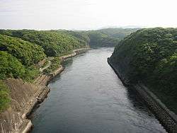
Shōmyō Falls Basin
称名滝とその流域
Shōmyō-daki to sono ryūiki
Tateyama the falls are a national Place of Scenic Beauty and Natural Monument and a locus of Shugendō practice[9][10] 36°34′33″N 137°31′36″E / 36.57584479°N 137.52670587°E / 36.57584479; 137.52670587 (Shōmyō Falls Basin)

Municipal Historic Sites

As of 1 May 2014, a further one hundred and eighty-five sites have been designated as being of municipal importance.[4][11]

See also

References

Wikimedia Commons has media related to National historic sites in Toyama prefecture.
  1. "Cultural Properties for Future Generations". Agency for Cultural Affairs. Retrieved 6 August 2014.
  2. 史跡名勝天然記念物 [Number of Monuments of Japan by Prefecture] (in Japanese). Agency for Cultural Affairs. 1 August 2014. Retrieved 6 August 2014.
  3. "Database of National Cultural Properties: 史跡名勝天然記念物 (史跡, 特別史跡 富山県 2県以上)" (in Japanese). Agency for Cultural Affairs. Retrieved 6 August 2014.
  4. 1 2 3 富山県指定文化財 [Cultural Properties of Toyama Prefecture] (in Japanese). Toyama Prefecture. 18 May 2007. Retrieved 6 August 2014.
  5. 1 2 "Historic Villages of Shirakawa-go and Gokayama". UNESCO. Retrieved 19 June 2012.
  6. 史跡公園「高瀬遺跡」 [Historic Park "Takase Site"] (in Japanese). Nanto City. Retrieved 19 June 2012.
  7. 都道府県別指定等文化財件数(都道府県分) [Number of Prefectural Cultural Properties by Prefecture] (in Japanese). Agency for Cultural Affairs. 1 May 2014. Retrieved 6 August 2014.
  8. 玉つくりの遺跡 [Jewelry Workshop Site] (in Japanese). Toyama Prefecture. Retrieved 29 June 2012.
  9. 称名滝 [Shōmyō Falls] (in Japanese). Agency for Cultural Affairs. Retrieved 29 June 2012.
  10. 称名滝とその流域 [Shōmyō Falls Basin] (in Japanese). MLIT Hokuriku Regional Development Bureau. Retrieved 29 June 2012.
  11. 都道府県別指定等文化財件数(市町村分) [Number of Municipal Cultural Properties by Prefecture] (in Japanese). Agency for Cultural Affairs. 1 May 2014. Retrieved 6 August 2014.
This article is issued from Wikipedia - version of the 12/19/2015. The text is available under the Creative Commons Attribution/Share Alike but additional terms may apply for the media files.