Lochem
| Lochem | |||
|---|---|---|---|
| Municipality and city | |||
|
Street in Lochem | |||
| |||
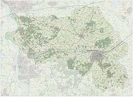
.svg.png) Location in Gelderland | |||
| Coordinates: 52°10′N 6°25′E / 52.167°N 6.417°ECoordinates: 52°10′N 6°25′E / 52.167°N 6.417°E | |||
| Country | Netherlands | ||
| Province | Gelderland | ||
| Government[1] | |||
| • Body | Municipal council | ||
| • Mayor | Sebastiaan van ’t Erve (GL) | ||
| Area[2] | |||
| • Total | 215.94 km2 (83.37 sq mi) | ||
| • Land | 213.20 km2 (82.32 sq mi) | ||
| • Water | 2.74 km2 (1.06 sq mi) | ||
| Elevation[3] | 14 m (46 ft) | ||
| Population (May 2014)[4] | |||
| • Total | 33,227 | ||
| • Density | 156/km2 (400/sq mi) | ||
| Demonym(s) | Lochemer | ||
| Time zone | CET (UTC+1) | ||
| • Summer (DST) | CEST (UTC+2) | ||
| Postcode | 7210–7218, 7240–7245 | ||
| Area code | 0573, 0575 | ||
| Website |
lochem | ||


Lochem (![]() pronunciation ) is a municipality and a city in the eastern Netherlands. On 1 January 2005, the municipality merged with the municipality of Gorssel.
pronunciation ) is a municipality and a city in the eastern Netherlands. On 1 January 2005, the municipality merged with the municipality of Gorssel.
Population centres
Small hamlets are printed in italics.
Formerly in Gorssel:
- Almen
- Eefde (immediately north of Zutphen)
- Epse ( near the A1{Amsterdam - Berlin} motorway)
- Gorssel
- Harfsen
The city of Lochem
Lochem, 18 km (11 mi) east of Zutphen, received city rights in 1233. Until the 17th century, it was often besieged and burnt down. After 1700, it became a small market town for the farmers in its surroundings.
The village of Laren (Gelderland) has a castle called Verwolde. In summer, guided tours of this castle are organized for tourists. On its estate there is a tree, said to be the thickest tree in the Netherlands ( "de dikke boom van Verwolde").
Transport
Lochem railway station - Railway Zutphen to Oldenzaal (line 73): Zutphen - Lochem - Goor (mun. Hof van Twente) - Delden (ditto) - Hengelo - Oldenzaal.
Photos
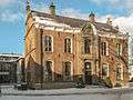 Lochem, former town hall
 Lochem, church: de Gudulakerk
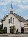 Lochem, church: de Witte Kerk
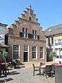 Lochem, monumental house on the Markt
 Lochem, monumental house at 't Ei
 Lochem, river (de Berkel) from de Graaf Ottoweg
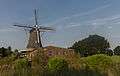 Zwiep, windmill: de Zwiepse Molen
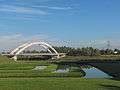 Lochem, bridge across Twentekanaal
References
- ↑ "Burgemeester van 't Erve" [Mayor van 't Erve] (in Dutch). Gemeente Lochem. Retrieved 17 June 2014.
- ↑ "Kerncijfers wijken en buurten" [Key figures for neighbourhoods]. CBS Statline (in Dutch). CBS. 2 July 2013. Retrieved 12 March 2014.
- ↑ "Postcodetool for 7241AA". Actueel Hoogtebestand Nederland (in Dutch). Het Waterschapshuis. Retrieved 17 June 2014.
- ↑ "Bevolkingsontwikkeling; regio per maand" [Population growth; regions per month]. CBS Statline (in Dutch). CBS. 26 June 2014. Retrieved 24 July 2014.
External links
 Media related to Lochem at Wikimedia Commons
- Official website
 |
Deventer (OV), Rijssen-Holten (OV) | Hof van Twente (OV) | | |
| Voorst | |
|||
| ||||
| | ||||
| Zutphen, Bronckhorst | Berkelland |
