Wageningen
| Wageningen | |||
|---|---|---|---|
| Municipality | |||
|
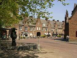
Market Square in Wageningen | |||
| |||
| Motto: City of Life Sciences | |||
.svg.png) Location in Gelderland | |||
| Coordinates: 51°58′N 5°40′E / 51.967°N 5.667°ECoordinates: 51°58′N 5°40′E / 51.967°N 5.667°E | |||
| Country | Netherlands | ||
| Province | Gelderland | ||
| City right | 12 June 1263[1] | ||
| Government[2] | |||
| • Body | Municipal council | ||
| • Mayor | Geert van Rumund (PvdA) | ||
| Area[3] | |||
| • Total | 32.36 km2 (12.49 sq mi) | ||
| • Land | 30.49 km2 (11.77 sq mi) | ||
| • Water | 1.87 km2 (0.72 sq mi) | ||
| Elevation[4] | 9 m (30 ft) | ||
| Population (May 2014)[5] | |||
| • Total | 37,434 | ||
| • Density | 1,228/km2 (3,180/sq mi) | ||
| Demonym(s) | Wageninger | ||
| Time zone | CET (UTC+1) | ||
| • Summer (DST) | CEST (UTC+2) | ||
| Postcode | 6700–6709 | ||
| Area code | 0317 | ||
| Website |
www | ||

Wageningen (Dutch pronunciation: [ˈʋaːɣənɪŋə(n)]) is a municipality and a historic town in the central Netherlands, in the province of Gelderland. It is famous for Wageningen University, which specialises in life sciences. The municipality had a population of 37,434 in 2014, of which many thousands are students from over 150 countries.
Geography
Wageningen is situated on the north bank of the Nederrijn (the Dutch portion of the Lower Rhine) part of the Gelderse valley (Dutch: Gelderse Vallei) and the Veluwe, of which the southwest hill is called the Wageningse Berg. Wageningen can be reached by car from highways A12 via the N781, A15 via the N233 and N225, and A50 via the N225, and from the Ede-Wageningen railway station via a 15-minute bus drive to the Wageningen central terminal (see below).[6],[7]
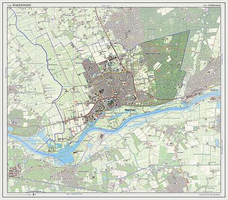
Topographic map of the municipality of Wageningen, July 2013 (click to enlarge)
History

The oldest known settlements in the Wageningen area were located north of today's town centre.[1] They were mentioned as early as 828. During the early Middle Ages a small church was built on the hill east of the town. Several wood farms have been found near the top of the hill. In the twelfth century people settled at what is currently the Bergstraat. Close to Hotel de Wereld a stone floor has been found dating back to this period. After the construction of a dike to protect the city from the acidic water from the moors that then occupied the Gelderse Vallei (the current Hoogstraat), the oldest part of the present city was built to the south. The parts of the city north of the Hoogstraat were built later. Wageningen received city rights in 1263.[1] The city was protected by a city wall and a moat, and in 1526 a castle was built. The castle was dismantled during the 18th century, but the foundations of three of the towers and part of the wall remain visible today.
The people, city, and institutions of Wageningen suffered greatly during World War II. The central part of Wageningen was destroyed by artillery fire soon after the German invasion of the country in May 1940. The town is also famous for its role at the end of the war: Wageningen was the site of the surrender of German General Johannes Blaskowitz to Canadian General Charles Foulkes on May 5, 1945, officially ending the war in the Netherlands. The generals negotiated the terms of surrender in the Hotel de Wereld, near the center of the city.[1] Now, each year on the 5th of May, Liberation Day in the Netherlands, Wageningen hosts a large festival to celebrate the liberation. On this occasion, veteran soldiers parade through the city and are honoured for their service, and around 120,000 people[8] visit the pop-podia around the city.[9]
Education & research
In 1918 the town acquired its first institution of higher education, the Landbouwhogeschool Nederland (Netherlands Agricultural College), which was based on the previous agricultural college founded in 1876, and which later became Wageningen University.[10] This initiated the development from a small historical town into a modern technological community, a process which still continues today.
Wageningen University and Research Centre (WUR), including associated institutes, now employs about 7400 people.
Today, Wageningen is also the central city in Food Valley,[11] the Dutch food & nutrition cluster concentrated around WUR, and comprising many institutes, companies and state-of-the-art facilities in the food & nutrition field. Food Valley is regarded as the largest food & nutrition Research & Development cluster in the world. One such firm, Keygene, a biotechnology company in Wageningen developed AFLP in the early 1990s and collaborated with Beijing Genomics Institute to sequence the entire genome of Brassica napus.
Sports teams
The city had its own professional football (soccer) club, FC Wageningen, which won the KNVB-beker (KNVB Cup) twice.[12][13] The club went bankrupt in 1992 and played its last match in May 1992 against NAC Breda.
Traffic & transport
Wageningen is situated on the N225 provincial road, between Driebergen and Arnhem. The N781 provincial road connects Wageningen to the A12 national highway, to the north of the city. A small ferry (for cars, bikes, and pedestrians) crosses the Nederrijn to the south of the city, at Lexkesveer; from there, drivers can connect to the A15 national highway, via the N836 provincial road.
Several firms provide public bus service in and to Wageningen. From the Wageningen central bus terminal, lines connect to Rhenen, Tiel, Veenendaal, Utrecht, Oosterbeek, and Arnhem, and the Ede-Wageningen railway station. Further connections via bus, including to the Hoge Veluwe National Park and the Kröller-Müller Museum, also may be made at the Ede-Wageningen station. Bus service includes the following:[14]
| Line | Route | Carrier | Details |
|---|---|---|---|
| 44 | Wageningen – Rhenen NS – Kesteren NS – Lienden - Maurik - Tiel NS | Arriva | |
| 45 | Wageningen – Rhenen NS – Kesteren NS – Ochten - Tiel NS | Arriva | |
| 50 | Wageningen – Rhenen Station NS – Els – Amerongen – Leersum – Doorn – Driebergen-Zeist NS – Utrecht CS | Connexxion | |
| 51 | Wageningen – Renkum – Heelsum – Doorwerth – Heveadorp – Oosterbeek – Arnhem CS | Breng | |
| 352 | Wageningen – Renkum – Heelsum – Oosterbeek – Arnhem CS | Breng | |
| 53 | Wageningen – Renkum – Heteren – Driel – NS Station Arnhem Zuid – Winkelcentrum Kronenburg | Breng | |
| 80 | Wageningen – Rhenen Station NS – Veenendaal centrum – Veenendaal de Klomp NS – Renswoude – Scherpenzeel – Woudenberg – Leusden – Amersfoort CS | Connexxion | |
| 84 | Wageningen – Wageningen Campus – Gelderse Vallei Ziekenhuis – Ede-Wageningen NS | Syntus Gelderland | Part of the Valleilijn |
| 86 | Wageningen – Bennekom – Ede-Wageningen NS | Syntus Gelderland | |
| 88 | Wageningen – Wageningen Hoevestein - Gelderse Vallei Ziekenhuis – Ede-Wageningen NS | Syntus Gelderland | Part of the Valleilijn |
| N52 - Night bus | Arnhem Willemsplein – Wageningen | Breng | Only Saturday night |
Politics
Municipal council
Composition of the Wageningen municipal council since 1994:
| Municipal council seats | |||||||||||||||
|---|---|---|---|---|---|---|---|---|---|---|---|---|---|---|---|
| Party | 1994 | 1998 | 2002 | 2006 | 2010 | 2014[15] | |||||||||
| PvdA | 6 | 7 | 6 | 7 | 4 | 3 | |||||||||
| GroenLinks | 5 | 6 | 6 | 4 | 5 | 5 | |||||||||
| VVD | 3 | 4 | 4 | 3 | 3 | 2 | |||||||||
| CDA | 4 | 3 | 4 | 3 | 3 | 2 | |||||||||
| D66 | 4 | 2 | 1 | 2 | 6 | 5 | |||||||||
| Wageningen City Party | - | - | 1 | 2 | 2 | 5 | |||||||||
| SP | - | - | - | 3 | 1 | 2 | |||||||||
| ChristenUnie | - | 1 | 1 | 1 | 1 | 1 | |||||||||
| Other | 1 | - | - | - | - | - | |||||||||
| Total | 23 | 23 | 25 | 25 | 25 | 25 | |||||||||
Mayor
Wageningen's mayor, Geert van Rumund (PvdA), has served since 1 November 2005.
Notable residents
Notable people from Wageningen include:
- Johannes de Raey (born 1622), philosopher
- August Falise (born 1875) sculptor [16]
- Li Edelkoort (born 1950), designer and trend forecaster [17]
- Ed van Es (born 1959), water polo player
- Eline Flipse (born 1954), film director
- Aletta van Manen (born 1958), field hockey defender
- Annelies Maas (born 1960), freestyle swimmer
- Jacqueline Toxopeus (born 1964), field hockey goalkeeper [18]
- Alexander Pechtold (born 1965), politician and Parliamentary Leader of the Democrats 66 lives in Wageningen [19]
- Bart Voskamp (born 1968), road bicycle racer
- Annemiek van Vleuten (born 1982), road bicycle racer
- Lisa Hordijk (born 1987), winner of the second season of talent show X Factor.
- Jeroen Dijsselbloem (born 1966), minister van Financiën, the president of the Eurogroup since 21 January 2013, and president of the Board of Governors of the European Stability Mechanism (ESM) since 11 February 2013.
Places of interest
(Including nearby)
- International Club Association [20]
- Airborne Museum 'Hartenstein', Oosterbeek
- Botanical Gardens in Wageningen [21]
- De Casteelse Poort Museum [22]
- Het Depot Museum [23]
- Hoge Veluwe National Park, Ede
- Hotel de Wereld
- Kröller-Müller Museum, Ede/Otterlo
- Netherlands Open Air Museum, Arnhem
- Ouwehands Zoo, Rhenen [24]
- Wageningen University Campus [25]
Twin towns
Wageningen has two twin towns: Gödöllő (Hungary), and Mörfelden-Walldorf (Germany). The city has a project relation with the towns: Zhangzhou (China) and Ndiza (Rwanda).[26]
Gallery
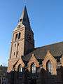 Main church of Wageningen
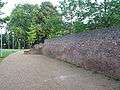 Old city ruins of the castle and city walls
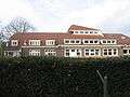 Schip van Blauw
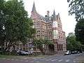 't Venster
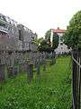 Jewish graveyard
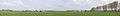 Panorama of the north side of Wageningen
 Panorama of the Rhine river in Wageningen
See also
References
- 1 2 3 4 "History of Wageningen". Casteelsepoort.nl. Retrieved 28 November 2012.
- ↑ "Burgemeester Geert van Rumund" [Mayor Geert van Rumund] (in Dutch). Gemeente Wageningen. Retrieved 21 July 2014.
- ↑ "Kerncijfers wijken en buurten" [Key figures for neighbourhoods]. CBS Statline (in Dutch). CBS. 2 July 2013. Retrieved 12 March 2014.
- ↑ "Postcodetool for 6701CZ". Actueel Hoogtebestand Nederland (in Dutch). Het Waterschapshuis. Retrieved 21 July 2014.
- ↑ "Bevolkingsontwikkeling; regio per maand" [Population growth; regions per month]. CBS Statline (in Dutch). CBS. 26 June 2014. Retrieved 24 July 2014.
- ↑ "Wageningen in Gelderland, The Netherlands". maps.google.nl. Retrieved 28 November 2012.
- ↑ "Wageningen". OpenStreetMap.org. Retrieved 28 November 2012.
- ↑ "Bevrijdingsdag Wageningen soepel verlopen" (in Dutch). www.omroepgelderland.nl. 6 May 2012. Retrieved 28 November 2012.
- ↑ "4 and 5 may Wageningen" (in Dutch). www.4en5meiwageningen.nl. Retrieved 28 November 2012.
- ↑ "Historie van Wageningen UR" (in Dutch). www.wageningenur.nl. Retrieved 28 November 2012.
- ↑ "Welcome to Food Valley!". foodvalley.nl. Retrieved 28 November 2012.
- ↑ "Historie - Voetbal" (in Dutch). www.stadiondewageningseberg.nl. Retrieved 28 November 2012.
- ↑ Bor, Rien (2001). De Onneembare Vesting; de historie van het betaald voetbal op De Wageningse Berg 1954 -1992.
- ↑ "Openbaar vervoer" (in Dutch). www.wageningen.nl. Retrieved 28 November 2012.
- ↑ (Dutch) Definitieve uitslag gemeenteraadsverkiezingen Wageningen 19 maart 2014 on Wageningen.nl
- ↑ "August Falise (1875-1936)". Geldersepoort.nl. Retrieved 28 November 2012.
- ↑ "lidewij edelkoort". Edelkoort.com. Retrieved 28 November 2012.
- ↑ "Jacqueline Toxopeus". www.sports-reference.com. Retrieved 28 November 2012.
- ↑ "Drs. A. (Alexander) Pechtold". parlement.com. Retrieved 28 November 2012.
- ↑ http://newinternationalclub.wix.com/icainternationalclub
- ↑ http://www.botanischetuinen.wur.nl
- ↑ http://www.casteelsepoort.nl/uk/default.aspx
- ↑ http://www.hetdepot.nl/nl/home
- ↑ http://www.ouwehand.nl/Basis.aspx?Tid=168&Lid=222&Lit=TEKST&Stijl=02&Sid=808
- ↑ http://www.wageningencampus.wur.nl/UK/campus_overview/
- ↑ (Dutch) Evaluatierapport stedenbanden
External links
 Media related to Wageningen at Wikimedia Commons
![]() Wageningen travel guide from Wikivoyage
Wageningen travel guide from Wikivoyage
- (Dutch) Official website
 |
Ede | | ||
| Rhenen (UT) | |
Renkum | ||
| ||||
| | ||||
| Nederrijn Neder-Betuwe |
|
Nederrijn Overbetuwe |
