Nunspeet
| Nunspeet | |||
|---|---|---|---|
| Municipality | |||
|
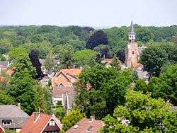
Skyline of Nunspeet | |||
| |||
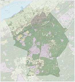
.svg.png) Location in Gelderland | |||
| Coordinates: 52°23′N 5°47′E / 52.383°N 5.783°ECoordinates: 52°23′N 5°47′E / 52.383°N 5.783°E | |||
| Country | Netherlands | ||
| Province | Gelderland | ||
| Government[1] | |||
| • Body | Municipal council | ||
| • Mayor | Breunis van de Weerd (CDA) | ||
| Area[2] | |||
| • Total | 129.53 km2 (50.01 sq mi) | ||
| • Land | 128.79 km2 (49.73 sq mi) | ||
| • Water | 0.74 km2 (0.29 sq mi) | ||
| Elevation[3] | 8 m (26 ft) | ||
| Population (May 2014)[4] | |||
| • Total | 26,704 | ||
| • Density | 207/km2 (540/sq mi) | ||
| Demonym(s) | Nunspeter | ||
| Time zone | CET (UTC+1) | ||
| • Summer (DST) | CEST (UTC+2) | ||
| Postcode | 8070–8077 | ||
| Area code | 0341, 0577 | ||
| Website |
www | ||

Nunspeet (![]() pronunciation ) is a municipality and town in the central Netherlands. It has been an agricultural site since prehistoric times. The municipality contains a number of villages, namely Hulshorst, Elspeet, and Vierhouten. Nunspeet has a vivid historical foundation, called Nuwenspete.[5] In 1973 Nunspeet became a separate municipality after having been part of Ermelo before.
pronunciation ) is a municipality and town in the central Netherlands. It has been an agricultural site since prehistoric times. The municipality contains a number of villages, namely Hulshorst, Elspeet, and Vierhouten. Nunspeet has a vivid historical foundation, called Nuwenspete.[5] In 1973 Nunspeet became a separate municipality after having been part of Ermelo before.
Recreation
Nunspeet is a popular tourist area because it is surrounded by woods, holiday resorts, and has a town center which is located around the main market square.
Nunspeet is situated on the shore of the Veluwemeer (Veluwe lake) which makes it popular for water leisure. There is also a small lake called "de Zandenplas" which is a popular recreational area in wooded sandy terrain.
Other tourist attractions include the weekly market and the town festival, De nacht van Nunspeet (Nunspeet Night) and the Eibertjesmarkt (Eibertjes market), as well as an annual sporting event called "de Keiler".
Population centres
- Nunspeet
- Elspeet
- Hulshorst
- Vierhouten
Gallery
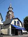 Reformed church in Nunspeet
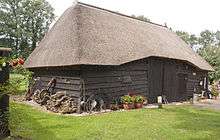 Wooden cattle barn, early 20th century in Nunspeet
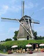 "De Duif" windmill, a beltmolen in Nunspeet
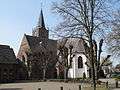 Church in Elspeet
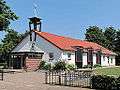 Reformed chapel in Hulshorst
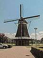 Windmill (molen de Maagd) in Hulshorst
Transportation
- Railway station: Nunspeet
See also
References
- ↑ "Samenstelling" [Members] (in Dutch). Gemeente Nunspeet. Retrieved 14 July 2014.
- ↑ "Kerncijfers wijken en buurten" [Key figures for neighbourhoods]. CBS Statline (in Dutch). CBS. 2 July 2013. Retrieved 12 March 2014.
- ↑ "Postcodetool for 8071GJ". Actueel Hoogtebestand Nederland (in Dutch). Het Waterschapshuis. Retrieved 14 July 2014.
- ↑ "Bevolkingsontwikkeling; regio per maand" [Population growth; regions per month]. CBS Statline (in Dutch). CBS. 26 June 2014. Retrieved 24 July 2014.
- ↑ nuwenspete.nl
External links
 Media related to Nunspeet at Wikimedia Commons
- Official website
 |
Dronten (FL) Veluwemeer |
Elburg | | |
| Harderwijk | |
Epe | ||
| ||||
| | ||||
| Ermelo | Apeldoorn |
