Lonavla
| Lonavala लोणावळा | |
|---|---|
| Hill station | |
|
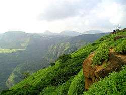
View of Western Ghats near Lonavala | |
 Lonavala | |
| Coordinates: 18°44′53″N 73°24′26″E / 18.74806°N 73.40722°ECoordinates: 18°44′53″N 73°24′26″E / 18.74806°N 73.40722°E | |
| Country |
|
| State | Maharashtra |
| District | Pune |
| Area | |
| • Total | 38 km2 (15 sq mi) |
| Elevation | 624 m (2,047 ft) |
| Population (2001) | |
| • Total | 55,652 |
| • Density | 1,464/km2 (3,790/sq mi) |
| Languages | |
| • Official | Marathi |
| Time zone | IST (UTC+5:30) |
| PIN | 410401 |
| Telephone code | 02114 |
| Vehicle registration | MH 11, MH 14 |
Lonavla ![]() pronunciation officially Lonavala is a town and a hill station Municipal Council in Pune district in the Indian State of Maharashtra.[1] It is about 64 kilometres (40 mi) from the city of Pune and 96 kilometres (60 mi) from the city of Mumbai. It is known for its production of the hard candy chikki[2] and is also a major stop on the railway line connecting Mumbai and Pune. From the Mumbai suburbs, local trains are available from Karjat. Both the Mumbai-Pune Expressway as well as the Mumbai-Chennai highway pass through Lonavla..
pronunciation officially Lonavala is a town and a hill station Municipal Council in Pune district in the Indian State of Maharashtra.[1] It is about 64 kilometres (40 mi) from the city of Pune and 96 kilometres (60 mi) from the city of Mumbai. It is known for its production of the hard candy chikki[2] and is also a major stop on the railway line connecting Mumbai and Pune. From the Mumbai suburbs, local trains are available from Karjat. Both the Mumbai-Pune Expressway as well as the Mumbai-Chennai highway pass through Lonavla..
Lonavla is also home to INS Shivaji (formerly HMIS Shivaji) which is the Indian Navy's Premier Technical Training Institute.
Etymology
The name Lonavla derives from Len (Prakrit, A resting place carved from stone) and Avali (Prakrit, series). Lonavli in Prakrit is a place which has a series of such Len around it.[3]
History
Present day Lonavla was a part of the Yadava dynasty. Later, the Mughals realized the strategic importance of the region and kept the region for an extended time. The forts in the region and the "Mavla" warriors played an important role in the history of the Maratha and Peshwa empires.[4] In 1871, the Lonavla and Khandala hill stations were discovered by Lord Elphinstone, who was the Governor of Bombay Presidency at the time.[5]
Demographics
As of 2001 India census,[6] Lonavala had a population of 55,652. Males constitute 54% of the population and females 46%. Lonavala has an average literacy rate of 75%, which is higher than the national average of 59.5%: male literacy is 81%, and female literacy is 69%. In Lonavala, 11% of the population is under 6 years of age.
Climate
| Climate data for Lonavla | |||||||||||||
|---|---|---|---|---|---|---|---|---|---|---|---|---|---|
| Month | Jan | Feb | Mar | Apr | May | Jun | Jul | Aug | Sep | Oct | Nov | Dec | Year |
| Average high °C (°F) | 29 (84) |
30 (86) |
32 (90) |
33 (91) |
40 (104) |
34 (93) |
26 (79) |
27 (81) |
28 (82) |
29 (84) |
28 (82) |
29 (84) |
30.4 (86.7) |
| Average low °C (°F) | 11 (52) |
12 (54) |
16 (61) |
20 (68) |
23 (73) |
23 (73) |
22 (72) |
22 (72) |
21 (70) |
19 (66) |
15 (59) |
11 (52) |
17.9 (64.3) |
| Average precipitation mm (inches) | 4 (0.16) |
2 (0.08) |
3 (0.12) |
18 (0.71) |
25 (0.98) |
666 (26.22) |
1,733 (68.23) |
1,147 (45.16) |
495 (19.49) |
111 (4.37) |
16 (0.63) |
3 (0.12) |
4,223 (166.27) |
| Source: weather2stay | |||||||||||||
Tourism
Lonavla and the adjacent Khandala are twin hill stations 622 metres (2,041 ft) above sea level, in the Sahyadri ranges that demarcate the Deccan Plateau and the Konkan coast. The hill stations sprawl over an approximate area of 38 square kilometres (15 sq mi). Tourism peaks during the monsoon season. The name Lonavla is derived from the Sanskrit lonavli, which refers to the many caves like Karla Caves, Bhaja Caves and Bedsa that are close to Lonavla. A trip to Lonavla and Khandala can be combined with sight-seeing visits of Karla, Bhaja and Bedsa caves and also the two fortresses, Lohagad and Visapur. Another place of interest is the Tungi fort, one of the forts captured by Malik Ahmad near the village of Karjat and was known for its natural strength.[7] The Andharban trek begins from village Pimpri, passses through dense forests, valleys and waterfalls and ends in Bhira.
Transport

By road
Lonavla is on the Mumbai-Pune Expressway and is well-connected to several towns of Khopoli, Karjat, Talegaon Dabhade, etc.
By train
Lonavla is well-connected by train. Local trains run from Pune at 2 hour intervals. Those originating from Mumbai along the central line have Khopoli as their last station. Buses are available at regular intervals to complete the remaining 15 km of the journey to Lonavla from Khopoli bus station. It takes 2.5 hours by train from Mumbai and 1 to 1.5 hour from Pune. All trains, travelling between Mumbai and Pune, halt at Lonavla. Trains from Mumbai halt at Karjat to attach banker locomotives before the train starts journey up the western ghats to reach Lonavla.
By air
Lonavla does not have an airport, though the Indian Air Force station Troppo is situated on the way to Aamby Valley City. The city of Aamby Valley has its own private airport. The nearest commercial airports are Pune International Airport at 64 km and Chhatrapati Shivaji International Airport at 104 km.[8] A seaplane service is also available between Juhu and Pawana Dam, which is 14 km away from Lonavala.[9]
Places of interest around Lonavla and Khandala

- Rajmachi Point
Rajmachi Point is located about 6.5 km from Lonavla. This point commands a view of Shivaji's famous fort, Rajmachi (Royal terrakouioce) and the surrounding valley. Regular State Transport buses ply between Rajmachi Point and Lonavla from the State Transport Bus Stand. The famous Vaghjai Dari is also located here.
- Ryewood Park & Shivaji Udyan
This is an extensive garden situated in Lonavla. The garden covers a lot of ground and it is full of tall trees. There is an old Shiva temple in the park. The garden has plenty of place for children to play.
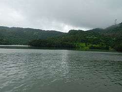
- Valvan Dam
Valvan Dam has a garden at its foot, and is a popular evening spot 2 km from the town. The dam supplies water to the Khopoli power station at the foothills of the Sahyadris for generating electricity. The Kundali River feeds into the dam's reservoir.
- Lonavla Lake
Lonavla Lake is surrounded by natural scenery, about 1.6 km from the town. The lake dries up during the winter months.
- Duke's Nose
Duke's Nose stands 12 km from Lonavla, clearly visible from the highway while driving towards Mumbai. This landmark in Khandala is popular with hikers. Also known locally as Naagphani (Cobra's Hood), the cliff owes its name to the Duke of Wellington, whose ample nose it resembles.
- Tiger's Leap

Tiger's Leap also known as Tiger's Point is a cliff-top with a sheer drop of over 650 m, giving an extensive view. Buses are available up to INS Shivaji and the remaining distance of about 1.6 km has to be covered on foot.
Just around tiger's leap, there is a small waterfall active only during the monsoon. It serves the purpose of relaxing in the water better than Bushy dam, as the force of the fall is higher. Also, after the brief steep descent, the fall becomes a stream with a fair amount of force to go all the way down to the base of the Tiger's Leap. Adventurers can trek down the stream whilst intermittently stepping back on land where the water current is too strong and the fall is steep.
- Karla Caves
Karla caves, located near Lonavla, is a complex of cave shrines built by Buddhist monks around 3rd to 2nd century B.C. A famous temple of Goddess Ekvira Devi is also present here.[10]
- Lohagad Fort
A robust climb of about 11.2 km from Malavali Railway Station takes you to the 'Iron Fort', once a formidable battle-station of Shivaji. The fort commands a view of the surrounding hills and hamlets.

A waterfall near the dam is a popular spot between Lonavla and I.N.S. Shivaji. Buses running on the I.N.S. Shivaji Road stop here.[11]
- Lion Point
Scenic point midway between Bhushi Dam and Aamby Valley .
- Tungarli Lake and Dam
This lake and Dam come to life during the Monsoon season, where youth climb the mountain top to the Dam. This dam was built during the British era and features a serene surrounding.
- Shooting Point
Another scenic point in the town of Khandala (Bazaar peth), which provides magnificent view of the Rajmachi Fort and the valley. Also the home for the St. Mary's villa.
Education
Some major educational institutes in Lonavla are:
- Institute For Future Education Entrepreneurship And Leadership
- The Cathedral Vidya School, Lonavla
- http://www.gurukullonavla.com Gurukul High School (boarding school)
- Adv.Bapusaheb.Bhonde.High.School, Lonavala
- Samundra Institute of Maritime Studies (SIMS)
- Kohinoor Business School-Kohinoor Global Campus
- Sinhgad Technical Education Society campus KG TO PG
- DC High School and Jr. College
- Auxilium Convent School
- Bosco School and Junior college, Lonavla
- Dr. B.N. Purandare Vidyalay High School
- V.P.S. HighSchool & D.P. Mehata Jr College
- Kaivalyadhama Health and Yoga Research Center
- Kendriya Vidyalaya, INS Shivaji, Lonavla
- Sadhana Institute, Old Khandala Road, Lonavla
- Kaivalya Vidya Niketan, Kaivalyadhama Lonavla. CBSE Board
- Ryewood International School, Lonavla [12]
- The Great Eastern Institute Of Maritime Studies, Lonavla
- Society of Saint Mary Virgin in India, Shanti Sadan School Lonavala [13]
Gallery
 A waterfall on the way to Lonavla.
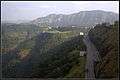 View of Western ghats, from Rajmachi
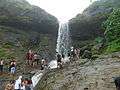 Tiger point during the rainy season
 Bhushi Dam - Lonavla
References
- ↑ http://www.mustseeindia.com/Lonavala
- ↑ "Khandala, Lonavala and Karla".
- ↑ "Lonavla, History of Maharashtra". Hotels in Lonavla. Archived from the original on April 27, 2009. Retrieved 2010-01-31.
- ↑ "Upper Deck resort- Lonavla History". Upper Deck resorts. Retrieved 2010-01-31.
- ↑ "Lonavla, India". Mumbai.org.uk. Retrieved 2010-01-31.
- ↑ Govt. of India. "Census 2001 Towns in Maharashtra" (PDF). Census of India. Census of India. Retrieved 5 December 2011.
- ↑ "Tungi fort". NIC Raigad-Alibaug.
- ↑ "Lonavla and Khandala". Maharashtra Tourism. Retrieved 2010-01-31.
- ↑ http://timesofindia.indiatimes.com/city/mumbai/First-seaplane-service-from-Mumbai-takes-off-for-Lonavala/articleshow/40868277.cms/
- ↑ "Ekveera Aai Tu Dongaravari Najar Hai Tuji Kolyavari".
- ↑ http://www.amazingmaharashtra.com/2012/09/bhushi-dam-lonavala.html
- ↑ http://www.alyshtrust.org/RIS_Info.aspx/
- ↑ http://www.csmvonline.org.uk/overseas.htm/
External links
| Wikimedia Commons has media related to Lonavla. |
| Wikisource has the text of the 1911 Encyclopædia Britannica article Lonauli. |
 Lonavla travel guide from Wikivoyage
- Kaivalyadhama yoga ashram
- The Sadhana Institute
- More info on Ekvira Devi Temple.
- Best Places to visit in Lonavala
Pune district topics | ||||||||||||||||||||||||||||||||
|---|---|---|---|---|---|---|---|---|---|---|---|---|---|---|---|---|---|---|---|---|---|---|---|---|---|---|---|---|---|---|---|---|
| History |
| |||||||||||||||||||||||||||||||
| Geography |
| |||||||||||||||||||||||||||||||
| Cities and towns |
| |||||||||||||||||||||||||||||||
| Transport | ||||||||||||||||||||||||||||||||
| Culture | ||||||||||||||||||||||||||||||||
| Education | ||||||||||||||||||||||||||||||||
| Constituencies | ||||||||||||||||||||||||||||||||