MacGillivray, South Australia
| MacGillivray South Australia | |||||||||||||
|---|---|---|---|---|---|---|---|---|---|---|---|---|---|
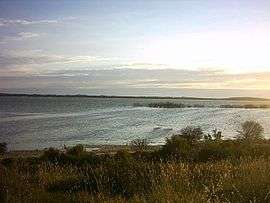 Murray Lagoon | |||||||||||||
 MacGillivray | |||||||||||||
| Coordinates | 35°48′38″S 137°31′12″E / 35.81053°S 137.519980°ECoordinates: 35°48′38″S 137°31′12″E / 35.81053°S 137.519980°E | ||||||||||||
| Population | 560 (shared with other localities in the “State Suburb of Nepean Bay”) (2011 census)[1][lower-alpha 1] | ||||||||||||
| Established | 2002[2] | ||||||||||||
| Postcode(s) | 5223[3] | ||||||||||||
| Time zone | ACST (UTC+9:30) | ||||||||||||
| • Summer (DST) | ACST (UTC+10:30) | ||||||||||||
| Location | |||||||||||||
| LGA(s) | Kangaroo Island Council[2] | ||||||||||||
| Region | Fleurieu and Kangaroo Island[4] | ||||||||||||
| County | County of Carnarvon[2] | ||||||||||||
| State electorate(s) | Finniss[5] | ||||||||||||
| Federal Division(s) | Mayo[6] | ||||||||||||
| |||||||||||||
| |||||||||||||
| Footnotes |
Coordinates[2] Locations[3] Climate[7] Adjoining localities[2] | ||||||||||||
MacGillivray is a locality in the Australian state of South Australia located on the south coast of Kangaroo Island overlooking the body of water known in Australia as the Southern Ocean and by international authorities as the Great Australian Bight.[8][9] It is located about 140 kilometres (87 mi) southwest of the state capital of Adelaide and about 24 kilometres (15 mi) south of the municipal seat of Kingscote.[2][3]
Its boundaries were created in May 2002 for the “long established name” which is derived from the cadastral unit of the Hundred of MacGillivray in which it is located.[2]
The land use within the locality consists of agriculture and conservation with the former use occupying the northern end of the locality while the latter use occupying the southern end and consisting of the following protected areas - the part of the Cape Gantheaume Conservation Park associated the wetland system at Murray Lagoon and the Cape Gantheaume Wilderness Protection Area which covers the entire coastland including the headland known as Cape Gantheaume.[10]
The locality includes the former Faulding's Eucalyptus Plantation, which is listed on the South Australian Heritage Register[11]
MacGillivray is located within the federal division of Mayo, the state electoral district of Finniss and the local government area of the Kangaroo Island Council.[2][5][6]
See also
References
- Notes
- ↑ For the 2011 census, the ‘State Suburb of Nepean Bay’ consisted of the localities of Ballast Head, Birchmore, D’Estrees Bay, Haines, Kohinoor, MacGillivray, Muston, Nepean Bay, Seal Bay and Seddon.
- Citations
- ↑ Australian Bureau of Statistics (31 October 2012). "Nepean Bay". 2011 Census QuickStats. Retrieved 21 April 2016.
- 1 2 3 4 5 6 7 8 "Search result for "MacGillivray (Locality Bounded)" (Record no SA0041846) with the following layers selected - "Suburbs and Localities" and "Place names (gazetteer)"". Property Location Browser. Government of South Australia. Retrieved 1 June 2016.
- 1 2 3 "Postcode for MacGillivray, South Australia". postcodes-australia.com. Retrieved 2 June 2016.
- ↑ "Limestone Coast SA Government regionGovernment region" (PDF). The Government of South Australia. Retrieved 9 September 2016.
- 1 2 "District of Finniss Background Profile". Electoral Commission SA. Retrieved 2 August 2015.
- 1 2 "Federal electoral division of Mayo, boundary gazetted 16 December 2011" (PDF). Australian Electoral Commission. Retrieved 2 August 2015.
- ↑ "Monthly climate statistics: Summary statistics KINGSCOTE AERO (nearest station)". Commonwealth of Australia , Bureau of Meteorology. Retrieved 1 June 2016.
- ↑ "Limits of Oceans and Seas, 3rd edition" (PDF) (PDF). International Hydrographic Organization. 1953. pp. 35–36. Retrieved 18 April 2016.
- ↑ "AHS – AA609582" (PDF) (PDF). The Australian Hydrographic Service. 5 July 2012. Retrieved 30 May 2013.
- ↑ "Development Plan, Kangaroo Island Council, Consolidated – 20 February 2014" (PDF). Department of Planning, Transport and Infrastructure. pp. 135, 152, 239, 267–271 and 324–329. Retrieved 8 March 2016.
- ↑ "Former Faulding's Eucalyptus Plantation". South Australian Heritage Register. Department of Environment, Water and Natural Resources. Retrieved 2 June 2016.