Mahbubnagar district
| Mahabubnagar district మహబూబ్ నగర్ జిల్లా محبوب نگر ضلع | |
|---|---|
| District of Telangana | |
| Country | India |
| State | Telangana |
| Tehsils | 21 |
| Government | |
| • District collector | Ronald Rose |
| Area | |
| • Total | 4,185.97 km2 (1,616.21 sq mi) |
| Population (2011) | |
| • Total | 708,952 |
| • Density | 170/km2 (440/sq mi) |
| Vehicle registration | TS–6[1] |
| Website | Official website |

Mahbubnagar district (formerly Palamoor district) is a district in the Indian state of Telangana. Mahbubnagar is the district headquarters of the district.[2]
Etymology
Mahbubnagar was formerly known as "Rukmammapet", "Palamoor".[3] The name was changed to Mahbubnagar on 4 December 1890, in honour of Mir Mahbub Ali Khan Asaf Jah VI, the Nizam of Hyderabad (1869–1911 AD). During the Nizam era, the people of this area used to sell milk, so it was named as "Palamoor".
History
The area that forms current Mahbubnagar district has held historic significance. The region was at the core of the Satavahana dynasty from 221 BC to 218 AD, and also a large part of the Chalukya dynasty from the 5th to the 11th century AD. The region was later part of the Kingdom of Golkonda (c. 1364 – 1512 AD), with its capital city Golkonda located near Hyderabad.
In 1518 it came under control of the Qutb Shahi dynasty, which reigned until 1687. The region was then a part of Hyderabad State, ruled by the Asaf Jahi dynasty, from 1724 to 1948. Mahbubnagar was most likely an historically Buddhist area, as many historic temples were destroyed by the Asaf Jahi rulers. There are no Buddhist temples remaining, however.
Mahbubnagar district became independent along with Hyderabad and joined the democratic state of India on 18 September 1948.
Geography
Mahabubnagar district is spread over an area of 4,037.00 square kilometres (1,558.69 sq mi).[4]
Demographics
As of 2011 Census of India, the district has a population of 1,318,110.[4] The official language of the district is Telugu and the second official language is Urdu.
Economy
In 2006 the Indian government named Mahbubnagar one of the country's 250 most backward districts (out of 640 total).[5] It is one of the 9 districts in Telangana currently receiving funds from the Backward Regions Grant Fund Programme (BRGF).[5]


Administrative divisions
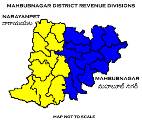
The district has two revenue divisions of Mahabubnagar and Narayanpet. These are sub-divided into 21 mandals.[4] Ronald Rose is the present collector of the district.[6]
Notable personalities
- Gona Budda Reddy - King of Vardamanapuram (now Vaddemanu, in Bijinapally mandal) and also a poet
- Burgula Ramakrishna Rao – former Chief Minister of Hyderabad State
- Suravaram Pratapareddy – social historian
- Dr.Kapilavai Lingamurthy, Telugu Poet, Nagarkurnool.
- Bulemoni Venkateshwarlu – writer and journalist
- D. Vittal Rao – politician
- S. Jaipal Reddy – politician
- Goreti Venkanna – singer
- Raja Bahadur Venkatarama Reddy - kotwal
Education
Mahbubnagar district falls under the jurisdiction of Osmania University and Palamuru University.[7] The district has many government and private junior, undergraduate and graduate colleges.
See also
- List of districts in Telangana
- Peddakarpamula &ndash village in Mahbubnagar district.
References
- ↑ http://www.sakshipost.com/telangana/2016/10/13/vehicle-registration-codes-for-new-districts-in-telangana
- ↑ "Official website of Mahabubnagar district". National Informatics center. Retrieved 14 August 2015.
- ↑ "Mahabubnagar-NIC". mahabubnagar.nic.in.
- 1 2 3 "New districts". Andhra Jyothy.com. 8 October 2016. Retrieved 8 October 2016.
- 1 2 Ministry of Panchayati Raj (8 September 2009). "A Note on the Backward Regions Grant Fund Programme" (PDF). National Institute of Rural Development. Retrieved 27 September 2011.
- ↑ "K Chandrasekhar Rao appoints collectors for new districts". Deccan Chronicle. 11 October 2016. Retrieved 13 October 2016.
- ↑ "Palamuru University". palamuruuniversity.ac.in.
External links
| Wikimedia Commons has media related to Mahbubnagar district. |
 |
Gulbarga district, Karnataka | Ranga Reddy district | Nalgonda district |  |
| Yadgir district, Karnataka | |
Guntur district, Andhra Pradesh | ||
| ||||
| | ||||
| Raichur district, Karnataka | Kurnool district, Andhra Pradesh | Prakasam district, Andhra Pradesh |