Marlboro Township, Stark County, Ohio
| Marlboro Township, Stark County, Ohio | |
|---|---|
| Township | |
|
New Baltimore Inn | |
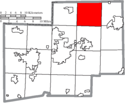 Location of Marlboro Township in Stark County | |
| Coordinates: 40°56′44″N 81°14′30″W / 40.94556°N 81.24167°WCoordinates: 40°56′44″N 81°14′30″W / 40.94556°N 81.24167°W | |
| Country | United States |
| State | Ohio |
| County | Stark |
| Area | |
| • Total | 36.5 sq mi (94.4 km2) |
| • Land | 35.8 sq mi (92.8 km2) |
| • Water | 0.6 sq mi (1.6 km2) |
| Elevation[1] | 1,217 ft (371 m) |
| Population (2000) | |
| • Total | 4,227 |
| • Density | 118.0/sq mi (45.5/km2) |
| Time zone | Eastern (EST) (UTC-5) |
| • Summer (DST) | EDT (UTC-4) |
| FIPS code | 39-47936[2] |
| GNIS feature ID | 1086981[1] |
.JPG)
Marlboro Township is one of the seventeen townships of Stark County, Ohio, United States. The 2000 census found 4,227 people in the township.[3]
Geography
Located in the northern part of the county, it borders the following townships:
- Randolph Township, Portage County - north
- Atwater Township, Portage County - northeast
- Lexington Township - east
- Washington Township - southeast
- Nimishillen Township - south
- Plain Township - southwest corner
- Lake Township - west
No municipalities are located in Marlboro Township, although the unincorporated community of Marlboro is located in the township's east.
Name and history
Statewide, the only other Marlboro Township is located in Delaware County.
Marlboro Township was historically also spelled Marlborough. In 1833, Marlborough Township contained three stores, one tannery, and four saw mills.[4]
References
- 1 2 "US Board on Geographic Names". United States Geological Survey. 2007-10-25. Retrieved 2008-01-31.
- ↑ "American FactFinder". United States Census Bureau. Retrieved 2008-01-31.
- ↑ Stark County, Ohio — Population by Places Estimates Ohio State University, 2007. Accessed 15 May 2007.
- ↑ Kilbourn, John (1833). "The Ohio Gazetteer, or, a Topographical Dictionary". Scott and Wright. p. 299. Retrieved 12 December 2013.
External links
Municipalities and communities of Stark County, Ohio, United States | ||
|---|---|---|
| Cities | 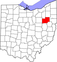 | |
| Villages | ||
| Townships | ||
| CDPs | ||
| Unincorporated communities | ||
| Footnotes | ‡This populated place also has portions in an adjacent county or counties | |
This article is issued from Wikipedia - version of the 11/12/2016. The text is available under the Creative Commons Attribution/Share Alike but additional terms may apply for the media files.