Lexington Township, Stark County, Ohio
| Lexington Township, Stark County, Ohio | |
|---|---|
| Township | |
|
Science Hill School | |
 Location of Lexington Township in Stark County | |
| Coordinates: 40°56′57″N 81°7′45″W / 40.94917°N 81.12917°WCoordinates: 40°56′57″N 81°7′45″W / 40.94917°N 81.12917°W | |
| Country | United States |
| State | Ohio |
| County | Stark |
| Area | |
| • Total | 24.7 sq mi (64.0 km2) |
| • Land | 23.0 sq mi (59.6 km2) |
| • Water | 1.7 sq mi (4.3 km2) |
| Elevation[1] | 1,060 ft (323 m) |
| Population (2000) | |
| • Total | 5,583 |
| • Density | 242.5/sq mi (93.6/km2) |
| Time zone | Eastern (EST) (UTC-5) |
| • Summer (DST) | EDT (UTC-4) |
| FIPS code | 39-43022[2] |
| GNIS feature ID | 1086979[1] |
.JPG)
Lexington Township is one of the seventeen townships of Stark County, Ohio, United States. The 2000 census found 5,583 people in the township, 5,390 of whom lived in the unincorporated portions of the township.[3]
Geography
Located in the northeastern corner of the county, it borders the following townships and city:
- Atwater Township, Portage County - north
- Deerfield Township, Portage County - northeast
- Smith Township, Mahoning County - east
- Alliance - southeast
- Washington Township - south
- Marlboro Township - west
It is the only township in the county with a border on Mahoning County.
Two municipalities are located in Lexington Township: most of the city of Alliance, in the southeast, and the village of Limaville, in the north.
Name and history
It is the only Lexington Township statewide.[4]
In 1833, Lexington Township contained three gristmills, seven saw mills, one tannery, and four stores.[5]
Government
| Historical population | |||
|---|---|---|---|
| Census | Pop. | %± | |
| 1820 | 539 | — | |
| 1830 | 869 | 61.2% | |
| 1840 | 1,640 | 88.7% | |
| 1850 | 1,996 | 21.7% | |
| 1860 | 3,102 | 55.4% | |
| 1870 | 5,700 | 83.8% | |
| 1880 | 6,287 | 10.3% | |
| 1890 | 8,994 | 43.1% | |
| 1900 | 10,325 | 14.8% | |
| 1910 | 16,700 | 61.7% | |
| 1920 | 22,241 | 33.2% | |
| 1930 | 23,712 | 6.6% | |
| 1940 | 23,292 | −1.8% | |
| 1950 | 27,578 | 18.4% | |
| 1960 | 29,074 | 5.4% | |
| 1970 | 5,975 | −79.4% | |
| 1990 | 5,291 | — | |
| 2000 | 5,583 | 5.5% | |
| [6] | |||
The township is governed by a three-member board of trustees, who are elected in November of odd-numbered years to a four-year term beginning on the following January 1. Two are elected in the year after the presidential election and one is elected in the year before it. There is also an elected township fiscal officer,[7] who serves a four-year term beginning on April 1 of the year after the election, which is held in November of the year before the presidential election. Vacancies in the fiscal officership or on the board of trustees are filled by the remaining trustees.
References
- 1 2 "US Board on Geographic Names". United States Geological Survey. 2007-10-25. Retrieved 2008-01-31.
- ↑ "American FactFinder". United States Census Bureau. Archived from the original on September 11, 2013. Retrieved 2008-01-31.
- ↑ Stark County, Ohio — Population by Places Estimates Ohio State University, 2007. Accessed 15 May 2007.
- ↑ "Detailed map of Ohio" (PDF). United States Census Bureau. 2000. Retrieved 2007-02-16.
- ↑ Kilbourn, John (1833). "The Ohio Gazetteer, or, a Topographical Dictionary". Scott and Wright. p. 271. Retrieved 12 December 2013.
- ↑ census data: 1820 : 1820 page 137 , 1830 : Kilbourn, John (1831). The Ohio gazetteer: or, Topographical dictionary: describing the several ... in the State of Ohio. self. p. 332. , 1840, 1880 : Howe, Henry (1907). Historical Collections of Ohio, The Ohio Centennial Edition. The State of Ohio. p. 285. , 1850, 1860, 1870 : 1870 page 35 , 1890, 1900 : Hunt, William C. (1901). Population of the United States by states and territories, counties, and minor Civil Divisions, as returned at the Twelfth Census: 1900. United States Census Printing Office. p. 318. , 1910, 1920, 1930 : 1930 page 56 , 1940, 1950 : 1950 page 21 , 1960, 1970 : 1970 page 135 , 1990 : 1990 , 2000 : 2000 (includes Alliance before 1970)
- ↑ §503.24, §505.01, and §507.01 of the Ohio Revised Code. Accessed 4/30/2009.
External links
Municipalities and communities of Stark County, Ohio, United States | ||
|---|---|---|
| Cities | 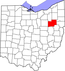 | |
| Villages | ||
| Townships | ||
| CDPs | ||
| Unincorporated communities | ||
| Footnotes | ‡This populated place also has portions in an adjacent county or counties | |