Louisville, Ohio
| Louisville, Ohio | |
|---|---|
| City | |
|
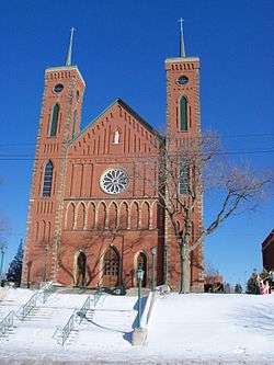
St. Louis Church, built 1870 | |
| Nickname(s): "The Constitution Town" | |
 Location of Louisville, Ohio | |
 Location of Louisville in Stark County | |
| Coordinates: 40°50′14″N 81°15′33″W / 40.83722°N 81.25917°WCoordinates: 40°50′14″N 81°15′33″W / 40.83722°N 81.25917°W | |
| Country | United States |
| State | Ohio |
| County | Stark |
| Government | |
| • Mayor | Patricia A. ("Pat") Fallot |
| Area[1] | |
| • Total | 5.49 sq mi (14.22 km2) |
| • Land | 5.49 sq mi (14.22 km2) |
| • Water | 0 sq mi (0 km2) |
| Elevation[2] | 1,142 ft (348 m) |
| Population (2010)[3] | |
| • Total | 9,186 |
| • Estimate (2012[4]) | 9,152 |
| • Density | 1,673.2/sq mi (646.0/km2) |
| Time zone | Eastern (EST) (UTC−5) |
| • Summer (DST) | EDT (UTC−4) |
| ZIP code | 44641 |
| Area code | 330 |
| FIPS code | 39-45094[5] |
| GNIS feature ID | 1061447[2] |
Louisville (pronounced LEWIS-ville) is a city in Stark County in the U.S. state of Ohio. The population was 9,186 at the 2010 census. It is part of the Canton-Massillon, OH Metropolitan Statistical Area.
History
On October 8, 1834, Louisville was formally settled by Henry Lautzenheiser, from Germany, and Henry Fainot, a French Huguenot. The city was named after Lautzenheiser's son, Lewis, and called Lewisville, Ohio. The name of the town was also considered appropriate because of the fact that it was initially surveyed by the similar-sounding name of Lewis Vail. When the post office was established in 1837, with Sam Petree as its first postmaster, it was discovered Ohio already had a Lewisville, so the spelling was changed to Louisville.[6][7]
Within Louisville's early days, the town competed with the fellow Nimishillen Township community of Harrisburg for growth. Harrisburg initially flourished due to its accessibility as a stagecoach stop between Canton, Alliance, Cleveland, and Pittsburgh. Meanwhile, Louisville also grew, due to its location upon the east branch of the Nimishillen Creek, which flows toward Canton. However, when the Pittsburgh, Fort Wayne and Chicago Railway was laid through Louisville in 1852, Louisville began to grow more quickly than Harrisburg, which struggled with the difficulty of hauling its main product, wheat, by barge.[8] Today, Harrisburg is now an unincorporated community, marked only by a handful of businesses and a Roman Catholic parish.[9]
On April 1, 1872, Louisville was officially incorporated as a village, with George Violand elected as Louisville's first mayor. By the late 19th Century, Louisville contained many quickly growing businesses, including: a plow manufacturing company, a wooden mill, a brewery, a basket factory, flour mills, tanneries, a brick yard, two hotels, a shoe factory, and a number of taverns/saloons (Louisville had twenty saloons at one point, giving the town a rather notorious reputation). Three of these businesses, Star Mill, Town Tavern, and the Mainstay Bed & Breakfast, remain open to this day. Furthermore, many of the buildings constructed within Louisville during this time period are listed upon the National Register of Historic Places. Such locations include Saint Louis Catholic Church, which was completed in 1870 and dedicated in 1878, and the city's historic downtown district, roughly bordered by Chapel Street, Lincoln Court, St. Louis Court, Nickelplate Street, East Gorgas Street, and Center Court.[10] The city's current weekly newspaper, The Louisville Herald, was first published in 1887. For a brief time, the town also had a Roman Catholic college, established by the Reverend Louis Hoffer, located across the street from St. Louis Church. Called Saint Louis College, it opened in 1866 under the operation of the Diocese of Cleveland. The Congregation of St. Basil of Toronto assumed control of the college the following year, and Saint Louis College closed in 1873, due to lack of funds and transportation difficulties for the students. After briefly serving as an all-girls academy and a school for deaf mutes, The building became an orphanage under the guidance of the Vincentian Sisters of Charity. The Saint Louis Orphan Asylum closed in 1925, and became a hospice for the elderly, named St. Joseph's, in 1927. The old red brick building was razed in 1975, as St. Joseph's moved across the street from St. Thomas Aquinas High School. A McDonald's is now located upon the site.[8][11]
The early 1880s saw the arrival of telephone toll lines to Louisville. Louisville's first public street lights, twelve oil burners, were lit downtown for Christmas 1884. In 1894, a public water system was established for Louisville, and a sewage system installation followed in 1910. The town's Main Street became Louisville's first fully paved road in 1914. In 1960, Louisville's residents voted for the village to become a city.[8][11]
Louisville is also known as the "Constitution Town". This is due to the fact that a resident of Louisville, Olga T. Weber, petitioned for the establishment of Constitution Day for the United States in 1952. Her lobbying led to the Ohio General Assembly proclaiming September 17. as a statewide "Constitution Day", under a law signed by then-governor Frank J. Lausche. The following year, Weber urged the United States Senate to declare the week of September 17–23 as "Constitution Week". Her request was approved by both the Senate and the United States House of Representatives, and signed into law by President Dwight D. Eisenhower. On April 15, 1957, Louisville's City Council officially declared itself "The Constitution Town".[8] The city continues to hold a "Constitution Week" celebration annually during the week of September 17.
Geography
Louisville is located at 40°50′14″N 81°15′33″W / 40.83722°N 81.25917°W (40.837258, -81.259178).[12] The east branch of Nimishillen Creek flows through the city.[13]
According to the United States Census Bureau, the city has a total area of 5.49 square miles (14.22 km2), all land.[1]
Demographics
| Historical population | |||
|---|---|---|---|
| Census | Pop. | %± | |
| 1880 | 1,650 | — | |
| 1890 | 1,323 | −19.8% | |
| 1900 | 1,374 | 3.9% | |
| 1910 | 1,678 | 22.1% | |
| 1920 | 2,008 | 19.7% | |
| 1930 | 3,130 | 55.9% | |
| 1940 | 3,379 | 8.0% | |
| 1950 | 3,801 | 12.5% | |
| 1960 | 5,116 | 34.6% | |
| 1970 | 6,298 | 23.1% | |
| 1980 | 7,996 | 27.0% | |
| 1990 | 8,087 | 1.1% | |
| 2000 | 8,904 | 10.1% | |
| 2010 | 9,186 | 3.2% | |
| Est. 2015 | 9,126 | [14] | −0.7% |
| Sources:[5][15][16][17][18][19][20] | |||
2010 census
As of the census[3] of 2010, there were 9,186 people, 3,727 households, and 2,498 families residing in the city. The population density was 1,673.2 inhabitants per square mile (646.0/km2). There were 3,995 housing units at an average density of 727.7 per square mile (281.0/km2). The racial makeup of the city was 98.3% White, 0.2% African American, 0.2% Native American, 0.3% Asian, 0.2% from other races, and 0.9% from two or more races. Hispanic or Latino of any race were 1.3% of the population.
There were 3,727 households of which 33.9% had children under the age of 18 living with them, 49.4% were married couples living together, 13.3% had a female householder with no husband present, 4.4% had a male householder with no wife present, and 33.0% were non-families. 28.0% of all households were made up of individuals and 15.4% had someone living alone who was 65 years of age or older. The average household size was 2.44 and the average family size was 2.99.
The median age in the city was 39.4 years. 25.4% of residents were under the age of 18; 7.4% were between the ages of 18 and 24; 24.7% were from 25 to 44; 24.5% were from 45 to 64; and 18% were 65 years of age or older. The gender makeup of the city was 46.5% male and 53.5% female.
2000 census
As of the census[5] of 2000, there were 8,904 people, 3,444 households, and 2,465 families residing in the city. The population density was 1,726.6 people per square mile (666.3/km²). There were 3,544 housing units at an average density of 687.2 per square mile (265.2/km²). The racial makeup of the city was 98.53% White, 0.31% African American, 0.15% Native American, 0.29% Asian, 0.07% from other races, and 0.65% from two or more races. Hispanic or Latino of any race were 0.83% of the population.
There were 3,444 households out of which 35.5% had children under the age of 18 living with them, 56.6% were married couples living together, 11.5% had a female householder with no husband present, and 28.4% were non-families. 24.2% of all households were made up of individuals and 10.6% had someone living alone who was 65 years of age or older. The average household size was 2.54 and the average family size was 3.03.
In the city the age distribution of the population shows 27.1% under the age of 18, 7.5% from 18 to 24, 29.7% from 25 to 44, 20.6% from 45 to 64, and 15.2% who were 65 years of age or older. The median age was 36 years. For every 100 females there were 88.7 males. For every 100 females age 18 and over, there were 84.7 males.
The median income for a household in the city was $41,490, and the median income for a family was $49,844. Males had a median income of $37,625 versus $22,398 for females. The per capita income for the city was $20,783. About 3.1% of families and 4.0% of the population were below the poverty line, including 4.5% of those under age 18 and 6.9% of those age 65 or over.
Education
Public schools
Louisville, as well as the majority of the surrounding Nimishillen Township, is served by the Louisville City School District, composed of Louisville High School, Louisville Middle School, Louisville Elementary School and North Nimishillen Elementary School.
Private schools
St. Thomas Aquinas High School/Middle School and the Holy Cross Academy at Saint Louis Campus are located within the city of Louisville. Saint Louis School opened its doors in 1924. It served Grades Kindergarten through Eighth until the 2013–2014 school year, and now enrolls students for Grades PreK-5th.[21] St. Thomas Aquinas High School opened in 1964. In 2014, it added a Middle School program to serve Grades 6-8.
Notable people
- Augustus D. Juilliard, philanthropist. A Juilliard Arts Center established in his honor is located within Louisville.
- Edward Julien Moinet, United States Federal Court judge
- Joseph Gabriel Harner, US Navy, Medal of Honor at United States occupation of Veracruz in 1914
- Shirley Givens, Juilliard-trained violinist. Appeared on the Ed Sullivan Show with the Zing Merlin Troupe, was a winner upon the Dennis James and John Reed King talent show Chance of a Lifetime, made a week-long appearance on Arthur Godfrey and His Friends, and performed with James Molton for President Dwight D. Eisenhower.[8][11]
- Pat Rebillot, jazz pianist.[8][11]
- Don Atkinson, Broadway actor. Appeared in twenty Broadway plays, including Sail Away, Mr. President, which he also performed in front of Presidents Eisenhower and John F. Kennedy. He directed and produced his own off-Broadway show, The Red Robin Review, than ran for one summer. Atkinson later became an actor upon several soap operas, including The Doctors and Love of Life. He also appeared upon numerous national commercial spots, including for Dannon.[8][11]
- Bob Gladieux, former NFL running back for the Boston/New England Patriots and Buffalo Bills from 1969 to 1972. Gladieux also played for the Winnipeg Jets of the CFL in 1973, and New York Stars/Charlotte Hornets of the former World Football League from 1974 to 1975. Prior to his NFL career, Gladieux was a three-year letterman for the Notre Dame Fighting Irish football team from 1966 to 1968, including the 1966 National Championship team. That year, Gladieux scored the Irish' only touchdown in the "Game of the Century" versus Michigan State. He also was named an honorable mention Parade All-American as a senior. Gladieux was charter member of the Stark County High School Football Hall of Fame, which was established in 2002. His 3,469 rushing yards at Louisville High School remain the tenth-most by any Stark County high school football player[22][23][24][25]
- Mark Stier, three-year starting linebacker for the Ohio State Buckeyes football team from 1966–1968, including for the 1968 National Championship team. Stier was a Buckeyes captain in 1968, and earned the honor of being the team MVP, as well as being named an Academic All-American and Academic All-Big Ten (a distinction he also earned in 1966). He was inducted into the Stark County High School Football Hall of Fame in 2009.[26]
- Ken Kuhn, four-year letter-winning linebacker for the Ohio State Buckeyes football team from 1972 to 1975. Kuhn was also named to the Scholastic All-Big Ten team during his junior and senior seasons, and was a Buckeyes senior captain. He was drafted by the Cincinnati Bengals in the seventh round in 1976, but retired in 1977 without ever playing in an NFL regular season game due to knee and shoulder injuries. Kuhn was a 2006 inductee of the Stark County High School Football Hall of Fame.[27][28]
- Kyle Smith, former Minor League Baseball right-handed pitcher from 2009 to 2010. Smith was a three-year letter-winner for the Kent State Golden Flashes baseball team from 2006 to 2008, as the Flashes won Mid-American Conference league titles during each of those three years. He also won All-MAC Tournament Team honors in 2007, and All-MAC and All-Midwest Region accolades in 2008. The Cleveland Indians drafted him in the 20th Round in 2009, and he played for the Tribe's Short season class "A"-affiliate, the Mahoning Valley Scrappers, from 2009 to 2010.[29] After retiring in 2010 due to an arm injury, Smith returned to Kent State, and became the Golden Flashes' assistant pitching coach. In 2012, he helped Kent State reach the College World Series. In 2013, Smith was the pitching coach for the Malone University Pioneers.[30] He was then the pitching coach for his alma mater's rival, the University of Akron Zips, from 2014 to July 2015, when the university dropped its baseball program.[31]
References
- 1 2 "US Gazetteer files 2010". United States Census Bureau. Retrieved 2013-01-06.
- 1 2 "US Board on Geographic Names". United States Geological Survey. 2007-10-25. Retrieved 2008-01-31.
- 1 2 "American FactFinder". United States Census Bureau. Retrieved 2013-01-06.
- ↑ "Population Estimates". United States Census Bureau. Retrieved 2013-06-17.
- 1 2 3 "American FactFinder". United States Census Bureau. Retrieved 2008-01-31.
- ↑ Goodman, Rebecca (2005). This Day in Ohio History. Emmis Books. p. 121. Retrieved 21 November 2013.
- ↑ Smith, Kenneth R. Louisville – The Way It Was 1834–1990. Edited by Tracy Z. Poole. Second Edition. Canton, Ohio: Claymore Publishing, 1997.
- 1 2 3 4 5 6 7 http://www.louisvilleohio.com/index.php/community/history
- ↑ http://ohio.hometownlocator.com/oh/stark/harrisburg.cfm
- ↑ National Register of Historic Places listings in Stark County, Ohio
- 1 2 3 4 5 Smith, Kenneth R. Louisville – The Way It Was 1834–1990. Edited by Tracy Z. Poole. Second Edition. Canton, Ohio: Claymore Publishing, 1997.
- ↑ "US Gazetteer files: 2010, 2000, and 1990". United States Census Bureau. 2011-02-12. Retrieved 2011-04-23.
- ↑ DeLorme (1991). Ohio Atlas & Gazetteer. Yarmouth, Maine: DeLorme. ISBN 0-89933-233-1.
- ↑ "Annual Estimates of the Resident Population for Incorporated Places: April 1, 2010 to July 1, 2015". Retrieved July 2, 2016.
- ↑ "Population of Civil Divisions Less than Counties" (PDF). Statistics of the Population of the United States at the Tenth Census. U.S. Census Bureau. Retrieved 28 November 2013.
- ↑ "Population: Ohio" (PDF). 1910 U.S. Census. U.S. Census Bureau. Retrieved 28 November 2013.
- ↑ "Population: Ohio" (PDF). 1930 US Census. U.S. Census Bureau. Retrieved 28 November 2013.
- ↑ "Number of Inhabitants: Ohio" (PDF). 18th Census of the United States. U.S. Census Bureau. Retrieved 22 November 2013.
- ↑ "Ohio: Population and Housing Unit Counts" (PDF). U.S. Census Bureau. Retrieved 22 November 2013.
- ↑ "Incorporated Places and Minor Civil Divisions Datasets: Subcounty Population Estimates: April 1, 2010 to July 1, 2012". U.S. Census Bureau. Retrieved 25 November 2013.
- ↑ http://www.slslouisville.com/
- ↑ http://louisvilleleopardfootball.com/HOF/bglad.htm
- ↑ http://www.pro-football-reference.com/players/G/GladBo00.htm
- ↑ http://cantonmckinley.com/content/daves-qjust-the-factsq/football/107-stark-county-football-records
- ↑ http://www.cantonrep.com/article/20110721/News/307219871/?Start=1
- ↑ http://www.cantonrep.com/article/20090710/News/307109864
- ↑ http://www.louisvilleleopardfootball.com/hof/kkuhn.htm
- ↑ http://www.cantonrep.com/article/20110721/News/307219871
- ↑ http://www.baseball-reference.com/minors/player.cgi?id=smith-004kyl
- ↑ http://malonepioneers.com/coaches.aspx?rc=452&path=baseball
- ↑ http://www.hustlebelt.com/akron-zips/2015/7/11/8929775/akron-cuts-baseball
External links
| Wikivoyage has a travel guide for Louisville, Ohio. |
Municipalities and communities of Stark County, Ohio, United States | ||
|---|---|---|
| Cities |  | |
| Villages | ||
| Townships | ||
| CDPs | ||
| Unincorporated communities | ||
| Footnotes | ‡This populated place also has portions in an adjacent county or counties | |