Massachusetts Route 16
| ||||
|---|---|---|---|---|
|
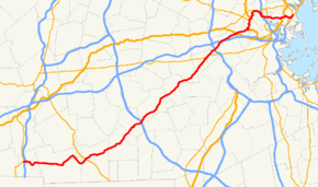
Map of the Boston area with Route 16 in red | ||||
| Route information | ||||
| Length: | 59.8646 mi[1] (96.3427 km) | |||
| Major junctions | ||||
| West end: |
| |||
| East end: |
| |||
| Location | ||||
| Counties: | Worcester, Middlesex, Norfolk, Suffolk | |||
| Highway system | ||||
| ||||

Route 16 is an east–west state highway in Massachusetts. It begins in the west at an intersection with Route 12 and Route 193 in Webster, just north of the Connecticut state border. It runs in a generally southwest-northeast routing through a number of Boston's suburbs and runs to the west and then north of the city before ending in Revere at an intersection with Route 1A and Route 60.
Much of Route 16 east of the Newton-Wellesley town line, and especially from Cambridge eastward, is a multi-lane parkway, although it is not limited access for any significant length of road. Segments of Route 16 are also known as the Mystic Valley Parkway, the Alewife Brook Parkway, and the Revere Beach Parkway, among other names.
From the western end of the Route 135 concurrency in Wellesley to Route 30 (Commonwealth Avenue) in Newton, the route serves as a part of the Boston Marathon, from the halfway point to just before Mile 18 and the hills.
Route description
Webster to Milford
Route 16 begins at Routes 12 and 193, not far from the Connecticut border. In Webster, along the shore of Lake Chaubunagungamaug,[2] it intersects I-395.
After passing I-395, the route continues to the northeast, going through Douglas (with a trip through the Douglas State Forest), the Blackstone River Valley National Heritage Corridor, Uxbridge, Mendon, Hopedale, and Milford, while passing beneath I-495 shortly thereafter.
Milford to Newton
This area west of Boston, also called MetroWest, that Route 16 now travels through contains several quintessential New England towns. The route now goes by restored antique, colonial homes and town buildings.[3]
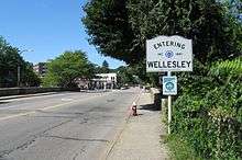
From I-495, Route 16 goes northeasterly past Holliston and the Elm Bank Reservation in Sherborn. The road then crosses into Natick while traveling next to the Dover line, and goes through Wellesley, where Wellesley College and Babson College are located. Entering Newton, the route travels past Lasell College before crossing into Middlesex County.
Newton to Revere
In Newton, Route 16 crosses Route 30 and Route 128 (Interstate 95), later crossing I-90, the Massachusetts Turnpike, in West Newton; Pike Exit 16 here provides access to and from the east only. It enters Watertown shortly before crossing the Charles River, and intersects U.S. Route 20 in Watertown Square. The route passes by Mount Auburn Cemetery before entering Cambridge. Continuing east, Route 16 joins U.S. Route 3 and Route 2, turning north to pass by Fresh Pond and the large parking garage at the MBTA Alewife Station. From there, Route 2 splits off at the eastern end of the freeway portion of the Concord Turnpike, while Routes 3 and 16 continue north on Alewife Brook Parkway. Route 3 exits west at Massachusetts Avenue, while Route 16 continues north on the parkway into Somerville, meeting up with the Mystic Valley Parkway just south of the Mystic River.
Route 16 follows the Mystic Valley Parkway generally eastward, traveling beside the Mystic River downstream and eventually crossing it into Medford. It soon is joined from the north by Massachusetts Route 38, and passes near Medford Square (after recrossing the river), where Route 38 exits to the south on Main Street. Route 16 then crosses Interstate 93 in a series of ramps that include onramps to the north and south of I-93 from Route 16's eastbound lanes, and a ramp from I-93 southbound to Route 16 east. Route 16 then crosses the Mystic River again, reaching the Wellington Circle junction with Massachusetts Route 28 in Medford. This junction marks the end of the Mystic Valley Parkway and the beginning of the Revere Beach Parkway, on which Route 16 continues eastward, passing the Wellington MBTA station and crossing the Malden River. The route continues east through Everett (where it has an interchange with Massachusetts Route 99) and Chelsea, where it has an interchange with U.S. Route 1 at the border with Revere. The stretch between Wellington Circle and Route 1 is characterized by a fairly dense mixture of residential, industrial, and commercial uses, in contrast to the more residential and park-like settings of the section between Wellington and Route 2.
Continuing eastward from Route 1, Route 16 has an interchange with Massachusetts Route 107 at Cronin Park before heading north to a junction with Winthrop Street, where the Revere Beach Parkway and Massachusetts Route 145 turn right. Route 16 goes a short way further north, before it ends near Revere Beach and the Atlantic Ocean at Timothy J. Mahoney Circle, a junction with Routes 1A and 60 in Revere.
History
Parts of Route 16 were historically maintained by the Metropolitan District Commission (MDC), and while the MDC no longer exists, the parkway portions of the route are still patrolled by the Massachusetts State Police and maintained by the Massachusetts Department of Conservation and Recreation as a remnant of the former MDC jurisdiction.[4]
Major intersections
| County | Location | mi | km | Destinations | Notes |
|---|---|---|---|---|---|
| Worcester | Webster | 0.00 | 0.00 | Western terminus; northern terminus of Route 193 | |
| 0.20 | 0.32 | Exit 2 on I-395 | |||
| Douglas | 6.91 | 11.12 | Northern terminus of Route 96 | ||
| Uxbridge | 12.20 | 19.63 | Exit 3 on Route 146 | ||
| 14.40 | 23.17 | Brief concurrency with Route 122 | |||
| Milford | 21.40 | 34.44 | |||
| 22.90 | 36.85 | Southern terminus of Route 85 | |||
| 23.30 | 37.50 | Western terminus of Route 109 | |||
| Middlesex | Holliston | 27.30 | 43.94 | Southern terminus of concurrency with Route 126 | |
| 29.60 | 47.64 | Northern terminus of concurrency with Route 126 | |||
| Sherborn | 33.00 | 53.11 | Southern terminus of concurrency with Route 27; some movements via Sawin Street | ||
| 33.30 | 53.59 | Northern terminus of concurrency with Route 27 | |||
| Norfolk | Wellesley | 39.10 | 62.93 | Western terminus of concurrency with Route 135; some movements via Weston Road | |
| 39.30 | 63.25 | Eastern terminus of concurrency with Route 135 | |||
| 40.70 | 65.50 | Partial interchange via Worcester and Grantland Roads | |||
| Middlesex | Newton | 42.20 | 67.91 | Exit 21 on I-95 / Route 128 | |
| 43.40 | 69.85 | ||||
| 44.00 | 70.81 | Eastbound exit and westbound entrance; exit 16 on I-90 | |||
| Watertown | 46.80 | 75.32 | Watertown Square | ||
| Cambridge | 49.40 | 79.50 | Southern terminus of concurrency with US 3 / Route 2 | ||
| North Cambridge | 50.70 | 81.59 | Northern terminus of concurrency with Route 2 | ||
| 51.10 | 82.24 | Northern terminus of concurrency with US 3 | |||
| Somerville | Mystic Valley Parkway west – Arlington | Route 16 joins the Mystic Valley Parkway | |||
| Medford | 53.00 | 85.30 | Brief concurrency with Route 38; to Route 60 | ||
| 53.50 | 86.10 | Southbound exit (to eastbound only); north and southbound entrances from eastbound only; exit 31 on I-93 | |||
| 55.30 | 89.00 | Mystic Valley Parkway transitions to Revere Beach Parkway | |||
| Everett | 56.10 | 90.28 | Dual rotary intersection | ||
| Suffolk | Revere | 58.50 | 94.15 | Interchange with the Northeast Expressway | |
| 58.80 | 94.63 | Interchange with Broadway; southern terminus of Route 107 | |||
| 59.6 | 95.9 | Northern terminus of Route 145 | |||
| 59.8646 | 96.3427 | Rotary; eastern terminus of Routes 16 and 60 | |||
1.000 mi = 1.609 km; 1.000 km = 0.621 mi
| |||||
References
| Wikimedia Commons has media related to Massachusetts Route 16. |
- ↑ "Office of Transportation Planning - 2005 Road Inventory". Executive Office of Transportation. 2005. Retrieved 2008-06-09.
- ↑ Columbia Gazetteer of North America. "Chaubunagungamaug, Lake, Massachusetts (MA), United States". AllRefer.com. Retrieved 2008-06-09.
- ↑ "Holliston Massachusetts". SmartMoves. 2004. Retrieved 2008-06-09.
- ↑ "Parkway Maintenance Matrix" (PDF). Massachusetts Department of Conservation and Recreation. Retrieved 2008-06-10.