Framingham, Massachusetts
| Framingham, Massachusetts | ||
|---|---|---|
| Town | ||
|
The Museum at the Framingham History Center | ||
| ||
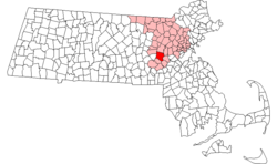 Location in Middlesex County in Massachusetts | ||
| Coordinates: 42°16′45″N 71°25′00″W / 42.27917°N 71.41667°WCoordinates: 42°16′45″N 71°25′00″W / 42.27917°N 71.41667°W | ||
| Country | United States | |
| State | Massachusetts | |
| County | Middlesex | |
| Settled | 1650 | |
| Incorporated | 1700 | |
| Government | ||
| • Type | Representative town meeting | |
| Area | ||
| • Total | 26.4 sq mi (68.5 km2) | |
| • Land | 25.1 sq mi (65.1 km2) | |
| • Water | 1.3 sq mi (3.4 km2) | |
| Elevation | 165 ft (50 m) | |
| Population (2010) | ||
| • Total | 68,318 | |
| • Density | 2,581.1/sq mi (995.2/km2) | |
| Time zone | Eastern (UTC−5) | |
| • Summer (DST) | Eastern (UTC−4) | |
| ZIP code | 01701, 01702, 01703, 01704, 01705 | |
| Area code(s) | 508 / 774 | |
| FIPS code | 25-24925 | |
| GNIS feature ID | 0618224 | |
| Website | www.framinghamma.gov/ | |

Framingham (IPA: /ˈfreɪmɪŋˌhæm/) is a town in Middlesex County, Massachusetts, United States. The population was 68,318 as of the United States 2010 Census,[1] making it the 14th most populous municipality in Massachusetts.[2] Founded in 1700, Framingham was placed at # 36 on 'Best Places to Live in US' by CNN Money magazine in 2012.[3][4]
History
Framingham, sited on the ancient trail known as the Old Connecticut Path, was first settled when John Stone settled on the west bank of the Sudbury River in 1647. In 1660, Thomas Danforth, an official of the Bay Colony, formerly of Framlingham, Suffolk, received a grant of land at "Danforth's Farms" and began to accumulate over 15,000 acres (100 km2). He strenuously resisted petitions for incorporation of the town, which was officially incorporated in 1700, following his death the previous year. Why the "L" was dropped from the new town's name is not known. The first church was organized in 1701, the first teacher was hired in 1706, and the first permanent schoolhouse in 1716.
On February 22, 1775, the British general Thomas Gage sent two officers and an enlisted man out of Boston to survey the route to Worcester, Massachusetts. In Framingham those spies stopped at Buckminster's Tavern. They watched the town militia muster outside the building, impressed with the men's numbers but not their discipline. Though "the whole company" came into the tavern after their drill, the officers managed to remain undetected and continued on their mission the next day.[5] Gage did not order a march along that route, instead ordering troops to Concord, Massachusetts, on April 18–19. Framingham sent two militia companies totaling about 130 men into the Battles of Lexington and Concord that followed; one of those men was wounded.[6]
In the years prior to the American Civil War, Framingham was an annual gathering-spot for members of the abolitionist movement. Each Independence Day from 1854 to 1865, the Massachusetts Anti-Slavery Society held a rally in a picnic area called Harmony Grove near what is now downtown Framingham. At the 1854 rally, William Lloyd Garrison burned copies of the Fugitive Slave Law of 1850, judicial decisions enforcing it, and the United States Constitution. Other prominent abolitionists present that day included William Cooper Nell, Sojourner Truth, Wendell Phillips, Lucy Stone, and Henry David Thoreau.[7]
During the post–World War II baby boom, Framingham, like many other suburban areas, experienced a large increase in population and housing. Much of the housing constructed during that time consisted of split-level and ranch-style houses.
Framingham is known for the Framingham Heart Study, as well as for the Dennison Manufacturing Company, which was founded in 1844 as a jewelry and watch box manufacturing company by Aaron Lufkin Dennison, who became the pioneer of the American System of Watch Manufacturing at the nearby Waltham Watch Company. His brother Eliphalet Whorf Dennison developed the company into a sizable industrial complex which merged in 1990 into Avery Dennison, with headquarters in Pasadena, California, and active corporate offices in the town.
In 2000, Framingham celebrated its Tercentennial.
Geography
Framingham is located at 42°17′59″N 71°25′35″W / 42.29972°N 71.42639°W (42.299795, −71.426627).[8]
According to the United States Census Bureau, the town has a total area of 26.4 square miles (68.5 km²). 25.1 square miles (65.1 km²) of it is land and 1.3 square miles (3.4 km²) of it (4.99%) is water.[8]
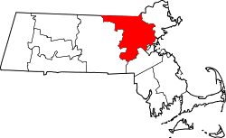
Framingham is located in eastern Massachusetts, 20 miles (32 km) west of Boston, midway between Boston and Worcester. It is bordered by Southborough and Marlborough on the west; Sherborn and Ashland on the south; Natick on the east; Wayland on the northeast; and Sudbury on the north.
The town of Framingham is divided by Route 9, which passes east-to-west through the middle of the town. South Framingham includes Downtown Framingham (the town government seat), and the villages of Coburnville, Lokerville, and Salem End Road. North Framingham includes the villages of Nobscot, Pinefield, Ridgefield, and Saxonville plus Framingham Center (the physical center of town, featuring the town commons).
Demographics
| Historical population | ||
|---|---|---|
| Year | Pop. | ±% |
| 1850 | 4,252 | — |
| 1860 | 4,227 | −0.6% |
| 1870 | 4,968 | +17.5% |
| 1880 | 6,235 | +25.5% |
| 1890 | 9,239 | +48.2% |
| 1900 | 11,302 | +22.3% |
| 1910 | 12,948 | +14.6% |
| 1920 | 17,033 | +31.5% |
| 1930 | 22,210 | +30.4% |
| 1940 | 23,214 | +4.5% |
| 1950 | 28,086 | +21.0% |
| 1960 | 44,526 | +58.5% |
| 1970 | 64,048 | +43.8% |
| 1980 | 65,113 | +1.7% |
| 1990 | 64,989 | −0.2% |
| 2000 | 66,910 | +3.0% |
| 2010 | 68,318 | +2.1% |
Source: United States Census records and Population Estimates Program data.[9][10][11][12][13][14][15][16][17][18] | ||
As of the census of 2010,[19] there were 68,318 people, 27,529 households, and 16,573 families residing in the town. The population density was 2,663.6 people per square mile (1,028.4/km²). There were 26,734 housing units at an average density of 2,728.6 per square mile (410.9/km²). The racial makeup of the town was 65.3% White, 5.8% Black, 0.8% Native American, 6.3% Asian, 0.1% Pacific Islander, 6.27% from other races, and 3.38% from two or more races. Hispanic or Latino of any race were 13.4% of the population (4.7% Puerto Rican, 1.8% Guatemalan, 1.5% Salvadoran, 1.1% Dominican, 0.9% Mexican, 0.6% Colombian, 0.3% Peruvian). (Source: 2010 Census Quickfacts)
There were 26,153 households, out of which 29.1% had children under the age of 18 living with them, 50.0% were married couples living together, 10.2% had a female householder with no husband present, and 36.6% were non-families. 28.7% of all households were made up of individuals and 9.1% had someone living alone who was 65 years of age or older. The average household size was 2.43 and the average family size was 3.02.
In the town, the age distribution of the population shows 21.4% under the age of 18, 9.0% from 18 to 24, 34.5% from 25 to 44, 22.1% from 45 to 64, and 13.0% who were 65 years of age or older. The median age was 36 years. For every 100 females there were 91.3 males. For every 100 females age 18 and over, there were 88.6 males.
The median income for a household in the town was $54,288, and the median income for a family was $67,420. Males had a median income of $46,122 versus $35,941 for females. The per capita income for the town was $27,758. About 8.0% of families and 16.0% of the population were below the poverty line, including 11.4% of those under age 18 and 6.1% of those age 65 or over.
Brazilian immigrants have a major presence in Framingham.[20][21][22][23] Since the 1980s, a large segment of the Brazilian population has come from the single city of Governador Valadares.[24]
Housing
Framingham is one of the few towns in Massachusetts that have met their legal requirement of 10% for Massachusetts Chapter 40B Affordable housing which mostly targets people with income levels in the 70% of median income. In addition to its 40B Affordable component, Framingham has a large percentage of rental units which target people in the 30% of median income bracket. Framingham has a much larger percentage of rental households than any of the surrounding towns. Statewide, the median income of rental households is 47% of the median for homeowners, and in Middlesex County it is slightly more than 50%. In Framingham, the median renter income of $33,626 is 45% of the median homeowner income of $75,040.[25]
Housing in South Framingham is mainly single-family houses on lots of less than 0.5 acres (0 ha),[26] multi-family homes or apartments. Additionally much of the town's affordable housing is located south of Route 9. However, there a large number of large, single-family homes around Salem End Road on the West Side of South Framingham. This region is often overlooked as being in South Framingham because the area is physically separated from most of the South Side due to a series of reservoirs and the Sudbury River.[27] Also, there are many large Victorian houses located along the shores of Learned and Gleason Ponds, and along Concord St. and Union Ave. near Downtown Framingham. Additionally, the West Side of South Framingham along Route 9 has several large tracts of multi-story apartment buildings that comprise a major part of the town's apartment stock.[28][29][30]
North Framingham was originally mostly farmland and gave way to large tracts of single-family housing on lots of over 0.5 acres (0 ha) after World War II. The village of Saxonville on the east side is an old mill area that consists of many Victorian homes, and is undergoing a large expansion of over six hundred new homes on a former gravel pit. The village of Nobscot on the western side has many homes that are valued above mean housing prices for the region. While there are several small apartment complexes on the North Side, most have been converted to condominia. In the 1950s and 1960s, the villages of Nobscot, Pinefield, and Saxonville all had a large number of slab and raised ranch-style houses constructed by the Campanelli Company. These homes are classic cookie-cutter style homes that feature the same general shape and floor plan; while there are six or seven styles of the houses, the large majority of which are referred to Campanelli "L" ranches because their floor plan resembles the letter "L". At the time of construction, these homes were considered by many to be the epitome of the American dream of homeownership; today they are viewed as more modest homes.
Today, most of Framingham has been developed with the exception of some parcels in the northwest quadrant. In this part of town, there are more people with wells and septic systems, combined with a large amount of ledge, which prevents most of the unbuilt land from being developed.
Government
Town manager
The town manager oversees the day-to-day operations of the town and is hired by and reports to the Board of Selectmen. The office of the Town Manager is responsible for all hiring and firing. Before Framingham had a strong Town Manager, it had a Town Manager without hiring and firing powers, and before that, an Executive Administrator who operated on a daily basis with direction supplied by, what was then, a three-man Board of Selectmen.
Town meeting
Framingham is divided into 18 Precincts[31] with 12 elected town meeting members per precinct. Term of office is three years. The town is the largest municipality by population with a town-meeting form of government in the United States.[32] In addition to acting as the legislative branch, town meeting is also the Zoning Authority and has the power to define zoning districts and is required to approve of Land Takings.
Framingham town meeting has a total of seven standing committees.[33] Each standing committee may have as a member a town meeting member from each of the 18 Precincts. The members of each precinct will annually elect the members of each of the standing committees. These standing committees are:
- community services
- education
- planning and zoning
- public safety
- public works
- rules
- ways and means
These standing committees are responsible for reviewing and recommending disposition to the town meeting on all articles on a town meeting warrant which may be of interest to those committees.
Elected boards
Besides the appointed town committees and boards, there are seven boards that are directly elected by the town's voters:[34]
- Selectmen (5 members)
- Library Trustees (12 members)
- Regional Vocational School Committee (8 members)
- School Committee (7 members)
- Planning Board (5 members)
- Housing Authority (4 members)
- Edgell Grove Cemetery Trustees (5 members)
Education
The Framingham School Department can trace its roots back to 1706 when the town hired its first school master, Deacon Joshua Hemenway. While Framingham had its first school master, it did not get its own public school building until 1716. The first high school, the Framingham Academy, opened its doors in 1792; however this school was eventually closed due to financing issues and the legality of the town providing funds for a private school. The first town operated high school opened in 1852 and has been in operation continuously in numerous location throughout the town.[35]
Framingham has 14 public schools which are part of the Framingham Public School District.[36] This includes Framingham High School, three middle schools (Walsh, Fuller, and Cameron), nine elementary schools (Barberi, Brophy, Dunning, Hemenway, King, McCarthy, Potter Road, Stapleton, Woodrow Wilson), and the Blocks Pre-School.[36] The school district's main offices are located in the Fuller Administration Building on Flagg Drive[37] with additional offices at the King School on Water Street. The town also has a regional vocational high school[38] and one regional charter school.[39] Framingham is also home to several private schools, including Summit Montessori School, the Sudbury Valley School, three parochial schools, including Marian High School, one Jewish day school, and several specialty schools.
Since 1998, when Framingham began upgrading its schools, it has performed major renovations to Cameron, Wilson, McCarthy, and Framingham High School. Two public school buildings that were mothballed due to financial issues or population drops have been leased to the Metrowest Jewish Day School (at the former Juniper Hill Elementary) and Mass Bay Community College (at the former Farley Middle school). Several schools that were no longer being used were sold off, including Lincoln, Roosevelt, and Washington.
Framingham has three colleges, including Framingham State University and Massachusetts Bay Community College's Framingham Campus.
Transportation
Framingham is located approximately halfway between Worcester, the commercial center of Central Massachusetts, and Boston, New England's leading port and metropolitan area. Rail and highway facilities connect these major centers and other communities in the Greater Boston Metropolitan Area.[40]
Air
The closest airport with scheduled international passenger traffic is Boston's Logan International Airport, 25 miles (40 km) from Framingham. Worcester Regional Airport, about 27 miles (43 km) away, began scheduled flights to Fort Lauderdale and Orlando in November 2013.
Major highways
Framingham is served by one Interstate and four state highways:
| Route number | Type | Local name | Direction |
|---|---|---|---|
| |
Interstate, limited access toll road | The Massachusetts Turnpike | east/west |
| |
State route, divided highway | Worcester Rd. The Boston/Worcester Turnpike, Ted Williams Highway |
east/west |
| |
State route, partial divided highway | Cochituate Rd., Worcester Rd. and Pleasant St. | east/west |
| |
State route, primary road | Old Connecticut Path, School St, Concord St. and Hollis St. | north/south |
| |
State route, primary road | Waverly St. | east/west |
Mass transit
Rail
- Direct rail service to Boston and Chicago via Amtrak's Lake Shore Limited, as well as to all other points on the Amtrak network via a connection in another city.
- MBTA commuter rail service is available to South Station and Back Bay Station, Boston, via the MBTA Framingham-Worcester Commuter Rail Line, which connects South Station in Boston and Union Station in Worcester. Travel time to Back Bay Station is 42–45 minutes. It was formerly called the Framingham Commuter Rail Line, as Framingham was the end of the line, until rail traffic was expanded to Worcester in 1996.[41] The line also serves the communities of Newton, Wellesley, Natick, Ashland, Southborough, Westborough, and Grafton.[42]
- CSX provides freight rail service in Framingham.
Bus
- MassPort operates the Logan Express[43] bus service seven days per week providing a direct connection to Logan Airport. The bus terminal and paid parking facility are located on the Shoppers' World Mall property, off the Massachusetts Turnpike exit 13, between Route 9 and Route 30.
- Peter Pan Bus Lines provides service to Worcester, New York, and Boston.
- The Massachusetts Bay Transportation Authority (MBTA), provides THE RIDE, a paratransit service for the elderly and disabled.
- The MetroWest Regional Transit Authority (MWRTA)[44] operates a regional bus service which provides service to other local routes connecting the various regions of town and fixed route public bus lines servicing multiple communities in the MetroWest region, including the towns of Ashland, Holliston, Hopkinton, Milford, Marlborough, Sudbury, Sherborn, Natick, and Weston.[45][46]
- LimoLiner provides service to New York City.
Commuter services
Park and ride services:[47]
- MassDOT operates a free park and ride facility at the parking lot at the intersection of Flutie Pass and East Road on the south side of Shoppers' World Mall.[48]
- MassDOT also operates a free park and ride facility at a parking lot adjacent to exit 12 of the Massachusetts Turnpike, across from California Avenue on the west side of Framingham.[49]
Economy
Framingham's economy is predominantly derived from retail and office complexes. There are scatterings of small manufacturing facilities and commercial services such as plumbing, mechanical and electrical expected to be found in communities of its size. Framingham has three major business districts within the town, The "Golden Triangle", Downtown/South Framingham, and West Framingham. Additionally, there are several smaller business hubs in the villages of Framingham Center, Saxonville, Nobscot, and along the Route 9 corridor.
Golden Triangle
The Golden Triangle was originally a three square mile district on the eastern side of Framingham, bordered by Worcester Rd. (Route 9), Cochituate Rd. (Route 30), and Speen Street in Natick. In 1993, the area began to expand beyond the borders of the triangle with construction of a BJ's Wholesale Club and a Super Stop & Shop just north of Route 30.[50] It now includes the original area plus parts of Old Connecticut Path., Concord St. (Route 126), and Speen St. north of Route 30. Because of the size and complexity of this area, Framingham and Natick cooperatively operate it as a single distinct district with similar zoning. The area is one of the largest shopping districts in New England.
The area was formed with the construction of Shoppers World in 1951. Shoppers' World was a large open air shopping mall, the second in the US and the first east of the Mississippi River.[51] The mall drew many other retail construction projects to the area, including Marshalls (1961, rebuilt as Bed, Bath and Beyond 1997),[52] Caldor (1966, Rebuilt as Wal-Mart in 2002),[53] Bradlees (1960s, rebuilt as Kohl's in 2002),[54] the Route 30 Mall (1970),[55] an AMC Framingham 15, the Framingham Mall (1978, rebuilt 2000),[56] and Lowe's (formerly the Verizon Building, 2006).[57] Complementary developments in Natick include the Natick Mall (1966, rebuilt in 1991, expanded 2007 & renamed Natick Collection),[58] Sherwood Plaza (1960),[59] Cloverleaf Marketplace (1978),[60] and the Home Depot. In 1994, Shoppers' World was demolished and replaced with a strip mall named Shoppers World.[61] There are also seven hotels and two car dealerships located within the Triangle.
In addition to retail properties, there are large office developments located in the area including several companies headquartered in the triangle; the world headquarters of TJX is located at the junction of Route 30 and Speen St, as is the main office of IDG and IDC. Disruptor Beam, Breyers, Leggat McCall, the American Heart Association, and the American Cancer Society all have facilities in the area. Boston Scientific headquarters is housed in Natick, in the old Carling Brewery building and former Prime parkway complex. There are over a dozen large office complexes located in, and along, the borders of the Triangle.
Downtown and South Framingham
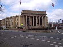

The downtown area is located between Memorial Square, formed by the intersection of Concord St. and Union Ave., to the north and its mirror intersection at the junction of Irving St. and Hollis St. on the south end. The area is bisected by Waverly St. (Route 135) and the MBTA Commuter Rail tracks. The anchoring structure of Downtown is the town hall, The Memorial Building.[62] From 2015 to 2016, the whole area underwent a multimillion-dollar reconstruction of the intersection of Union Ave. and Concord St. that removee the traffic circle and replaced it with a signal controlled intersection. Additional lights were installed at the Irving St./Hollis St. intersection, while older signals in the area were upgraded. All sidewalks in the area were to be replaced, lighting upgraded, and new amenities such as seating and bicycle racks were also installed. The project was scheduled to begin in 2012, but has been delayed to 2014–2015.[63][64] Further delays pushed the project into 2015 due to needed electrical utility upgrades and replacement.[65]
South Framingham became the commercial center of the town with the advent of the railroad in the 1880s. It eventually came to house Dennison Manufacturing and the former General Motors Framingham Assembly plant, but the area underwent a financial downturn after the closure of these facilities during the late 1980s.[66] An influx of Hispanic and Brazilian immigrants helped to revitalize the district starting in the early 2000s. Along with Brazilian and Spanish oriented retail shops, there are restaurants, legal and financial services, the town offices and library, an art museum, police headquarters, and the local branch of the Social Security Administration. Several Asian and Indian stores and restaurants add to the rich ethnic flavor of the area, and many small businesses, restaurants and automotive-oriented shops line Waverly St. from Natick in east to Winter St. in the west.[67]
In 2006, the Fitts Market & Hemenway buildings façades underwent a restoration project; these newly renovated structures were awarded a 2006 Massachusetts Historical Commission Preservation Award in the Restoration and Rehabilitation Category.[68] In addition, several retail and housing projects involving the Arcade Building and the former Dennison Building Complex are in the planning stages or under construction.[69][70]
West Framingham
The business section on the West Side of Framingham runs primarily along Route 9, starting at Temple St.; it is dominated by two large office/industrial parks: the Framingham Industrial Park on the north side of Route 9 and the Framingham Technology Park on the south side, both on the Ashland/Southborough border. Bose, Staples Inc and Applause have their world headquarters in these parks,[71] as does convenience store chain Cumberland Farms; in addition, Netezza, Genzyme, Capital One, CA Technologies, ITT Tech and the local paper, The MetroWest Daily News, all have major facilities located there. Two of Framingham's seven major auto dealerships are also located in West Framingham: Ford and Toyota/Scion.[72][73]
The large tracts of multi-story apartment and condominium complexes line both sides of Route 9 from Temple St. to the industrial parks. These buildings represent the majority of Framingham's multi-family dwellings, and along with the business complexes, helped create a large network of support services on the West Side: Framingham's second Super Stop & Shop supermarket,[74] dozens of restaurants and pubs, Sheraton[75] and Residence Inn by Marriott[76] hotels and a large day-care facility all are in the two-mile (3 km) section of Route 9 from Temple St. to Ashland.
Villages and Route 9

The Framingham Centre Common Historic District is the physical and historic center of town. Formed at the junctions of Worcester Rd. (Route 9), Pleasant St. (Route 30), High St., Main St. and Edgell Rd.[77] the dominating presence is Framingham State University. The school is home to several thousand students, about one third of whom live on campus.[78] In the late 1960s, MassHighway replaced the intersection with an overpass, depressing Route 9 below the local roads, and destroying the south half of the old Center retail district. The remaining half houses several small stores, restaurants, realtors and legal offices. The old Boston and Worcester Street Railway depot, on the east side of the Center, was converted into a strip mall in the early 1980s and houses the Center Postal Station (01703) and several small stores.[79] The Center is rounded out by One and Two Edgell Rd. (two small retail/office buildings), the historic village hall,[80] the Jonathan Maynard Building (a former school converted to an office building which now houses most of the school district's administration), the Framingham History Center (formerly the Framingham Historical Society and Museum),[81] several banks, a Chinese restaurant, the American Medical Response paramedic station and McCarthy Office Building.
The village of Nobscot, located at the intersection of Water St., Edmands Rd. and Edgell Rd. near Nobscot Hill, and the Pinefield/Saxonville villages, located where Concord St., Water St., and Central St. intersect,[82][83] are home to several small office buildings, strip malls and gas stations. in 2016, the town moved its satellite branch of the public library named for Christa McAuliffe from Saxonville to a new facility across from the Hemingway School in Nobscot. Saxonville is the home of the former Roxbury Carpet Company buildings, now an industrial park, and is one of the town's historical districts.
In addition, the section of Route 9 from the Route 126 overpass to the Main St./Edgell Rd. beetleback in Framingham Center is heavily developed. Three car dealerships, Acura, Chevrolet and Nissan, several strip malls of varying sizes, many small apartment complexes, several small office complexes and other small shops and restaurants make Route 9 the main commercial thoroughfare in Framingham.
Finally, there are several other small retail areas and facilities spread throughout the town, e.g. near Mt Wayte Ave. and Franklin St.; the intersection of Concord St. and Hartford St.; and along School St., near Hamilton St.
Healthcare
- Hospitals: MetroWest Medical Center (formerly Framingham Union Hospital, also includes Leonard Morse Hospital campus in Natick)
- Nursing homes: St. Patrick's
Media
Newspapers and websites
The Town of Framingham is served by:
- Framingham Online News, a local news and community information website.[84]
- The MetroWest Daily News, a daily broadsheet.[85]
- The Framingham Tab, a weekly local current events tabloid.[86]
- The Boston Globe provides a regional edition called Globe West that covers Framingham and the MetroWest area.[87]
- Boston.com has a Your Town website that covers Framingham.[88]
- A Semana,a weekly, Brazilian-Portuguese language local current events tabloid.[89]
- The Gatepost – a weekly student run newspaper published by Framingham State University.[90]
Television and cable
Framingham has a public, educational, and government access (PEG) cable TV channel and local origination television station called Access Framingham (formerly FPAC-TV),[91] that airs on Channel 9 Comcast, Channel 3 RCN and Channel 43 Verizon. Residents can create and produce their own television programs that reflect the personality of the community, and have them cablecast on the public-access television cable TV channels.
Framingham High School has a student-run television station, FHS-TV, that broadcasts locally; "Flyer News", its morning news program, has won 11 National High School Emmy Awards.
The Town of Framingham operates the Government Channel shown on Comcast channel 99, RCN 13, and Verizon 42. The Government Channel operation provides programming sponsored by or for the Town of Framingham. Commission meetings are cablecast live to inform residents and encourage participation in local government. Some of the programming provided, keeps residents abreast of road closings, construction updates, recycling efforts, public safety information, and special events in the community. The Government Channel is committed to making local government more accessible to all residents. More information is available at www.framinghamtv.com
Radio
- WXKS (AM 1200) is an AM broadcasting station featuring talk radio and religious programming. Owned by iHeartMedia and licensed to Newton, Massachusetts with studios on 99 Revere Beach Parkway in Medford, Massachusetts;[92]
- WSRO (AM 650) is an AM broadcasting station featuring Portuguese-language programming that leases studio and tower space from WXKS. Owned by the Langer Broadcasting Group, LLC and licensed to Natick, Massachusetts with studios on 100 Mount Wayte Ave in Framingham;[92][93]
- WQOM (AM 1060) is an AM broadcasting station featuring business talk radio programming that leases studio and tower space from WXKS. Owned by the Langer Broadcasting Group, LLC and licensed to Ashland, Massachusetts with studios on 100 Mount Wayte Ave in Framingham;[92][94]
- WDJM-FM (91.3 FM) is Framingham State College's FM broadcasting station that features an open format with progressive rock, hip-hop and rap. It is owned by the Commonwealth of Massachusetts and is licensed to Framingham, Massachusetts with studios at 100 State St. in Framingham;[95]
- Framingham Amateur Radio Association[96] is the local amateur radio enthusiasts group.
Film
In the spring of 2016, the town of Framingham was used for the film Patriots Day, about the Boston Marathon bombing, starring Mark Wahlberg, John Goodman, Kevin Bacon and J.K. Simmons.[97]
Utilities
- Telephone poles – The majority of telephone poles serving Framingham are owned by either Eversource or Verizon.
- Electrical distribution – Framingham is served by Eversource for electricity distribution, customers are free to purchase electricity from individual suppliers.
- Telephone, CATV, and data services – The majority of Framingham is served by three vendors that provide telephone, cable TV, and internet services. Other smaller or specialized companies provide DSL, ISDN, POTS, and CTI services.
- Natural gas – Framingham is served by National Grid's Keyspan division and Eversource for piped in natural gas.
- Water and sewer – Framingham is part of the MWRA and the town owns its water and sewer mains. The northwest corner of town, west of Edgell Road and north of Route 30, primarily relies on wells and septic systems for private residences.
Points of interest
Framingham features dozens of athletic fields and civic facilities spread throughout the town in schools and public parks.[98] Many of the recreational facilities were constructed by the Civilian Conservation Corps during the New Deal.
Culture
| Wikimedia Commons has media related to Framingham History Center. |
- Amazing Things Arts Center[99]
- Framingham Community Theater[100]
- Framingham History Center (formerly the Framingham Historical Society and Museum)[101]
- Danforth Museum[102]
- Performing Arts Center of Metrowest
- Metrowest Youth Symphony Orchestra[103]
- Pike Haven Homestead was built in 1693 by Jeremiah Pike. He and his descendants were town and militia officers, yeomen, and makers of spinning wheels in the colonial period. This house had been occupied by the same family for eight generations.[104]
Parks
- Bowditch Field is the town's main athletic facility. It is located on Union Avenue midway between Downtown and Framingham Center and was the main athletic facility for the town. It houses a large multi-purpose football stadium that included permanent bleachers on both sides of the field. There is still a baseball field, tennis courts, a track and field practice area, and the headquarters of the town Parks Department. Bowditch, along with Butterworth and Winch Parks, were all built during the Great Depression of the 1930s as WPA projects. It underwent a complete renovation/reconstruction in 2010.[105][106]
- Butterworth Park is located at the corner of Grant St and Arthur St. The park occupies a square block near downtown. The park has includes a baseball stadium that includes permanent bleachers on one side of the field, a basketball court and a tennis court. There is street parking available on three sides.
- Winch Park is the sister park to Butterworth and is located in Saxonville adjacent to the Framingham High School. It includes a baseball stadium that includes permanent bleachers on one side of the field, a basketball court, tennis courts and two large practice fields used for football, soccer and lacrosse. There are two additional multi-use fields located on the other side of the high school's gymnasium building.
- Callahan State Park is a large state park run by the DCR located in North Framingham in the northwest corner of town.[107]
- Cochituate State Park on Lake Cochituate has a small section in Framingham where Saxonville Beach is located on the north western shore of the lake.[108]
- Danforth Park located on Danforth Street, not far from the Wayland town line. The small park has playground with a half basketball court and a small baseball/kickball field.
- Framingham Common is located in Framingham Center in front of the old Town Hall along Edgell Road and Vernon Street. It features the town Christmas Tree and an outdoor stage used for concerts and other fair weather events. It is a favorite of the students of Framingham State University, and the site of their annual graduation ceremonies.[109]
- Cushing Park on the South Side is a passive recreational area. The Framingham Peace and 9/11 Memorials are located within the park across the street from Farm Pond, along with the Cushing Chapel. After World War II ended, this land used to be the Cushing Veterans Hospital.[110]
- Long Athletic Complex On the south side of Framingham, near downtown the complex is the host of three little league baseball diamonds (Carter, Tusconi, Merloni), two Babe Ruth baseball fields (one being Long field), a softball field, outdoor basketball court, and two concession stands. The complex is surrounded by Keefe Tech High School, Loring Arena, and Barbari Elementary School. All of the fields have lights, and they host almost all of Framingham's Little League games. Long field is the host of JV high school games as well as a majority of the Framingham Babe Ruth games. The concession stands are both non-profit and all the money goes back towards the Framingham baseball league.
Conservation land
- Framingham has about 400 acres (1.6 km2) of land that has been placed into public conservation.[111]
- The Wittenborg Woods was donated to the town in 1999 by Harriet Wittenborg. The properties were originally purchased from Henry Ford in the 1940s. Henry Ford owned all of the land around the Wayside Inn in nearby Sudbury, and Harriet (and her husband) were required to interview with Mr. Ford to determine if they would be good stewards of the land.[112]
- The Morency Woods is a parcel of land that is physically located in Natick, Massachusetts on the Framingham border, but which is owned by the town of Framingham. This forested land was used as a sewer bed up until the mid-1940s and was placed into conservation in 2001.[113]
- The Sudbury Valley Trustees has approximately 200 acres (0.8 km2) of land in North Framingham and along the Sudbury River in a private conservation trust.[114]
Recreation

- Garden in the Woods, operated by the New England Wild Flower Society,[115] is a botanical garden that features the largest landscaped collection of native wildflowers in New England. It is located in Nobscot, off of Hemenway Road.
- Framingham Country Club, located along Salem End Road on the South Side, is a private club that features an 18-hole course with 6,580 yards (6,017 m) of golf from the longest tees for a par of 72.
- Millwood Farms Golf Course off Millwood Street is a public 14-hole, par 53 golf course. Originally a 9-hole course, it was expanded to 14 holes in the late 1970s. Attempts to purchase land for a full 18-hole were unsuccessful.
- Nobscot Scout Reservation is a private facility owned by the Knox Trail Council[116] of the Boy Scouts of America and is open to the public during most of the year.
- The town has several public beaches including Saxonville beach on Lake Cochituate, Washakum Beach on Lake Washakum, and the beach at Learned Pond.
- The former Cushing hospital grounds serve as walking, biking, rollerblading, and picnic areas.
- Farm Pond, located in South Framingham, once used to host Fourth of July Fireworks, now serves as a picnic area.
- Edward F. Loring Skating Arena,[117] located near Farm Pond at the corner of Fountain and Dudley Roads, is a municipal skating arena for area groups on a rental basis and public skating and stick time is available September through April.
Places of worship
Notable people
Politics

- Crispus Attucks, killed in the Boston Massacre[118]
- Deborah D. Blumer, Massachusetts State Representative for Framingham (2001–2006).
- Mary Beth Cahill, campaign manager for John Kerry's bid for presidency.
- Adam Schiff, United States Representative for California
- Josiah Trowbridge, former Mayor of Buffalo, New York
Sports
- Blake Bellefeuille, NHL forward
- David Blatt, Israeli-American basketball player and coach (most recently, for the Cleveland Cavaliers)
- Ron Burton, former NFL running back for the Boston Patriots, 1960 to 1965
- Carl Corazzini, NHL Hockey Player, Boston Bruins, Chicago Blackhawks, Detroit Red Wings, Edmonton Oilers
- Rich Gedman, former Major League Baseball catcher for the Boston Red Sox, 1980 to 1990
- Toby Kimball, NBA player for the Boston Celtics, San Diego Rockets, Milwaukee Bucks, Kansas City Kings, Philadelphia 76ers, and the New Orleans Jazz[119]
- Lou Merloni, Major League Baseball player for the Boston Red Sox, 1998 to 2003
- John Stagikas, pro wrestler
- Mark Sweeney, Major League Baseball player
- Pie Traynor, former Major League Baseball player, now in the Major League Baseball Hall of Fame
- Kevin Nee, Professional Strongman. Youngest man ever to become professional Strongman.
- Tal Smith, Baseball Executive, former General Manager of the Houston Astros.
- Danny O'Connor, American professional boxer in the Light Welterweight division.
Arts and sciences
- Ezra Ames (1768–1836), portrait painter in the 18th–19th centuries[120]
- Anthony Barbieri, comedy writer
- Daniel Belknap (1771–1815), composer
- Michael J. Clouse, songwriter, music producer]
- Nancy Dowd, Academy Award winning screenwriter for Coming Home (1978)
- Alexander Rice Esty (1826–1881) architect of New England churches
- Ginger Fish, member of Marilyn Manson
- Dr. Solomon Carter Fuller, a pioneering African-American in the field of psychology and Alzheimer's disease
- Meta Vaux Warrick Fuller, Prominent African-American sculptor and artist from the 1920s
- Leila Goldkuhl, fashion model
- David Hayes – Music Director of The Philadelphia Singers, Director of Orchestral and Conducting Studies at Mannes College The New School for Music
- Og Mandino (1923–1996) author
- Joe Maneri (1927–2009), noted classical composer and jazz improviser
- Christa McAuliffe, teacher, astronaut killed in the Challenger disaster
- Jo Dee Messina, Country music singer
- Gordon Mumma, composer
- Edward Lewis Sturtevant, botanist, scientist, author
- Nancy Travis, actress
- Rob Urbinati, stage director, playwright
Media
- Tom Caron, New England Sports Network baseball analyst
- Jordan Rich, WBZ (AM) Radio host
- Katie Nolan, Fox Sports 1 Sports Entertainment
Other
- Gerald Fitzgerald, Roman Catholic priest
- Richard W. Higgins, pilot in the USAF
- Donald K. Muchow, Chief of Chaplains of the U.S. Navy
- John Nixon, General in the Continental Army during the American Revolution
- Charles Henry Parkhurst, clergyman, social reformer
- William A. Rice, Roman Catholic bishop in Belize
Sister cities
See also
References
- ↑ "Census 2010: Massachusetts". Usatoday.Com. Retrieved 2012-01-04.
- ↑ http://www.sec.state.ma.us/census/middlesex.htm
- ↑ "Money Magazine Snapshots Link". CNN.
- ↑ "Money Magazine Top 100 Link". CNN.
- ↑ General Gage's Instructions, Boston: John Gill, 1779.
- ↑ Samuel Adams Drake, History of Middlesex County, Massachusetts (Boston: Estes & Lauriat, 1880), vol. 1, p. 443
- ↑ Donald Yacovone, "A Covenant with Death and an Agreement with Hell", at http://www.masshist.org/objects/2005july.cfm
- 1 2 "US Gazetteer files: 2010, 2000, and 1990". United States Census Bureau. 2011-02-12. Retrieved 2011-04-23.
- ↑ "TOTAL POPULATION (P1), 2010 Census Summary File 1". American FactFinder, All County Subdivisions within Massachusetts. United States Census Bureau. 2010.
- ↑ "Massachusetts by Place and County Subdivision - GCT-T1. Population Estimates". United States Census Bureau. Retrieved July 12, 2011.
- ↑ "1990 Census of Population, General Population Characteristics: Massachusetts" (PDF). US Census Bureau. December 1990. Table 76: General Characteristics of Persons, Households, and Families: 1990. 1990 CP-1-23. Retrieved July 12, 2011.
- ↑ "1980 Census of the Population, Number of Inhabitants: Massachusetts" (PDF). US Census Bureau. December 1981. Table 4. Populations of County Subdivisions: 1960 to 1980. PC80-1-A23. Retrieved July 12, 2011.
- ↑ "1950 Census of Population" (PDF). Bureau of the Census. 1952. Section 6, Pages 21-10 and 21-11, Massachusetts Table 6. Population of Counties by Minor Civil Divisions: 1930 to 1950. Retrieved July 12, 2011.
- ↑ "1920 Census of Population" (PDF). Bureau of the Census. Number of Inhabitants, by Counties and Minor Civil Divisions. Pages 21-5 through 21-7. Massachusetts Table 2. Population of Counties by Minor Civil Divisions: 1920, 1910, and 1920. Retrieved July 12, 2011.
- ↑ "1890 Census of the Population" (PDF). Department of the Interior, Census Office. Pages 179 through 182. Massachusetts Table 5. Population of States and Territories by Minor Civil Divisions: 1880 and 1890. Retrieved July 12, 2011.
- ↑ "1870 Census of the Population" (PDF). Department of the Interior, Census Office. 1872. Pages 217 through 220. Table IX. Population of Minor Civil Divisions, &c. Massachusetts. Retrieved July 12, 2011.
- ↑ "1860 Census" (PDF). Department of the Interior, Census Office. 1864. Pages 220 through 226. State of Massachusetts Table No. 3. Populations of Cities, Towns, &c. Retrieved July 12, 2011.
- ↑ "1850 Census" (PDF). Department of the Interior, Census Office. 1854. Pages 338 through 393. Populations of Cities, Towns, &c. Retrieved July 12, 2011.
- ↑ "American FactFinder". United States Census Bureau. Retrieved 2008-01-31.
- ↑ "Brazilian is not Hispanic".
- ↑ "US Census Demographic data for 2000".
- ↑ Joel Millman (February 16, 2006). "Immigrant groups put new spin on cleaning niche". The Wall Street Journal – via Pittsburgh Post-Gazette.
- ↑ "USCCB Migration & Refugee Services".
- ↑ "Brazilian Immigration to Massachusetts: Newcomers to a Foreign Land" (PDF).
- ↑ "Framingham Housing Plan Population Profile" (PDF).
- ↑ "Framingham Housing Plan".
- ↑ "Sudbury Reservoirs on the DCR web site".
- ↑ "Edgewater Hills on EveryAptMapped.com".
- ↑ "Edgewater Village on EveryAptMapped.com".
- ↑ "Edgewater Terrace on BostonApartments.com".
- ↑ Framingham Precinct Information
- ↑ About town government
- ↑ Framingham Standing Committees
- ↑ Framingham Boards and Commissions
- ↑ Historic time line of Framingham on Framingham.com
- 1 2 Framingham Public School District Massachusetts Department of Elementary and Secondary Education
- ↑ Contact Information Framingham Public School District
- ↑ South Middlesex Regional Vocational Technical Massachusetts Department of Elementary and Secondary Education
- ↑ Christa McAuliffe Regional Charter Public (District) Massachusetts Department of Elementary and Secondary Education
- ↑ Department of Housing and Community Development
- ↑ "Changes to Transit Service in the MBTA district" (PDF).
- ↑ "MBTA Map of Commuter Rail service in Massachusetts, New Hampshire and Rhode Island".
- ↑ "Logan Express Framingham".
- ↑ Mitch Evich (February 1, 2007). "Framingham forms regional transit authority". Massachusetts Municipal Association. Retrieved 2007-09-12.
- ↑ "Lift Bus routes and schedules".
- ↑ Andrew J. Manuse (July 22, 2007). "Southborough-Marlborough "model" to be picked up by MetroWest transit authority". The MetroWest Daily News. Retrieved 2007-09-12.
- ↑ "Park & Ride locations in Massachusetts".
- ↑ "Map showing park and ride lot at Shoppers World" (PDF).
- ↑ "Map showing Park & Ride in West Framingham" (PDF).
- ↑ "Other Development in the Golden Triangle on Framingham/Natick Retail".
- ↑ "History of Shoppers World on Massmoments.org".
- ↑ "The Marshals Mall on Framingham/Natick Retail".
- ↑ "Caldor on Framingham/Natick Retail".
- ↑ "Bradlees on Framingham/Natick Retail".
- ↑ "History of the Route 30 Mall on Framingham/Natick Retail".
- ↑ "the Framingham Mall on Framingham/Natick Retail".
- ↑ "The Verizon Building on Framingham/Natick Retail".
- ↑ "The Natick Mall on Framingham/Natick Retail".
- ↑ "Sherwood Plaza on Framingham/Natick Retail".
- ↑ "The Evolution of the Cloverleaf Mall on Framingham/Natick Retail".
- ↑ "Bid Adieu Shoppers World".
- ↑ "Downtown Framingham Economic Development Strategic Plan on Framingham.com".
- ↑ "Route 126 Downtown Roadway Improvement Project". Town of Framingham. Retrieved July 13, 2014.
- ↑ Ameden, Danielle (September 28, 2012). "Roundabout or traffic lights for downtown Framingham". Metrowest Daily News. Retrieved July 13, 2014.
- ↑ Petroni, Susan (23 April 2015). "Where to Expect Delays Due to Construction in Downtown Framingham". Retrieved 30 April 2016.
- ↑ "Downtown Revitalization in Framingham plan on STEPPS.com".
- ↑ "Shop Downton Guide on Framingham.com".
- ↑ "2006 MHC Preservation Award Winners".
- ↑ "Framingham Arcade reconstruction project designed Beals and Thomas". Archived from the original on February 3, 2007.
- ↑ "The Residences at Dennison Triangle on Framingham.com". Archived from the original on October 22, 2006.
- ↑ "Local Bus Schedule with maps of these Company HQs" (PDF). Archived from the original (PDF) on June 27, 2007.
- ↑ "Bernardi Toyota".
- ↑ "Framingham Ford".
- ↑ "Stop and Shop stores in Framingham".
- ↑ "Sheraton Framingham on Sheraton.com".
- ↑ "Framingham Residence Inn on Marriott.com".
- ↑ "Map of Framingham Center on HomeTownLocator.com".
- ↑ "Framingham State College's home page".
- ↑ "Boston & Worcester trolley on historicframingham".
- ↑ "Village Hall home page".
- ↑ "Framingham History Center home page".
- ↑ "Shopping Nobscot on framingham.com".
- ↑ "Shopping Saxonville on framingham.com".
- ↑ "Framingham Online News".
- ↑ "The MetroWest Daily News".
- ↑ "The Framingham Tab".
- ↑ "The Boston Globe West regional edition". August 13, 2010.
- ↑ "Your Town Framingham". The Boston Globe. May 17, 2011.
- ↑ "Jornal A Semana Brazilian Newspapers".
- ↑ "Gatepost". Framingham State University. Retrieved May 2015. Check date values in:
|access-date=(help) - ↑ "Access Framingham (formerly FPAC-TV)".
- 1 2 3 "The Boston Radio Dial: WKOX(AM)". The Archives @ BostonRadio.org. February 25, 2007. Retrieved 2007-09-16.
- ↑ "The Boston Radio Dial: WSRO(AM)". The Archives @ BostonRadio.org. February 25, 2007. Retrieved 2007-09-16.
- ↑ "The Boston Radio Dial: WBIX(AM)". The Archives @ BostonRadio.org. February 25, 2007. Retrieved 2007-09-16.
- ↑ WDJM staff (September 12, 2007). "WDJM 91.3 MySpace page". MySpace.com. Retrieved 2007-09-16.
- ↑ "Framingham Amateur Radio Association".
- ↑ http://boston.cbslocal.com/2016/04/19/patriots-day-mark-wahlberg-watertown-framingham/
- ↑ "Listing of public parks run by the Framingham Parks and Recreation Department".
- ↑ "Amazing Things Arts Center".
- ↑ "Framingham Community Theater".
- ↑ "Framingham Historical Society and Museum".
- ↑ "The Danforth Museum".
- ↑ "Metrowest Youth Symphony Orchestra".
- ↑ Sign erected at the site (corner of Belknap Rd and Grove St) by Massachusetts Bay Colony Tercentenary Commission
- ↑ "Framingham's Bowditch Field renovation ready to kick off". The MetroWest Daily News. October 29, 2009. Retrieved 2010-03-02.
- ↑ "Bowditch Field Athletic Complex Renovations".
- ↑ "Callahan State Park on the DCR web site".
- ↑ "Cochituate State Park on the DCR web site".
- ↑ "Framingham State College website".
- ↑ "Framingham Cultural Directory".
- ↑ "Framingham Conservation Land".
- ↑ "Wittenborg Woods".
- ↑ "Arthur-Morency Woods".
- ↑ "Map of SVT Properties in Framingham".
- ↑ "New England Wildflower Society".
- ↑ "Knox Trail Council".
- ↑ "Edward F. Loring Skating Arena".
- ↑ Crispus Attucks from Africans in America; Crispus Attucks- The Real Story
- ↑ "Toby Kimball Past Stats, Playoff Stats, Statistics, History, and Awards". Databasebasketball.com. Retrieved 2010-03-03.
- ↑ Who Was Who in America, Historical Volume, 1607–1896. Marquis Who's Who. 1967.
- ↑ "FLAME". framingham.com.
- ↑ Mineo, Liz (October 22, 2007). "Brazilian delegation coming to MetroWest". The MetroWest Daily News. Retrieved 2008-09-18.
Further reading
- 1871 Atlas of Massachusetts. by Wall & Gray. Map of Massachusetts. Map of Middlesex County.
- Old USGS maps of Everett.
- Ballard, William, A Sketch of the History of Framingham, published 1827, 71 pages.
- Barry, William, History of Framingham, Massachusetts, published 1847, 456 pages.
- Drake, Samuel Adams (compiler), Volume 1 (A-H), Volume 2 (L-W), published 1879–1880. 572 and 505 pages. Framingham article by Rev. Josiah Howard Temple in volume 1 pages 435–453.
- Parr, James; Swope, Kevin A., Framingham Legends & Lore, History Press, 2009. ISBN 978-1-59629-565-0
External links
| Wikimedia Commons has media related to Framingham, Massachusetts. |
| Wikivoyage has a travel guide for Framingham. |
- Town government website
- Choose Framingham website(Town information)
- Community website
- Framingham History Center
- Framingham Department of Housing and Community Development Profile. Executive Office of Housing and Economic Development. Commonwealth of Massachusetts.
- Framingham Public School District
- The History of Framingham's Shoppers' World
- Framingham Raised Tobacco Buying Age to 21
| Articles |  Minuteman statue at the intersection of Main St. and Union Ave. | ||||||||||||||||||||||
|---|---|---|---|---|---|---|---|---|---|---|---|---|---|---|---|---|---|---|---|---|---|---|---|
| Related Subjects |
| ||||||||||||||||||||||
| Businesses | |||||||||||||||||||||||
| People | |||||||||||||||||||||||
| Neighboring Communities | |||||||||||||||||||||||