Interstate 95 in Massachusetts
| ||||
|---|---|---|---|---|
 | ||||
| Route information | ||||
| Maintained by MassDOT | ||||
| Length: | 92 mi (148 km) | |||
| Existed: | 1957 – present | |||
| Major junctions | ||||
| South end: |
| |||
| North end: |
| |||
| Location | ||||
| Counties: | Bristol, Norfolk, Middlesex, Essex | |||
| Highway system | ||||
| ||||
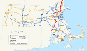
Interstate 95 (I-95) is a major highway on the East Coast of the United States,[1] paralleling the Atlantic Ocean from Florida to Maine. The Massachusetts portion of the highway enters from the state of Rhode Island in Attleboro and travels in a northeasterly direction to the junction with Route 128 in Canton. As the original plans for I-95 (which would have taken it through central neighborhoods of Boston and the northern suburbs of Saugus and Lynn) were canceled, the highway follows the Route 128 loop around the Greater Boston area to Peabody. From there, I-95 splits from Route 128 and turns north towards the Merrimack River. I-95 enters New Hampshire from Salisbury.
Route description
Attleboro to Canton
I-95 crosses the state border from Pawtucket, Rhode Island into Attleboro as a six-lane highway, with the first northbound exits, 2A and 2B, providing access to Route 1A and nearby U.S. Route 1 near the border. (There is an Exit 1, but it is a southbound-only exit connecting to US-1 south into Rhode Island.) Exits 3–5 also serve the Attleboro area, with Exit 4 at the northern terminus of Interstate 295.
Exits 6A and 6B in Mansfield provide access to Interstate 495, the "outer circumferential" beltway around metro Boston. I-495 provides northbound connections to Worcester, the Massachusetts Turnpike, and the western part of the state, and southbound connections to Cape Cod. Mansfield is home to the Comcast Center, a Live Nation-owned amphitheatre that hosts numerous concert events, and the TPC Boston, a PGA player's club that hosts the Deutsche Bank Championship yearly. The two venues are located near I-95's interchanges with Route 140.
I-95 continues northward into Foxborough, home of Gillette Stadium, located on US-1 and accessible from Exit 9. The interstate continues through Sharon, it then enters the metro Boston area and the towns of Walpole, and Norwood, before entering Canton, where it meets Interstate 93 at its southern terminus (Exit 12).
Canton to Peabody (Route 128)
Upon interchanging with I-93, I-95 loops around to the west, taking over the roadbed from I-93 and joining US-1 southbound in a wrong-way concurrency. Route 128 begins here as well. The highway enters Westwood next, with US-1 leaving the freeway near the Dedham town line (at Exit 15B) to parallel I-95 back to the south. I-95 and Route 128 makes its way around metro Boston, passing through Dedham, Needham, and Wellesley, where the freeway has an interchange with Route 9 at Exit 20, and the freeway widens to eight lanes. Then the highway passes through Newton, then enters Weston and has a large interchange with the Massachusetts Turnpike (I-90, at Exit 25) that provides connections to nearby Route 30. There is a fourth lane after the interchange with Rt 9. Exits 23, 24, and 25 are one combined exit northbound.
I-95 and Route 128 are due west of Boston at this point and begin to turn to the northeast, serving the city of Waltham and the town of Lexington along the way. The freeway has an interchange with Route 2 (Concord Turnpike) at Exit 29. Upon entering the town of Burlington, I-95 and Route 128 have an interchange with U.S. Route 3, the Northwestern Expressway, at Exit 32A. US-3 provides a direct freeway connection with the Lowell and Nashua, New Hampshire metro areas. Access to the Middlesex Turnpike and Burlington retail district is facilitated at this interchange as well. US-3 south briefly joins the freeway in another wrong-way multiplex in order to connect with its old alignment, leaving at Exit 33A. I-95 and Route 128 continue northeast through the city of Woburn and into Reading.
In Reading, I-95 and Route 128 once again have an interchange with I-93. After crossing, I-93, the now six-lane highway continues to the northeast, serving the towns of Wakefield and Lynnfield before crossing into Peabody, where Route 128 leaves I-95 at Exit 45 as its own freeway towards Gloucester. At this interchange, six lanes of through traffic are designated for Route 128 while four lanes split off as I-95.
Peabody to Salisbury
After leaving Route 128, I-95 expands back to six lanes and then to eight lanes at the partial interchange with US 1 (Exit 46) about 1 mile north of Route 128 and heads north through the less densely populated northeastern portion of the state. The freeway serves the communities of Danvers, Boxford, Georgetown, Rowley, Newbury, West Newbury, Newburyport, Amesbury, and Salisbury. Traffic density is generally low on this 25-mile (40 km) stretch of freeway. After Exit 57, the highway narrows to six lanes until the I-495 interchange expands it back to eight lanes.
I-495 has its northern terminus at I-95 Exit 59 just south of the New Hampshire state line, a Y-interchange that merges I-495 onto I-95. Southbound access is possible via Exit 58 for Route 110 westbound, which leads to I-495's Exit 55 (I-495's last exit before I-95). The northernmost exit in Massachusetts is Exit 60, providing access to Main Street towards Amesbury and Route 286 towards Salisbury Beach and Hampton Beach (the southbound ramp starts in New Hampshire). After crossing underneath the connecting roads, I-95 crosses the state line into Seabrook, New Hampshire.
History
The original plans called for I-95 to run through downtown Boston. The highway would have progressed from Route 128 and Readville, followed the Southwest Corridor, joined the Inner Belt in Roxbury, heading east, and joining the Southeast Expressway at South Bay, then north to the Central Artery at the South Station interchange with the Massachusetts Turnpike/Interstate 90, and connecting with the Northeast Expressway at the Charlestown banks of the Charles River.
However, due to pressure from local residents, all proposed Interstate Highways within Route 128 were canceled in 1972 by Governor Francis Sargent with the exception of Interstate 93 to Boston. The only sections of I-95 completed within the Route 128 beltway by the Massachusetts Department of Transportation were the segment known as the Northeast Expressway north from Charlestown to Saugus, which is now part of U.S. Route 1, and the Central Artery, which cut the North End neighborhood from downtown Boston proper until the Thomas P. O'Neill Jr. Tunnel essentially submerged the old Central Artery's traffic load below ground level in 2003. The Southwest Expressway and the Inner Belt highways were among the Sargent-canceled highways.
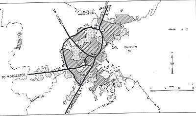
Between 1972 and 1974, plans were to extend I-95 along a northerly extension of the Northeast Expressway to Route 128 in northwestern Danvers. During this time, I-95 was officially routed along Route 128 from Canton to Braintree and north along the Southeast Expressway (also designated Route 3), from Braintree to Boston, then following the Central Artery, and continuing along the Northeast Expressway in Boston, Chelsea and Revere.
When the Northeast Expressway extension (between Saugus and Danvers) was canceled in 1974, I-95's route shifted to its current routing along the perimeter highway (Route 128) and I-93 was extended to meet I-95 in Canton. For several decades, plans for the abandoned roadways could still be seen going from the end of the Northeast Expressway to the Saugus River in Saugus in the form of a graded but unpaved roadbed. Much of this was removed during the early 2000s. At the US 1/Route 60 interchange, one can still see unused bridges and ghost ramps that were originally intended to carry I-95.
Exit list
All interchanges were to be renumbered to mileage-based numbers under a project scheduled to start in 2016, however this project has been indefinitely postponed.[2][3]
| County | Location[4] | mi[4] | km | Old exit | New exit[5][6][7] | Destinations[5][6][7] | Notes |
|---|---|---|---|---|---|---|---|
| Bristol | Attleboro | 0.000 | 0.000 | – | Continuation from Rhode Island | ||
| 0.499 | 0.803 | 1 | Southbound exit and northbound entrance | ||||
| 1.199 | 1.930 | 2A | |||||
| 1.213 | 1.952 | 2B | |||||
| 4.197 | 6.754 | 3 | Signed as Exits 3A (east) and 3B (west) southbound | ||||
| 5.860 | 9.431 | 4 | Northern terminus of I-295, exits 2A-B | ||||
| North Attleborough | 6.918 | 11.133 | 5 | ||||
| Mansfield | 11.562 | 18.607 | 6A | ||||
| 11.604 | 18.675 | 6B | |||||
| Norfolk | Foxborough | 12.944 | 20.831 | 7 | Signed as Exits 7A (south) and 7B (north) | ||
| Sharon | 16.626 | 26.757 | 8 | South Main Street – Sharon | Northbound signage | ||
| Mechanic Street – Foxboro | Southbound signage | ||||||
| 19.215 | 30.924 | 9 | Northbound signage | ||||
| Southbound signage | |||||||
| Walpole | 21.096 | 33.951 | 10 | Coney Street – Walpole, Sharon | Southbound exit and northbound entrance | ||
| Norwood | 23.269 | 37.448 | 11 | Neponset Street – Canton, Norwood | Signed as Exits 11A (east) and 11B (west) | ||
| Canton | 26.740 | 43.034 | 63 | 12 | Left exit southbound; southern terminus of I-93; Exit 1 on I-93; southern end of wrong-way concurrency with US 1 Southern terminus of Route 128 | ||
| Dedham | 27.352 | 44.019 | 62 | 13 | University Avenue – MBTA / Amtrak station | ||
| Westwood | 28.627 | 46.071 | 61 | 14 | East Street / Canton Street | ||
| Dedham | 29.300 | 47.154 | 60 | 15A | |||
| 29.316 | 47.180 | 15B | Northern end of wrong-way concurrency with US 1 | ||||
| 30.823 | 49.605 | 59 | 16 | Signed as Exits 16A (east) and 16B (west) | |||
| 32.388 | 52.123 | 58 | 17 | Norfolk County Correctional Center is in the median of Route 128, access from Route 135 Eastern terminus of Route 135 | |||
| Needham | 32.873 | 52.904 | 57 | 18 | Great Plain Avenue – West Roxbury | ||
| 35.730 | 57.502 | 56 | 19 | Highland Avenue – Newton Highlands, Needham | Signed as Exits 19A (Newton Highlands) and 19B (Needham) | ||
| Wellesley | 36.798 | 59.221 | 55 | 20 | Signed as Exits 20A (east) and 20B (west) | ||
| Middlesex | Newton | 38.175 | 61.437 | 54 | 21 | Signed as Exits 21A (east) and 21B (west, with Exit 22) southbound | |
| 38.519 | 61.990 | 53 | 22 | Grove Street – MBTA Station | |||
| Weston | 38.977 | 62.727 | 52 | 23 | Recreation Road | Northbound exit and entrance only | |
| 39.240 | 63.151 | 51 | 24 | Interchange located after Exit 25 northbound | |||
| 39.406 | 63.418 | 50 | 25 | Exits 14-15 on I-90 | |||
| Waltham | 41.406 | 66.636 | 49 | 26 | |||
| 43.270 | 69.636 | 48 | 27A | Third Avenue – Waltham | Northbound signage | ||
| 43.283 | 69.657 | Totten Pond Road / Third Avenue / Wyman Street[8] | Southbound signage | ||||
| 43.273 | 69.641 | 27B | Totten Pond Road / Winter Street / Wyman Street[9] | Northbound signage | |||
| 43.288 | 69.665 | Winter Street | Southbound signage | ||||
| 44.543 | 71.685 | 47 | 28 | Trapelo Road – Belmont, Lincoln | Signed as Exits 28A (Belmont) and 28B (Lincoln) northbound | ||
| Lexington | 45.412 | 73.084 | 46 | 29A | Exits 52A-B on Route 2 | ||
| 45.445 | 73.137 | 29B | |||||
| 46.492 | 74.822 | 45 | 30 | Signed as Exits 30A (east) and 30B (west) | |||
| 48.716 | 78.401 | 44 | 31 | Signed as Exits 31A (south / east) and 31B (north / west) | |||
| Burlington | 50.079 | 80.594 | 43 | 32A | Southern end of wrong-way concurrency with US 3; Exit 25A on US 3 | ||
| 50.341 | 81.016 | 42 | 32B | Middlesex Turnpike – Burlington | |||
| 51.767 | 83.311 | 41 | 33A | Northern end of wrong-way concurrency with US 3 | |||
| 51.778 | 83.329 | 33B | Southern terminus of Route 3A | ||||
| 52.639 | 84.714 | 40 | 34 | Winn Street – Woburn, Burlington | |||
| Woburn | 53.735 | 86.478 | 39 | 35 | |||
| 55.128 | 88.720 | 38 | 36 | Washington Street – Woburn, Reading | |||
| Reading | 55.704 | 89.647 | – | 37A | |||
| 55.729 | 89.687 | 37B | |||||
| 56.561 | 91.026 | 36 | 38 | Signed as Exits 38A (south) and 38B (north) | |||
| Wakefield | 57.779 | 92.986 | 35 | 39 | North Avenue – Reading, Wakefield | ||
| 58.532 | 94.198 | 34 | 40 | ||||
| Essex | Lynnfield | 59.296 | 95.428 | 33 | 41 | Main Street – Lynnfield Center, Wakefield | |
| Middlesex | Wakefield | 60.859 | 97.943 | 32 | 42 | Salem Street – Wakefield | |
| Essex | Lynnfield | 61.510 | 98.991 | 31 | 43 | Walnut Street – Saugus, Lynnfield | |
| 62.899 | 101.226 | 30 | 44 | Signed as Exits 44A (south / west) and 44B (north / east) northbound; no Route 129 signage southbound | |||
| Peabody | 64.625 | 104.004 | 45 | Left exit northbound; northern end of concurrency with Route 128; Exit 29 on Route 128 | |||
| 66.098 | 106.374 | 46 | Southbound exit and northbound entrance | ||||
| Danvers | 67.329 | 108.356 | 47 | No southbound exit; signed as Exits 47A (east) and 47B (west) | |||
| 68.226 | 109.799 | 48 | Centre Street – Danvers | Southbound exit and entrance only | |||
| 68.979 | 111.011 | 49 | Northbound exit and southbound entrance | ||||
| 69.867 | 112.440 | 50 | Northbound signage | ||||
| 69.851 | 112.414 | Southbound signage | |||||
| Boxford | 72.277 | 116.319 | 51 | Endicott Road – Topsfield, Middleton | |||
| 73.979 | 119.058 | 52 | Topsfield Road – Topsfield, Boxford | ||||
| 76.201 | 122.634 | 53 | Signed as Exits 53A (south) and 53B (north) | ||||
| Georgetown | 78.051 | 125.611 | 54 | Signed as Exits 54A (east) and 54B (west) northbound | |||
| Newbury | 81.542 | 131.229 | 55 | Central Street – Byfield, Newbury | |||
| West Newbury | 83.362 | 134.158 | 56 | Scotland Road – Newbury, West Newbury | |||
| Newburyport | 86.044 | 138.474 | 57 | ||||
| Newburyport–Amesbury line | 87.189– 87.377 | 140.317– 140.620 | Merrimack River | ||||
| Amesbury | 88.124 | 141.822 | 58 | Signed as Exits 58A (east) and 58B (west) northbound | |||
| Salisbury | 89.367 | 143.822 | 59 | Southbound exit and northbound entrance | |||
| 90.239 | 145.226 | 60 | Signed as Route 286 east southbound | ||||
| 90.82 | 146.16 | – | Continuation into New Hampshire | ||||
1.000 mi = 1.609 km; 1.000 km = 0.621 mi
| |||||||
Rest areas and service plazas
This is a list of rest areas on Interstate 95 in Massachusetts.
- Mansfield Rest Area — MP 10 - Northbound only between exits 5 and 6 -portable restrooms, phones, picnic area.
- North Attleborough Parking Area — MP 10 - Southbound only between exits 6 and 5 - Parking area, phones.
- Westwood Rest area — MP 29 - Southbound only between exits 14 and 13 - Rest rooms, Phones, Picnic Area.
- Dedham Truck turnout — Southbound only between exits 17 and 16 - Parking only, no facilities.
- Newton Service Plaza — Southbound only near exit 21; 24-hour food and fuel with McDonald's, & Honey Dew Donuts.
- Lexington Service Plaza — Northbound only near exit 30 - 24-hour food and fuel with McDonald's, Honey Dew Donuts, & Original Pizza of Boston.
- Massachusetts Welcome Center — MP 90 - Southbound only at the New Hampshire state line (Exit 60)- Tourist info, restrooms, phones.
Weigh stations
Weigh Stations are located on the northbound (NB) and southbound (SB) sides of the highway at the following locations:
- NB and SB in Attleboro between exits 2 and 3.
- NB and SB in Rowley between exits 54 and 55.
Speed limits
Between the Rhode Island state line and I-93 in Canton, and again between the northern end of the beltway and the New Hampshire state line, the speed limit is 65 MPH. The sharp transition curve from I-95 north onto the Route 128 beltway in Canton is posted for 25 MPH. Along the beltway the speed limit is 55 MPH, and the speed limit on the transition ramps at Exit 45 at the I-95/Route 128 split in Peabody is 45 MPH.
Future improvements
MassDOT's Add-A-Lane project is currently adding a fourth lane in each direction along the beltway section from the I-93 interchange in Canton to the Route 9 interchange in Wellesley, where the rush-hour traffic has been for some time permitted to use the breakdown lanes on the highway shoulder. The section south of Route 109 is complete, while the section between Routes 109 & 9 is due to be completed by late 2015, and the last section, from Needham to Wellesley, where construction started in 2015, is due to be completed by 2019.[11] Outside of the beltway, the state will begin a $285 million project in 2012 to replace the John Greenleaf Whittier Bridge over the Merrimack River which includes widening the highway to eight lanes (four in each direction) from the bridge to I-495.[12] In addition, I-95 will be included in a contract advertised by MassDOT on September 12, 2015 to change all exit numbers on Massachusetts Interstate routes to those based on mileposts. This project should be completed some time in 2016 or 2017.[2]
References
- ↑ David Montgomery and Josh White, The Washington Post, 128 Cars, Trucks Crash in Snow on I-95, February 23, 2001, p. A1
- 1 2 Commonwealth of Massachusetts (2015). "COMMBUYS - Bid Solicitation FAP# HSIP-002S(874) Exit Signage Conversion to Milepost-Based Numbering System along Various Interstates, Routes and the Lowell Connector". Retrieved September 17, 2015.
- ↑ Bob Malme (2016). "Massachusetts Interstate Highways Exit Lists". Retrieved October 19, 2016.
- 1 2 MassDOT Planning Division. "Massachusetts Route Log Application". Massachusetts Department of Transportation. Retrieved August 23, 2014.
- 1 2 Massachusetts Department of Transportation. "Exit Numbers and Names: Route I-95 (Attleboro-Canton)". Retrieved August 23, 2014.
- 1 2 Massachusetts Department of Transportation. "Exit Numbers and Names: Route I-95 (128) (Canton-Peabody)". Retrieved August 23, 2014.
- 1 2 Massachusetts Department of Transportation. "Exit Numbers and Names: Route I-95 (Peabody-Salisbury)". Retrieved August 23, 2014.
- ↑ Google Maps (September 2013). "Street View". Google. Retrieved August 23, 2014.
- ↑ Google Maps (October 2012). "Street View". Google. Retrieved August 23, 2014.
- ↑ Google Maps (September 2012). "Street View". Google. Retrieved August 23, 2014.
- ↑ Massachusetts Department of Transportation (2015). "Needham-Wellesley I-95 Add-A-Lane Project". Retrieved September 17, 2015.
- ↑ Massachusetts Department of Transportation (2015). "Whittier Bridge/I-95 Improvements". Retrieved September 17, 2015.
External links
![]() Media related to Interstate 95 in Massachusetts at Wikimedia Commons
Media related to Interstate 95 in Massachusetts at Wikimedia Commons
- BostonRoads.com:
- Mass. I-95 Current and Proposed Exit Numbers List
| Previous state: Rhode Island |
Massachusetts | Next state: New Hampshire |
| ||