Mauranipur
| Mauranipur मऊरानीपुर | |
|---|---|
| City | |
 Mauranipur Location in Uttar Pradesh, India | |
| Coordinates: 25°14′23″N 79°11′47″E / 25.239722°N 79.196389°ECoordinates: 25°14′23″N 79°11′47″E / 25.239722°N 79.196389°E | |
| Country |
|
| State | Uttar Pradesh |
| District | Jhansi |
| Government | |
| • MLA | Dr. Rashmi Arya |
| Population (2001) | |
| • Total | 50,886 |
| Languages | |
| • Official | Hindi |
| Time zone | IST (UTC+5:30) |
| PIN | 284204 |
| Telephone code | 91-5178 |
| Vehicle registration | UP-93 |
| Website | http://www.npp-maujhs.in/mauranipur.html |
Mauranipur is a city and a municipal board in Jhansi district in the Indian state of Uttar Pradesh, India. It is the largest Tehsil (sub-district) in Uttar Pradesh, and its headquarters is in Jhansi District. It is a textile production centre, known in ancient times as Madhupuri.
Geography
Mauranipur is located at {25°14′23″N 79°11′47″E}.[1] It has an average elevation of 192 metres (630 ft). The Sukhnai, a tributary of the Dhasan River, itself a tributary of the Vetravati, flows from west to east around the town.[2]
Mauranipur is 60.43 km from the city of Jhansi. It is 252 km from Uttar Pradesh's capital city Lucknow. By land area it is the largest tehsil in India.
Dam and lakes
- Saprar dam at about 3 km from Mauranipur on the Sukhnai River.
- Siaori Lake. Situated about 8 km northwest of Mauranipur at the village of Siaori on the Lakheri River, this lake was improved in 1906 and opened for irrigation. This also receives water from Kamla Sagar, which has increased its irrigation capacity.
- Pahari dam. About 18 km east of Mauranipur on the Dhasan River, this weir was built in the years 1909-12. This serves the purpose of irrigation through the Lachura dam, mainly in the Hamirpur district. The 16.46-metre Pahari weir provides irrigation to Jhansi district.
- Gross capacity of reservoir is 47,800,000 cubic metres and live storage capacity is 46,000,000 cubic metres.
- Lakheri dam, situated a little upstream of the junction of the Chiraya and Tola Nalas near the village of Mahewa about 16 km from Mauranipur. The maximum flood discharge of the dam is 1,744.07 m³/s. Dam construction started in 1981. The Lakheri dam irrigates 1,980 hectares of land in doab of Lakheri and Pathari river spread in 13 villages of Tehsil Garautha, through a main canal of 9.20 km and a distribution system of 21 km.[3] The length and the height of the dam are 4,880 m and 10.6 m respectively. The dead storage capacity of the dam is 1.7 million cubic metres and live storage capacity is 13.9 million cubic metres.[4]
- Lahchura Dam was located on Dhasan river, a tributary of river Betwa in Mauranipur Tehsil. The present dam, constructed in 1910.[5]
- Kamla Sagar
Demographics
As of 2011 India census,[6] Mauranipur had a population of 75,308. Males constitute 53 percent of the population and females 47 percent. Mauranipur has an average literacy rate of 76%, higher than the national average of 74%: male literacy is 79 percent, and female literacy is 59 percent. In Mauranipur, 25 percent of the population is under 6 years of age. Mauranipur has 147 inhabited villages, 108 of which each have a population between 1,000 and 10,000 and 39 of which each have fewer than 1,000 residents. According to the 2011 census, Mauranipur's rural population is about 301,100 (158,300 males and 142,800 females). [7] The great majority consider themselves Hindu; there are also about 18,000 Muslims, 1,400 Jains, 300 Christians, 70 Buddhists and 50 Sikhs. [8]
Culture
Vibrantly emotional Faag songs and their rhythmic music can be heard in the whole Bundelkhand region during the spring season when the crops are ready for harvesting. Faag was enriched in the early twentieth century by a folk poet, Isuri (born 1881 in Mauranipur), who is credited with having composed over a thousand Faags.
An annual festival is celebrated by a procession throughout the town of a deity of Rama, Krishna or Ganesh on a sedan cart, which is carried on people's shoulders. Before moving into the city the cart is first carried to the river Sukhnai for a deity-bathing ceremony. In this celebration a fair is arranged, called Jal Vihar, in which different types of devotional programs are celebrated for one month.
Notable people
Vrindavan Lal Verma (1889–1969), an eminent Hindi novelist and playwright, was born at Mauranipur.
Tourist places
- Kedareshwar situated on the hillock. There are 600 stone steps leading to the temple which is situated on top of hillock. It is a unique Shiva Linga placed on the back of Vrashab - The Nandi of Lord Shivaa.[9]
- Gairba village lies in Mauranipur tehsil at a distance of about 19 km.north east. It has small but fine temple apparently of great antiquity. The temple is situated at a small hill and is made of grey granite, the stones were cut to required size but no mortar was used in construction. The architectural plan is simple but logically projected. It has three section, each having its own roof rising in regular gradation. There is a badly mutilated basalt image said to be that of the Buddha in padmasana which bears an inscription on its base the date samvat 1234 (1177 AD).[10]
- Shri Digambar Jain Atishaya Chamatkari Kshetra is situated in Todi Fatehpur about 30 km from Mauranipur. This miraculous place is a vast beautiful temple in village - Todi Fatehpur; the temple has sky-high magnificent pinnacles attracting the pilgrims from a far distance. This Kshetra is about 600–700 years old. The principal deity Bhagwan Parshvanath's miraculous idol is installed in this temple. This temple is known as Bada (Big) Mandir (Temple).[11]
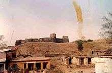
- Kamla Sagar dam is about 6 km south-west of Mauranipur. The river Saprar has been dammed to form the Kamla Sagar reservoir, which covers an area about 10 km2. There is an inspection house and a hill and a ruined fort which is said to have been the residence of the legendary thief Bona, a character of Alha.[12]
- Basneh is on the Mauranipur-Gursarai Road. This place is associated with Bhasmasur, a demon king. Situated at the foot of the Vindhyan hill range, there is a lake and an artificial waterfall. Bhasmasur cave and lush green vegetation which make the place a picnicker's paradise. Inspection house is also available here.[13]
- Gurha is a small village on the left bank of the Dhasau about 15 km south-east of Garantha, 88 km east of Jhansi and 8 km east of Markuan which lies on the road from Garantha to Mauranipur and from here one has to walk to reach the place. The Nagonath hill, a conspicuous landmark, lies a mile north-east of the village and on its crown, there are two old temples and a shrine of Mahadeo in cave and at the foot of the hill on eastern side there is Chandella baithak. There is also an image of sage Vishwamitra, which lies submerged in the Dhasan. A fair is held here in the honour of the saint on the occasion of Makar Sankranti.
History
During 12th century Mauranipur was under Chandella ruler Madanavarman (1129–1163).[14] The credit for the development of Mauranipur goes to the Bundela kings.[15] Mauranipur was one of pargana under Rani Laxmi bai rule. On August 10, 1857 Rani of Tehree occupied Mauranipur. Laxmi Bai suffered reverses in the beginning, but in the war on October 23, with Tehree's forces, she emerged victorious.[16] During 1857 revolt against British Rani Laxmi Bai inflicted defeats on the British at Mauranipur and became the most powerful rebel leader of the 1857 revolt. Her army was further strengthened when the rulers of Banpur and Shahgarh in Bundelkhand became her allies. Fought valiantly against the attacks by British forces under Sir Hugh Rose[17]
Govind Ballabh Pant delivered a speech about the Zamindari Abolition Acts and the establishment of the five-year plan for agriculture in Mauranipur on 30 December 1951.[18]
The town of Mauranipur has long been famous for the manufacture of a red cloth called kharud, which is dyed from a root of the same name. The colour, once fixed by alum, is permanent.
Politics
Mauranipur is a Vidhan Sabha (Legislative Assembly) constituency. This seat is reserved for members of Scheduled Castes.[19]
| Year | Winner Name | Vote% | Party | Runner-Up Candidate | Vote% | Party |
|---|---|---|---|---|---|---|
| 2012 | Rashmi Arya | 29.1 | Samajwadi Party | Rajendra Rahul | 26.25 | Bahujan Samaj Party |
| 2007 | Bhagwati Prasad Sagar | 31.67 | Bahujan Samaj Party | Bihari Lal Arya | 24.32 | Indian National Congress |
| 2002 | Pragi Lal Ahirwar | 24.47 | Bharatiya Janata Party | Bihari Lal Arya | 22.9 | Indian National Congress |
| 1996 | Bihari Lal Arya | 37.69 | Indian National Congress | Pragi Lal Ahirwar | 36.98 | Bharatiya Janata Party |
| 1993 | Bihari Lal Arya | 40.3 | Indian National Congress | Pragi Lal Ahirwar | 35.39 | Bharatiya Janata Party |
| 1991 | Pragi Lal Ahirwar | 39.93 | Bharatiya Janata Party | Bihari Lal Arya | 39.81 | Indian National Congress |
| 1989 | Pragi Lal Ahirwar | 46.55 | Bharatiya Janata Party | Bhagirath Choudhari | 32.72 | Indian National Congress |
| 1985 | Bhagirath Choudhari | 51.35 | Indian National Congress | Prem Narain Ahirwar | 33.11 | Bharatiya Janata Party |
| 1980 | Bhagirath Choudhari | 59.17 | Congress (I) | Har Das | 22.79 | Bharatiya Janata Party |
| 1977 | Prem Narain Ahirwar | 45.09 | Janata Party | Bhagirath Choudhari | 43.88 | Indian National Congress |
Archaeological sites nearby
The following archaeological sites are near Mauranipur:[20]
- Shikhara-roofed temple called Marhia and dedicated to Gond baba - Khojra, Tehsil-Mauranipur
- Remains of a Chandella temple - Kisni Khurd, Tehsil-Mauranipur
- Chandel Temple - Pachwara (Gahras), Tehsil-Mauranipur
- Chandel Temple - Sakarar, Tehsil-Mauranipur
- Old Temple - Rora, Tehsil - Mauranipur
- Kusumadiya, Tehsil-Mauranipur [21]
- Old Fort Bongada, Tehsil-Mauranipur [22]
- Banjaron Ka Mandir, Syavari, Tehsil-Mauranipur [23]
- Shivalaya, Basariya, 15 km from Mauranipur. It was built in the last days of Chandel rule.[24]
- Champat Rai ka Mahal, Kachnev, Near Bangara, Tehsil-Mauranipur [25]
- Maun Sadhana Kendra, Mauranipur
Transport
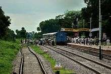
Mauranipur is well connected with three metro city Delhi, Kolkata and Mumbai via Indian Railways network. Mauranipur is 466 km far away from Delhi via Rail and 485 km via Road. Jhansi to Mauranipur railway line came in existence from June 1889 and Mauranipur to Banda railway line came in existence from August 1889. The railway station code of Mauranipur is MRPR. It is connected with other parts of India through National Highway 76. It is 65 km from Jhansi on the way to Khajuraho and 297 km from Lucknow.
Airports
- Jhansi Airport (Bhaskar Maurya )
- Khajurho (Medium Type)
- Gwalior (Medium Type)
Education
The town has been a centre of learning since its early ages. Notable educational institutions from the town include:
Institute
- Software Academy (Computer Education)
Colleges
- Shri Agrasen P. G. College
- Smt Ganeshi Bai Soni Science Degree College
- Shri Ram Dham Maha Vidyalaya
Schools
Intermediate schools
- Sri Laxman Das Damele Inter College
- St. Mary's Inter College
- The Gramodaya International college
- Saraswati Vidhya Mandir
- Deepak Memorial Public girls Inter college_Pooja Chaudhary 2010-14
- Shri R.D. Bundelkhand Vidhya Mandir Inter College
- Gandhi Vidyalaya Inter College
- Nagar Palika Parisad kanya Inter college
- G.G.I.C.
- Pratap InterNational School
High schools
- K.S. Academy
- National Academy_ Hradesh Singh Parihar
- Alma Matter Public School
- Mother Public School
- Sunrise public school
- Futuristic public school
- SVIKS, Khilara
- Kidzee Pre School
- Vision Public School
- P.S. Agrawal Academy Public School
- SMT Devika Devi Dengre Junior High School
- Shri Bade Mahadev Junior High School
- J. B. Mission School, Damele Chowk
- Swami Dayananda P.M. Vidyalaya
- Saraswati Gyan Mandir
- Saraswati Shishu Mandir
- Saraswati Vidya Mandir
- Sahu Samaj Public School\
- Shri Sai Academy, Churara
- Veerangna Laxmibai Vidyamandir, Churara
- Vision public school
References
- ↑ "Falling Rain Genomics - Mauranipur".
- ↑ Edwin Felix T. Atkinson, Statistical, descriptive and historical account of the North-western Provinces of India, Vol. 1 - Bundelkhand (1874), p. 241. Accessed 15 January 2016.
- ↑ Lakheri Dam, 8 March 2015, Online Highways LLC. Accessed 15 Jan. 2015.
- ↑ Records of the Geological Survey of India: Volume 139, Part 8, Geological Survey of India
- ↑ Eastern economist: Volume 75
- ↑ http://censusindia.gov.in/PopulationFinder/Sub_Districts_Master.aspx?state_code=09&district_code=36
- ↑ A-3 Villages By Population, 2011 Census of India, Accessed 15 January 2016.
- ↑ C-1 Population By Religious Community (Uttar Pradesh), 2011 Census of India, Accessed 15 January 2016.
- ↑ http://www.up-tourism.com/ebook/bundelkhand_low.pdf
- ↑ Encyclopaedia of tourism resources in India, Volume 1 By Manohar Sajnani
- ↑ http://www.jainteerth.com/teerth/Todi%20Fatehpur.asp
- ↑ Tourism In India By Vijay Kumar Gupta
- ↑ Tourism In India By Vijay Kumar Gupta
- ↑ A military history of medieval India by Gurcharn Singh Sandhu
- ↑ Population and housing problems in India, Volume 2 by Sahab Deen Maurya
- ↑ Encyclopaedia of Indian Women Through the Ages: Period of freedom struggle By Simmi Jain
- ↑ Imperialism & orientalism: a documentary sourcebook By Barbara Harlow, Mia Carter
- ↑ Selected works of Govind Ballabh Pant, Volume 14 by Govind Ballabh Pant, Bal Ram Nanda
- ↑ Uttar Pradesh district gazetteers, Volume 31
- ↑ http://archaeology.up.nic.in/projection_conservation_3.htm
- ↑ Hindi Daily Amar Ujala
- ↑ Hindi Daily Amar Ujala
- ↑ Hindi Daily Amar Ujala
- ↑ Hindi Daily Amar Ujala
- ↑ Hindi Daily Amar Ujala
-
 This article incorporates text from a publication now in the public domain: Chisholm, Hugh, ed. (1911). "Mau Ranipur". Encyclopædia Britannica (11th ed.). Cambridge University Press.