May 2007 tornado outbreak
 Satellite perspective of the tornadic storms on the evening of May 5, 2007 | |
| Type | Tornado outbreak |
|---|---|
| Duration | May 4–6, 2007 |
| Tornadoes confirmed | 129 confirmed |
| Max rating1 | EF5 tornado |
| Duration of tornado outbreak2 | 56 hours, 9 minutes |
| Damage | $268 million[1] |
| Casualties | 14 deaths, 89 injuries |
| Areas affected | Great Plains, Central United States |
|
1Most severe tornado damage; see Enhanced Fujita scale 2Time from first tornado to last tornado | |
The May 2007 tornado outbreak was an extended tornado outbreak that started on May 4, 2007, affecting portions of the Central United States. The most destructive tornado in the outbreak occurred on the evening of May 4 in western Kansas, where about 95% of the city of Greensburg in Kiowa County was destroyed by an EF5 tornado.[2][3] The supercell killed 13 people, including 11 in Greensburg and two from separate tornadoes.[4][5][6][7] At least 60 people were injured in Greensburg alone. It was the strongest tornado of an outbreak which included several other tornadoes reported across Oklahoma, Colorado, Kansas and South Dakota that occurred on the same night.[8]
Although the most damaging tornado of the outbreak sequence occurred in Greensburg on the 4th, only 25 tornadoes were confirmed that day.[9] That number exploded to 84 the following day (May 5th), with many tornadoes near the affected area from the previous night.[9] Most were in open country, but there were injuries in at least a couple spots in Kansas, and one death reported near a county lake in Ottawa County.[9] 14 more tornadoes were confirmed on May 6 in the region before the outbreak finally ended.[9]
Meteorological synopsis
It is the combination of warm humid air from the Gulf and dry air from the deserts of the Southwest that produce deadly storms.[10] These conditions create an unstable severe storm creating arena.[10] Although tornadoes occur on every continent except Antarctica they are especially common in North America, specifically the United States.[10]
This severe weather outbreak can be traced back to a powerful, slow-moving low pressure area with a warm front to the north over Nebraska and Missouri.[11] On May 4, the low stalled over the High Plains and additional moisture coming from the Gulf of Mexico moved in behind the warm front and increased amounts of instability across much of the region, with CAPE values as high as 5,500 J/kg.[12] In addition, the dry line, which marks a divided line between the dry and humid air mass, was positioned over the southern High Plains. This allowed for the initiation of scattered supercells on May 4. High wind shear also allowed for intense rotation in the atmosphere. All the ingredients were present for the developing of supercell thunderstorms producing damaging wind, large hail and tornadoes.[13]
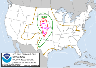
The Storm Prediction Center issued a moderate risk for severe weather across western Kansas and small portions of Oklahoma, Colorado and Nebraska for May 4, while temperatures were in the mid to high 80s°F (near 30 °C). The atmosphere remained capped for much of the day, but storms began to develop in the late afternoon hours in western Oklahoma and the eastern Texas Panhandle.[13] The most intense supercells developed in the early evening hours across northwestern Oklahoma and southwestern Kansas. They eventually produced 25 tornadoes, including the devastating Greensburg tornado and three other extremely large tornadoes which followed the Greensburg tornado late that evening.[14] The supercells remained intact well into the overnight hours as the extremely unstable air mass precluded rapid dissipation expected with the loss of daytime heating which would normally be expected in the Plains. The last tornado of the night did not lift until shortly after 2:00 a.m. early on May 5.[13]
On May 5, the SPC issued a high risk of severe weather for Central Kansas and central Nebraska, while moderate and slight risks for severe weather extended for areas far beyond.[15] The low pressure system in place moved northward, but the extending front had barely moved.[16] The storms were quick to develop. Severe weather reports were already coming in by late morning, and the first tornado reports came in during the early afternoon hours.[17] The most intense activity took place during the late afternoon and evening hours as supercells developed along a long line from South Dakota to North Texas. Over 80 tornadoes were confirmed that day, along with hail as large as softballs and straight–line winds as strong as 90 mph (145 km/h).[17] The activity weakened in the late evening, but not before the last tornadoes were reported in Iowa in the overnight hours.
The low gradually weakened and became less conducive for severe weather development on May 6. Nonetheless, the SPC issued a moderate risk for severe storms over parts of central Kansas and northern Oklahoma as the trough remained in place.[18] The activity was far less than on the two previous days, however there were still several additional tornadoes across the Plains (all of them weak, mostly EF0).[19] The system finally left the area on May 7 and did not produce any more significant severe weather.[20]
Confirmed tornadoes
| EF0 | EF1 | EF2 | EF3 | EF4 | EF5 | Total |
|---|---|---|---|---|---|---|
| 66 | 42 | 15 | 5 | 0 | 1 | 129 |
The Greensburg tornado family
Storm history and damage
| Wikinews has related news: At least nine killed in Greensburg, Kansas tornado |
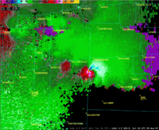
The storm that would produce the EF5 Greensburg tornado began forming after 5:00 pm CDT (2200 UTC) in the northeastern corner of the Texas Panhandle, and went through phases in the early evening across the Oklahoma Panhandle with a few isolated tornadoes.[21] It slowly organized itself as it moved northeast through portions of Oklahoma, and then into Kansas.[12] The first tornado warning with this cell was issued at 8:35 pm CDT (0135 UTC) for Clark County, Kansas,[22] and the tornado first touched down at about 9:00 pm CDT (0200 UTC). Several storm chasers captured the formation of a tornado southwest of Greensburg around 9:20 pm CDT (0220 UTC).[23]
The tornado apparently strengthened as it neared Greensburg and began moving due-north towards the town, and at 9:38 pm CDT (0238 UTC), storm chasers reported that it had grown to over 1/2 mile in diameter. Trees were snapped and oil tanks were destroyed in this rural area, with oil strewn across pastures and roads.[24][25] Several satellite tornadoes were observed as the very large wedge approached the city of Greensburg from the south. At 9:41 pm CDT (0241 UTC) the National Weather Service office in Dodge City issued a Tornado emergency for Greensburg. A tornado emergency is an unofficial product used only for extremely life–threatening situations when a large and likely violent tornado is on the ground and approaching a populated area.[26][27]
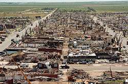
The massive tornado continued north, following Main Street into the south side of Greensburg. Many homes (including an entire row of seven adjacent residences) were swept completely away in this area just south of town, three of which were well-bolted to their foundations. Damage in this area was rated EF5 as a result.[28] The tornado weakened slightly as it entered residential areas in southern Greensburg, but remained violent as numerous homes were destroyed or leveled. Continuing north, downtown Greensburg was completely devastated by the tornado, with numerous businesses destroyed. Two schools, a tractor supply company, the Greensburg City Hall and other businesses fell victim to the violent winds and were destroyed or flattened. A motel on the west side of town was severely damaged, trees throughout the town were completely denuded and debarked, and vehicles were thrown hundreds of feet. The city's water tower was completely toppled and smashed, and the visitor's center at the Big Well (which is the world's largest hand-dug well) was completely destroyed. Train cars were also overturned and hazardous materials teams were called to inspect the wreckage. A tank car was carrying about 14,000 gallons (53,000 liters) of ammonia and the substance started to leak from the tank when workers were starting to lift back the tanker. The courthouse and the grain elevator were spared the worst of the tornado's effects. Meanwhile, the Greensburg meteorite, which was feared to have been blown away, was found and recovered a few days afterwards. Greensburg High School was mostly destroyed by the tornado, sustaining EF4 damage.[28] Numerous homes were swept away across from the high school, four of which were well-bolted to their foundations, warranting an EF5 rating at those residences. The Kiowa County Memorial Hospital was severely damaged at EF3 intensity, and a 4.9-ton reinforced concrete beam was lifted from the structure and thrown onto a nearby vehicle.[28][29][30] Past downtown, neighborhoods in northern Greensburg were flattened before the tornado left the city limits. The tornado continued north of Greensburg, executing a loop in a farm field before dissipating. The total path length was 22 miles (35 km), and the width of the funnel reached 1.7 miles (2.7 km). Overall, 95% of Greensburg was destroyed. A total of 961 homes and businesses were destroyed, 216 received major damage and 307 received minor damage.[31][32]
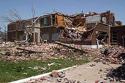
After the main Greensburg tornado dissipated, another large wedge tornado developed north of town. This enormous EF3 tornado rapidly grew to about 2 miles (3.2 km) in diameter as it moved northeast. Near the beginning of the path, two farms were destroyed at high-end EF3 strength, a combine was tossed 1/4 of a mile and smashed to pieces, farm machinery and irrigation pivots were destroyed, along with trees and power lines. The tornado crossed into Edwards County, where additional farms were destroyed, one person was injured, and livestock was killed before the tornado dissipated south of Belpre.[33][34][35] A third large EF3 wedge tornado developed north of Haviland, initially causing minor tree and irrigation pivot damage in Kiowa and Edwards Counties as it moved northeast. In Pratt County, this third tornado grew to over a mile wide, killing one person and injuring another as a farmhouse was swept away. Crossing into Stafford County, the tornado destroyed additional farms, killed livestock, and injured another person. One home in this area was swept completely away, and a vehicle was thrown 3/4 of a mile and mangled beyond recognition. The tornado then weakened and dissipated south of Macksville.[36] Southeast of Macksville, yet another large EF3 wedge tornado developed and moved northeast. A police cruiser was thrown 1/4 of a mile from a road by the tornado and destroyed, killing the officer inside who was watching the previous tornado as it dissipated. Over a dozen farms, trees, pieces of farm machinery, vehicles, irrigation pivots, and power poles were damaged or destroyed by this fourth and final large wedge tornado before it dissipated.[37]
After additional surveys, NWS Dodge City had confirmed 12 tornado tracks by the Greensburg supercell in Kansas alone on May 4, including several weaker and satellite tornadoes that occurred along with the four large wedge tornadoes.[34] The new Enhanced Fujita Scale was implemented on February 1, 2007, and the Greensburg tornado was the first tornado to be rated EF5 on it. Including tornadoes from the older Fujita Scale, the most recent F5 to hit the United States had been on May 3, 1999 during the 1999 Oklahoma tornado outbreak, when a tornado destroyed Bridge Creek and Moore.[34]
This tornado event surpassed the number of fatalities registered on May 4, 2003 during the May 2003 tornado outbreak sequence when eight people were killed by three separate tornadoes that affected areas around Kansas City and points south and west of the city; the last major deadly outbreak registered in Kansas prior to the Greensburg event.[38] It was also the deadliest day and single tornado to hit the state of Kansas since an F5 tornado (which was also the last F5 in that state before this event), hit Wichita and Andover in Sedgwick and Butler counties, killing 17 during the Andover, Kansas Tornado Outbreak on April 26, 1991.[39][40] The Greensburg event was also the deadliest single tornado in the United States since a tornado hit Volusia County in central Florida on February 2, 2007 where 13 were killed in an EF3 tornado. It was also the deadliest day for tornadoes since 20 people were killed in six communities on March 1, 2007.
Aftermath
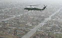
Hours after the tornado hit, Greensburg was judged unsafe and was fully evacuated. Some of the injured were transferred to hospitals in Dodge City and Wichita. The Kansas National Guard was called in to assist in the security measures. Over 100 Red Cross officials were called in while some worked with the Federal Emergency Management Agency for the recovery efforts. Shelters were established at the Haviland High School and Barclay College in nearby Haviland, Kansas and the Oddfellow Lodge in Macksville, Kansas.[41] After the tornado, looting was reported in the community and at least seven suspects, including four soldiers that were not part of the relief effort and went to Greensburg on their own, were arrested and faced charges of burglary and theft.[42][43] A dusk-to-dawn curfew was put in place in the community after the tornado hit.[44]
The American Red Cross maintained a list of "Safe and Well" families at their website disastersafe.redcross.org. [45] Meanwhile, officials also set a shelter for lost and injured animals as they reported to had found 163 animals alive in Greensburg after the tornado.[46] Kansas Governor Kathleen Sebelius and President George W. Bush both declared Kiowa County a disaster area.[47]
Total damage from the outbreak was estimated at about $268 million,[1] and insured damage from the Greensburg tornado alone was estimated at $153 million.[48]
Non-tornadic events
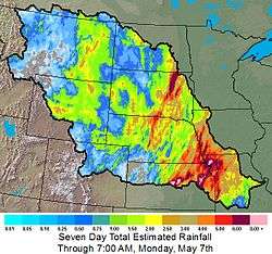
In addition to the tornadoes, widespread flooding occurred across central North America as a result of the same system producing continuous thunderstorms. There were two major reasons for the flooding: The storm system itself moved very slowly, having produced significant tornado outbreaks in almost the same places for three days. In addition, the storms moved along each other's paths, so one storm dropped heavy rains on the same place that the storm before it did (this is also known as "training").

Across portions of eastern Nebraska and western Iowa, rainfall amounts exceeded locally 6 inches (152 mm).[49] In northeastern and central Kansas, rainfall amounts approached 5 – 6 inches locally (125 – 150 mm).[50][51] In North Dakota,[52] southern Manitoba and southern Saskatchewan, heavy rainfalls of 1 – 3 inches (25 – 75 mm) fell from this system from May 4 to May 7.[53] Similar amounts were reported in Alberta on May 3 and May 4.[54]
Some of the worst flooding affected Topeka, Kansas, where several rescues had to be made, and the Kansas City Metro Area, where several roads were closed. In neighboring Missouri, levees broke along the Missouri River which caused extensive flooding to hundreds of homes and the northwest and central part of the state. The National Guard were assisting on filling sandbags to protect homes, schools and plants across the state which experienced some of the worst flooding since the Great Flood of 1993 which affected most of the Mississippi River Valley. Torrential rains on May 10 had also caused flooding in parts of southern Missouri as well as in eastern Kansas.[55][56] The heavy rains also affected activities surrounding the Riverfest (Wichita River Festival) which postponed some events until May 14.[57] The Arkansas River reached record levels near Haven when it crested at 13.08 feet on May 8. Some flooding into low-lying areas was also observed in the Wichita Metropolitan Area. Rainfall amounts in southern and southeastern Kansas also exceeded 6 inches (152 mm) over a two-day period on May 6 and May 7. There were several reports of farmers who lost several cattle who have been toss by the high water levels.[58]
In Aberdeen, South Dakota, 7.75 inches (197 mm) of rain fell the evening of May 5 into the early morning hours of May 6, causing significant flooding in some areas around the city. It was also the city's new 24‑hour record rainfall, breaking the old mark of 5.20 inches (132 mm) set in June 1978.[59] The highest unofficial rainfall total was reported in Epiphany, South Dakota where as much as 10 inches (254 mm) fell during the weekend.[60] The highest official report of rain, 8.73 inches (222 mm) at Columbia, South Dakota, set a new official 24–hour May rainfall record for the entire state of South Dakota.[61]
In southern Oklahoma City and surrounding communities, strong straightline winds caused damage to several buildings and downed trees and power lines in the early morning hours of May 7, with cleanup efforts being complicated due to flooding rains accompanying the storm. About 11,000 homes were without power during the event.[62] There were also reports of floods across many other areas in Oklahoma. Oklahoma Governor Brad Henry had declared a state of emergency for all 77 counties across the state due to all the severe weather including the tornadoes, the flash floods and hail.[63]
Snow was also reported across higher elevations in Colorado, Wyoming, Nebraska and Utah with local amounts of up to one foot (30 cm) across central Colorado.[64]
See also
- List of F5 and EF5 tornadoes
- List of North American tornadoes and tornado outbreaks
- Tornadoes of 2007
- Tornado Emergency
References
- 1 2 National Climatic Data Center. "NCDC Storm Events-Select State". Storm Events Database. National Oceanic and Atmospheric Administration. Retrieved 2010-03-02.
- ↑ "At Least 10 Dead After Supercell Tornado Demolishes Kansas Town". FoxNews.com. May 5, 2007. Retrieved 2007-05-05.
- ↑ KAKE-TV. "Greensburg Tornado Rated at EF-5". Retrieved 2007-05-06.
- ↑ KAKE-TV. "Police Officer Injured In Tornado Dies". Retrieved 2007-05-09.
- ↑ "Death toll rises to nine after tornado destroys Kansas town". The Clarion-Ledger. Retrieved 2007-05-06.
- ↑ "Deadly twister flattens Kansas town". CNN. Archived from the original on May 10, 2007. Retrieved 2007-05-05.
- ↑ CNN, Storm-hit Kansas residents return home 6:30 am EDT, May 8, 2007, retrieved 7:50 am EDT, May 8, 2007.
- ↑ "SPC Storm Reports for 5/4/07". Storm Prediction Center. May 4, 2007. Retrieved 2007-05-05.
- 1 2 3 4 "One Year after Tornado, Greensburg Still Struggling to Survive". Insurance Journal. Retrieved 2016-04-02.
- 1 2 3 "How Kansas Tornado Became a Monster". news.nationalgeographic.com. Retrieved 2016-04-02.
- ↑ US Department of Commerce. "Daily Weather Maps, Saturday May 5, 2007". Retrieved 2007-05-14.
- 1 2 Davies, Jon. "CAPE/CIN (J/Kg, Saturday May 5, 2007)". Archived from the original on June 5, 2007. Retrieved 2007-05-14.
- 1 2 3 Davies, Jon. "The Greensburg Tornado Environment on 4 May 2007". Archived from the original on May 16, 2007. Retrieved 2007-05-14.
- ↑ NOAA, National Weather Service. "Tornado Watch 227". Retrieved 2007-05-14.
- ↑ Storm Prediction Center. "May 5, 2007 1300 UTC Day 1 Convective Outlook". Retrieved 2007-05-14.
- ↑ US Department of Commerce. "Daily Weather Maps, Sunday May 6, 2007". Retrieved 2007-05-14.
- 1 2 "SPC Storm Reports for 5/5/07". Storm Prediction Center. May 5, 2007. Retrieved 2007-05-05.
- ↑ Storm Prediction Center. "May 6, 2007 1300 UTC Day 1 Convective Outlook". Retrieved 2007-05-14.
- ↑ "SPC Storm Reports for 5/6/07". Storm Prediction Center. May 6, 2007. Retrieved 2007-05-07.
- ↑ "SPC Storm Reports for 5/7/07". Storm Prediction Center. May 7, 2007. Retrieved 2007-05-08.
- ↑ National Climatic Data Center. "Event Record Details: (04/1721)". National Weather Service. Retrieved 2008-02-29.
- ↑ "KDDC [050139] - Tornado Warning". Archived from the original on July 15, 2014. Retrieved 2008-02-29.
- ↑ "KDDC [050220] - Tornado Warning". Retrieved 2008-02-29.
- ↑ http://www.ncdc.noaa.gov/stormevents/eventdetails.jsp?id=35934
- ↑ Robb Lawson. "Barton and Ellsworth County Tornado". National Weather Service. Retrieved 2007-05-05.
- ↑ Herb White. "Aware: Climate, Water, Weather" (PDF). National Weather Service. Archived from the original (PDF) on 2008-04-11. Retrieved 2008-02-29.
- ↑ CNN. "Survivors sought as more storms threaten Plains". Archived from the original on May 9, 2007. Retrieved 2007-05-06.
- 1 2 3 Marshall, Tim (2007). "Damage Survey of the Greensburg, KS tornado" (PDF). ams.confex.com. American Meteorological Society. Retrieved July 9, 2014.
- ↑ McCarthy, Daniel (2007). "The Greensburg, KS Tornado" (PDF). ams.confex.com. American Meteorological Society. Retrieved July 9, 2014.
- ↑ KAKE-TV. "Greensburg Meteorite Recovered". Retrieved 2007-05-09.
- ↑ http://www.ncdc.noaa.gov/stormevents/eventdetails.jsp?id=35937
- ↑ "Search Resumes in Devastated Kansas Town". Archived from the original on 2007-05-10. Retrieved 2007-05-05.
- ↑ http://www.ncdc.noaa.gov/stormevents/eventdetails.jsp?id=35996
- 1 2 3 NWS Dodge City. "Greensburg Tornado Rated EF-5 (updated May 22)". Retrieved 2007-05-22.
- ↑ National Climatic Data Center. "NCDC Storm Reports". National Weather Service. Retrieved 2008-02-29.
- ↑ http://www.ncdc.noaa.gov/stormevents/eventdetails.jsp?id=36002
- ↑ http://www.ncdc.noaa.gov/stormevents/eventdetails.jsp?id=36003
- ↑ "Tornadoes of the Past". The Tornado Project. 2003. Retrieved 2007-05-05.
- ↑ "Sedgwick County Tornado Details". National Climatic Data Center. April 26, 1991. Retrieved 2007-05-05.
- ↑ "Butler County Tornado Details". National Climatic Data Center. April 26, 1991. Retrieved 2007-05-05.
- ↑ "Greensburg Suffers Significant Damage In Tornado". Retrieved 2007-05-04.
- ↑ KAKE-TV. "Soldiers Accused of Looting in Court". Retrieved 2007-05-10.
- ↑ CNN.com. "Looting suspects arrested in storm-ravaged Kansas town". Archived from the original on May 17, 2007. Retrieved 2007-05-08.
- ↑ Probst, Jason (May 7, 2007). "Officials to tour area today; dusk-to-dawn curfew in place". The Hutchinson News.
- ↑ "Red Cross Safe and Well Website". Retrieved 2007-05-04.
- ↑ KAKE-TV. "Animals Are Tornado Victims Too". Retrieved 2007-05-09.
- ↑ KAKE-TV. "President Bush Declares Disaster in Kansas". Retrieved 2007-05-06.
- ↑ Kansas.com | 06/21/2007 | Insured losses from twister: $153 million
- ↑ NWS Omaha, Nebraska. "24 Hour Rainfall Reports Received the Morning of Sunday May 6th, 2007". Archived from the original on June 20, 2007. Retrieved 2007-05-07.
- ↑ NWS Topeka, Kansas. "24 hour precipitation ending around 7 AM May 6, 2007". Retrieved 2007-05-07.
- ↑ NWS Wichita, Kansas. "Weekend of Severe Weather For Central Kansas!". Retrieved 2007-05-07.
- ↑ NWS Bismarck, North Dakota. "Precipitation Totals - May 4–7, 2007". Retrieved 2007-05-07.
- ↑ "Public Weather Warnings for Canada". Environment Canada. May 5, 2007. Retrieved 2007-05-05.
- ↑ "Special Weather Statements for Alberta". Environment Canada. May 5, 2007. Retrieved 2007-05-05.
- ↑ CNN.com. "Missouri flooding keeps sandbaggers busy". Archived from the original on May 18, 2007. Retrieved 2007-05-11.
- ↑ NWS St. Louis. "MODERATE TO MAJOR FLOODING EXPECTED ON THE MISSOURI RIVER". Retrieved 2007-05-08.
- ↑ KAKE-TV. "Riverfest Deals With Rising Water". Retrieved 2007-05-11.
- ↑ NWS Wichita. "Record and near Record Flooding the 2nd week of May". Retrieved 2007-05-14.
- ↑ NWS Aberdeen, South Dakota. "Record Rainfall". Retrieved 2007-05-07.
- ↑ NWS Sioux Falls, South Dakota. "Storm Total Rainfall Reports for the Weekend". Retrieved 2007-05-07.
- ↑ McGahee, Alvin (June 1, 2007). "Selected U.S. City and State Extremes May 2007". NCDC. Retrieved 2008-02-05.
- ↑ Newsok.com. "Rain causes flooding; bridge collapse; power outages".
- ↑ KOCO-TV. "State Of Emergency Declared For All 77 Counties". Retrieved 2007-05-08.
- ↑ NWS Denver, Colorado. "NE Colorado Snow Event Recap May 5–7, 2007". Retrieved 2007-05-07.
External links
- High resolution Photograph of Greensburg, KS Wedge Tornado Under The Parent Supercell At The Time It Was Damaging Greensburg.
- Videos and discussions of recent Midwest Tornado
- Preliminary synopsis of tornadoes in Barton and Rice County (from the same supercell that formed the Greensburg tornado) (courtesy of NWS Wichita, Kansas)
- Aerial photos of Greensburg, KS after the tornado
- Additional Tornado damage and storm event photos (courtesy of KAKE-TV, Wichita)
- NWS Dodge City, Kansas Greensburg Tornado Page
- TORNADOES, HEAVY RAIN HAMMER CENTRAL PLAINS, MORE STORMS EXPECTED
- Greensburg area tornadoes summary (courtesy of NWS Dodge City, Kansas - last update: May 22, 2007)
- Weather Synopsis of May 5, 2007 Outbreak in Oklahoma (NWS Norman, Oklahoma)
Coordinates: 37°36′16″N 99°17′37″W / 37.604316°N 99.293488°W