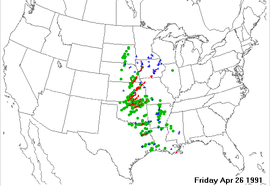
April 26, 1991 tornado outbreak
Coordinates: 37°41′24″N 97°08′10″W / 37.69°N 97.136°W
 Storm reports from April 26, 1991 | |
| Type | Tornado outbreak |
|---|---|
| Duration | April 26, 1991 |
| Tornadoes confirmed | 55 confirmed |
| Max rating1 | F5 tornado |
| Duration of tornado outbreak2 | 19 hours |
| Highest winds |
|
| Damage | 250+ million (1991 USD) [1] |
| Casualties | 21 fatalities, hundreds of injuries |
| Areas affected | United States Great Plains |
|
1Most severe tornado damage; see Fujita scale 2Time from first tornado to last tornado | |
The April 26, 1991 tornado outbreak was a violent outbreak of 55 tornadoes that took place on April 26, 1991 in the Central and Southern Great Plains, killing 21 people and injuring hundreds more.
Meteorological synopsis
On April 25, 1991, the National Severe Storms Forecast Center, now called the Storm Prediction Center, forecast a high risk of severe weather for the following day.[2] A strong storm system was due to move through the area the next afternoon and evening of April 26, 1991.
Confirmed tornadoes
| F0 | F1 | F2 | F3 | F4 | F5 | Total |
|---|---|---|---|---|---|---|
| 12 | 13 | 18 | 7 | 4 | 1 | 55 |
(based on NOAA Storm Data)
| F# | Location | County | Time (UTC) | Path length | Damage | |
|---|---|---|---|---|---|---|
| Oklahoma | ||||||
| F2 | Tonkawa area | Kay | 0545 | 1 mile (1.6 km) |
||
| F3 | E of Enid | Garfield | 1700 | 6 miles (9.7 km) |
Two homes were destroyed. | |
| F0 | W of Garber | Garfield | 1715 | 0.1 miles (0.16 km) |
||
| F4 | E of Garber to NW of Pawhuska | Garfield, Noble, Osage | 1730 | 66 miles (107.0 km) |
- See section on this tornado | |
| F2 | SW of Yale | Payne | 1838 | 7 miles (11.3 km) |
A dump truck was rolled 200 yards and a well-built barn was destroyed. Two homes lost their roofs as well. | |
| F4 | SW of Terlton to SW of Skiatook | Pawnee, Osage | 1910 | 32 miles (51.9 km) |
1 death - Tornado began near Terlton, inflicting minor to moderate damage to trees, power poles, and a few structures. The tornado then rapidly intensified into a violent wedge, sweeping several cars off of the Cimarron Turnpike, resulting in a fatality. The tornado then struck the Keystone Airpark, destroying four hangars and seven airplanes. Two of the planes were tossed into trees. The fire station at the airport was completely destroyed, with one fire engine tossed a quarter mile into trees across the runway. The tornado then struck Westport, destroying 54 homes and damaging 40 others. 70 vehicles, five mobile homes, 18 outbuildings, and three travel trailers were destroyed as well. The Westport community center was also damaged. The tornado then snapped numerous trees and destroyed a Girl Scouts lodge near Lake Keystone before causing additional severe damage in the Skiatook area. Several boats and a marina were damaged at Skiatook Lake, and one 3,000 pound sailboat was thrown half a mile. A nearby propane company was damaged as well. 32 homes were destroyed and 56 others were damaged in the Skiatook area before the tornado dissipated. 24 people were injured.[3][4] | |
| F1 | E of Little Chief | Osage | 1927 | 0.3 miles (0.5 km) |
||
| F2 | E of Copan | Washington | 2005 | 6 miles (9.7 km) |
1 death - Tornado destroyed a convenience store and caused $100,000 in damage. Fatality occurred when a car was tossed 250 yards into a field. 10 people were injured. | |
| F4 | Oologah area | Rogers | 2045 | 4 miles (6.5 km) |
Though short-lived, this large and violent tornado devastated the town of Oologah before abruptly dissipating. 60 homes, 16 trailers, 30 barns, and 16 apartment buildings were destroyed. Some of the homes were swept away. The Oolagah School building was severely damaged, and multiple school buses were thrown half a mile into Four-Mile Creek. Several metal high-tension towers were downed, and a gas station was destroyed as well. 22 people were injured; however, there were no fatalities. Caused $15,000,000 in damage. On top of the destruction this tornado caused, a downburst that followed the storm caused further damage.[4][5] | |
| F1 | Chelsea area | Rogers | 2110 | 2 miles (3.2 km) |
||
| Kansas | ||||||
| F2 | N of Cherryvale | Montgomery | 0945 | 6 miles (9.7 km) |
A large building at a nursery/greenhouse complex was destroyed, with a loss of $250,000. | |
| F2 | NW of Washington | Washington | 1425 | 4 miles (6.5 km) |
Several farm houses were destroyed, and some damage occurred in the town of Ladham. Six people were injured. Rated F3 by Grazulis. | |
| F0 | N of Strong City | Chase | 1445 | 1 mile (1.6 km) |
||
| F3 | NW of Hanover to S of Beatrice, NE | Washington, KS, Gage, NE | 1450 | 25 miles (40.5 km) |
Tornado first touched down in Kansas before moving into Nebraska, where the town of Lanham sustained considerable damage. Farms sustained heavy damage near Oden, and several homes were destroyed south of Beatrice before the tornado dissipated. | |
| F0 | NE of Council Grove | Morris, Wabaunsee | 1510 | 13 miles (21.1 km) |
||
| F2 | N of Bushong to NE of Grove | Wabaunsee, Shawnee, Jackson | 1535 | 44 miles (71.3 km) |
In Waubaunsee County, a farmhouse was destroyed before the tornado moved into Shawnee County and passed near Grove. The tornado produced F0 to F1 damage in Jackson county before dissipating. | |
| F0 | SW of Danville | Harper | 1620 | 1 miles (1.6 km) |
||
| F0 | SE of Freeport to NE of Argonia | Sumner | 1630 | 16 miles (25.6 km) |
||
| F1 | N of Goddard | Sedgwick | 1647 | 2 miles (3.2 km) |
||
| F5 | SW of Haysville to N of El Dorado | Sedgwick, Butler | 1657 | 46 miles (74.6 km) |
17 deaths - See section on this tornado | |
| F1 | S of Putnam | Sedgwick, Harvey | 1710 | 16 miles (25.6 km) |
||
| F4 | W of Arkansas City to NW of Cambridge | Cowley | 1730 | 25 miles (40.5 km) |
1 death - Large wedge tornado passed Arkansas City to the west, and then passed west of Hackney, leveling several homes south of town. A woman was killed in her trailer near Tisdale. Caused $5,000,000 in damage. | |
| F0 | W of McFarland | Wabaunsee | 1735 | 9 miles (14.6 km) |
||
| F2 | NE of El Dorado to E of Matfield Green | Butler, Chase | 1810 | 21 miles (33.6 km) |
See section on this tornado | |
| F3 | W of Howard to Severy | Elk, Greenwood | 1826 | 14 miles (22.7 km) |
1 death - Spawned from the same storm that produced the Hackney F4 tornado. A house was severely damaged near the beginning of the path, and a mobile home was flattened elsewhere, resulting in a fatality. Two others were injured. Rated F2 by Grazulis. | |
| F0 | W of Strong City | Chase | 1840 | 1 mile (1.6 km) |
||
| F0 | S of Wichita | Sedgwick | 1933 | 1 mile (1.6 km) |
||
| F3 | SW of Toronto to SE of Virgil | Greenwood, Woodson | 1935 | 15 miles (24.3 km) |
Homes and other buildings were destroyed and 26 power poles were snapped. Equipment at a rock quarry was severely damaged, and a 35,000 pound fuel truck was moved 75 yards. A farmhouse was lifted, rotated 90 degrees, and set back down. | |
| F1 | S of Meriden | Shawnee, Jefferson | 1954 | 11 miles (17.8 km) |
||
| F2 | NE of Valley Falls to SW of Doniphan | Jefferson, Atchison | 2025 | 25 miles (40.5 km) |
Tornado caused severe damage in the Nortonville area, with 13 homes destroyed. A nursing home and several businesses sustained major damage as well. In Atchison County, a grain elevator was damaged and outbuildings were destroyed. | |
| F0 | W of Coffeyville | Montgomery | 2120 | 1 miles (1.6 km) |
||
| Nebraska | ||||||
| F1 | N of Ohiowa | Fillmore | 1440 | 1 mile (1.6 km) |
||
| F2 | E of Adams | Gage | 1600 | 4 miles (6.5 km) |
Farms were damaged. | |
| F3 | E of Palmyra | Otoe | 1615 | 14 miles (22.7 km) |
Four farms were destroyed and three homes were damaged. Two people were injured. | |
| F0 | SW of Plainview | Pierce | 1715 | 0.1 miles (0.16 km) |
||
| Texas | ||||||
| F2 | E of Reese | Cherokee | 1800 | unknown | Two trailers and four homes were destroyed. | |
| F3 | S of Mount Selman | Cherokee | 1811 | 3 miles (4.9 km) |
Three trailers, two frame homes, and one vehicle were destroyed. 25 other homes were damaged. | |
| F2 | S of Wright City | Smith, Rusk | 1840 | 3 miles (4.8 km) |
Trees were uprooted. Rated F1 by Grazulis. | |
| F2 | W of Henderson | Rusk | 1900 | unknown | A barn and outbuildings were destroyed. | |
| F1 | Henderson area | Rusk | 1922 | unknown | ||
| F2 | S of Detroit | Red River | 2100 | unknown | Two homes and a barn were destroyed. | |
| F1 | NW of Bagwell | Red River | 2119 | unknown | ||
| F2 | S of Negley | Red River | 2130 | unknown | A barn was destroyed, a mobile home was overturned, and homes were damaged. | |
| F1 | N of Detroit | Red River | 0105 | unknown | ||
| Iowa | ||||||
| F1 | NW of Westphalia | Shelby | 1844 | 2 miles (3.2 km) |
||
| F3 | Denison area | Crawford, Sac | 1900 | 7.7 miles (12.3 km) |
Inflicted $1,000,000 in damage to farms. | |
| F2 | Milford area | Dickinson | 2000 | 18 miles (29.3 km) |
Two farms were damaged. Rated F1 by Grazulis. | |
| F2 | Allerton area | Wayne | 2210 | 9 miles (14.6 km) |
This and the following tornado damaged about 25 properties. | |
| F2 | S of Sewa to SE of Confidence | Wayne | 2210 | 15 miles (24.3 km) |
Paralleled the previous tornado. Two people were injured when mobile homes were destroyed near Harvard. | |
| F2 | SE of Victor | Iowa | 0055 | 5 miles (8.1 km) |
A farmhouse was damaged. Rated F1 by Grazulis. | |
| F1 | S of Marengo | Iowa | 0109 | 2 miles (3.2 km) |
||
| Missouri | ||||||
| F1 | NE of Rochester | Andrew | 2115 | 2 miles (3.2 km) |
||
| F0 | S of Joplin | Newton | 2239 | 3 miles (4.9 km) |
||
| F1 | N of Cosby | Andrew | 2257 | 2 miles (3.2 km) |
||
| F0 | W of Joplin | Jasper | 2305 | unknown | ||
| Sources: NOAA Storm Data, Tornado History Project - Storm Data for April 26, 1991 | ||||||
Notable tornadoes
Haysville–McConnell AFB–Andover, Kansas
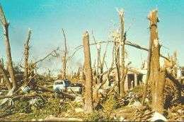
This long-tracked tornado reached a powerful F5 status and was the most destructive tornado of the entire outbreak. It is considered one of the most-filmed F5 tornadoes of all time, because by 1991, video camcorders were very popular and easily obtainable by the general public. The Andover tornado was filmed from many different angles throughout its life.
It first produced extensive damage as it formed south of Clearwater, Kansas. It fluctuated in intensity near the beginning of the path, and then moved through the north side of the city of Haysville, near 63rd Street South and Meridian. Widespread damage was reported in Haysville with many structures destroyed, but there were no fatalities. The tornado entered Wichita city limits near 56th Street South and Broadway/US-81, crossed the Kansas Turnpike at the overpass over 55th Street South. The tornado expanded to around 300 feet wide as it crossed I-35 (the Kansas Turnpike), destroyed a plant nursery at 53rd Street South and Hydraulic Street, and headed toward McConnell Air Force Base. Many people had advance warning before the tornado struck McConnell AFB. The tornado struck the base school, hospital and housing as an F3 tornado. It caused $62 million in damage on the base, narrowly missing a multibillion-dollar line of B-1 bombers. The damage path widened dramatically as the tornado intensified just east-northeast of the base.[6][7]
By 6:35 p.m., the tornado had expanded to just over 600 yards wide and was approaching maximum intensity. It continued to move northeast exiting the Wichita metro area and reached F5 intensity as it tore through the town of Andover, Kansas. Thirteen people were killed as the Golden Spur Mobile Home Park was obliterated, with little left there but scattered debris and twisted mobile home frames. The death toll included a father and son who abandoned their car and sought shelter in a ditch nearby. Extensive wind-rowing of debris and grass scouring was noted as the tornado swept large, well-constructed homes cleanly from their foundations just west of N Andover Road as the tornado passed through densely populated residential areas. Vehicles were thrown nearly a mile from where they originated, and trees in the area were completely debarked. One vehicle that originated at the Golden Spur mobile home park was thrown 3/4 of a mile, and was so thoroughly mangled that surveyors could not determine if it was a car or a truck.[7] The tornado then veered north, missing a Girl Scout camp where summer camp training was being conducted and a troop campout. The tornado then moved on to the northeast, passing just south of Towanda. The damage in this area was rated at F4 intensity as additional well-built homes were leveled. The tornado continued northeast and reached El Dorado Lake just before 7pm (CST). Video taken by local storm chasers shows that the tornado crossed over the lake and revealed a multiple vortex structure. Just after crossing over the lake to the northeast, the circulation dissipated and died out. The Andover tornado had traveled for nearly 46 miles, and was on the ground for over an hour.[6][7]
This was the last F5 tornado recorded in Kansas under the old Fujita scale. The next tornado of such intensity, an EF5 on the newer Enhanced Fujita scale, wouldn't be reported until 16 years later on May 4, 2007, in Greensburg, Kiowa County, about 120 miles west of the path of the 1991 tornado. Since February 1, 2007, the National Weather Service has used the Enhanced Fujita scale.
El Dorado Lake/Kansas Turnpike Underpass, Kansas
| State | Total | County | County total |
|---|---|---|---|
| Kansas | 19 | Butler | 13 |
| Cowley | 1 | ||
| Elk | 1 | ||
| Sedgwick | 4 | ||
| Oklahoma | 2 | Pawnee | 1 |
| Washington | 1 | ||
| Totals | 21 | ||
| All deaths were tornado-related | |||
The new tornado moved northeast from the edge of El Dorado Lake toward Cassoday. A news team from KSNW-TV in Wichita was returning to the station along the Kansas Turnpike from a story unrelated to the tornado. Reporters Ted Lewis and Greg Jarrett soon encountered a tornado, and decided to try to shoot video of the storm. However, the tornado veered and began following the crew along the highway at a speed faster than they could drive. They reached an overpass where several people had already abandoned their cars. The cameraman advised the other people that they should all get into the very upper part of the overpass, thinking that this would shield them from the wind. The cameraman recorded the entire chain of events as the tornado passed nearby, tossing the van and throwing debris. The overpass itself did not receive a direct hit from the tornado, but it appeared to on camera as the tornado passed just behind the cameraman's location. It lasted approximately 20 seconds. The tornado then continued northeast and dissipated at about 7:30 p.m., just northeast of the Cassoday Interchange of the Kansas Turnpike. All the cars parked under the underpass had their windows blown out. Other cars and tractor-trailers on the turnpike (hit by the tornado) rolled multiple times or were tossed from the roadway, injuring four people.
Due to the popularity of the news team's video, in which they are depicted surviving by using an overpass for shelter, overpasses are now frequently jammed with people seeking shelter during tornado activity. Such was the case in many areas during the 1999 Oklahoma tornado outbreak, in which some people left the safety of their homes when the tornado warning was issued to take shelter under overpasses. One tornado hit three underpasses and killed people at each one. It is now believed that highway overpasses provide little, if any, protection from tornadic winds, and the National Weather Service strongly advises against using overpasses for shelter. An overpass is an extremely dangerous spot to be in a tornado, especially if it does not have the open girder design like that in the video. Using underpasses as protection does little more than raise people above ground level, exposing them to higher winds and more debris. Additionally, the wind speed may be increased by the wind tunnel effect.[8] Another danger is the sheer number of people now congregating at underpasses blocks traffic, which has hindered emergency responders. Moreover, it presents the danger that an intense tornado will hit people taking shelter as well as bystanders stuck in traffic, who are massed in a vulnerable location incurring the possibility of a significant death toll.[9]
Red Rock, Oklahoma
South of Wichita, in Garfield County, Oklahoma, tornado chasers (including Warren Faidley, Gene Moore, Howard Bluestein, KJRH-TV meteorologist Gary Shore and many other chasers) observed the touchdown of what would be the longest-tracked tornado of the outbreak. The tornado began 2.5 miles east of Garber, and then grew into a large 3/4 mile wide wedge as it passed south of Billings, destroying a house. As the tornado passed near Ceres, two farms were destroyed. In rural areas of Noble County, trees were debarked and pavement was scoured off of several county roads. The tornado then crossed into Osage County, uprooting trees and damaging another house as it passed near Fairfax. At least one home was completely demolished, leaving no walls standing (indicating F4 damage). At one point, a University of Oklahoma chase team used a portable Doppler weather radar to measure a wind speed of up to 268 mph in the funnel, indicating that winds reached F5 intensity within the tornado. However, these readings were taken near the top of the funnel, indicating that these winds may not have reached ground level. At the time, this was the fastest wind speed ever measured on Earth (it has now been surpassed by a tornado near Bridge Creek in Central Oklahoma on May 3, 1999, which produced a 1/4 mile gust of 301 mph[10]). A large oil rig was toppled before the tornado lifted in central Osage County, after having traveled for 66 miles and injuring six people. It encountered few man-made structures along its path, making it difficult for storm survey teams to rate. It was given an F4 rating.[7]
Aftermath
The 1991 outbreak was featured in two different documentaries: the first one was Enemy Wind, a documentary produced by The Weather Channel. It was also covered in Cyclone, a documentary that was produced and distributed by National Geographic, which released this one and dozens of other documentaries under its National Geographic Home Video series, and were released in both VHS and DVD formats.
See also
- List of North American tornadoes and tornado outbreaks
- List of Storm Prediction Center high risk days
References
- ↑ "Tornado Disaster - Kansas, 1991". Cdc.gov. Retrieved 2010-09-07.
- ↑
- ↑ "Newspaper Accounts". NWS Tulsa. NWS Tulsa. Retrieved 9 December 2013.
- 1 2 "Violent Tornadoes (F4/EF4/F5/EF5) in Oklahoma (1950-Present)". NWS Norman. NWS Norman. September 16, 2013. Retrieved 9 December 2013.
- ↑ "Rebuilding the Oolagah School". NWS Tulsa. NWS Tulsa. Retrieved 9 December 2013.
- 1 2 "The Plains tornado outbreak of April 26, 1991". NWS Tulsa. NWS Tulsa. Retrieved 9 December 2013.
- 1 2 3 4 Thomas P. Grazulis (July 1993). Significant Tornadoes 1680-1991. St. Johnsbury, Vermont: The Tornado Project of Environmental Films. ISBN 1-879362-03-1.
- ↑ Speed Up Effects: Tunnel Effects, Danish Wind Industry Association Archived June 10, 2008, at the Wayback Machine.
- ↑ NWS Presentation on Deaths Due to Use of Underpasses as Shelters Archived August 25, 2009, at the Wayback Machine.
- ↑ Doppler On Wheels - Center for Severe Weather Research (cswr.org) Archived September 7, 2010, at WebCite
External links
- Map of The Andover, Kansas Outbreak Tornado History Project
- Gene Moore's April 26, 1991 Chase Account
- NOAA Storm Data
- ^ Site dispelling tornado "myths," with a mention of overpasses