McAdoo Township, Barber County, Kansas
| McAdoo Township | |
|---|---|
| Township | |
 Location in Barber County | |
| Coordinates: 37°25′40″N 098°48′41″W / 37.42778°N 98.81139°WCoordinates: 37°25′40″N 098°48′41″W / 37.42778°N 98.81139°W | |
| Country | United States |
| State | Kansas |
| County | Barber |
| Area | |
| • Total | 35.97 sq mi (93.17 km2) |
| • Land | 35.84 sq mi (92.83 km2) |
| • Water | 0.13 sq mi (0.33 km2) 0.35% |
| Elevation | 1,877 ft (572 m) |
| Population (2000) | |
| • Total | 29 |
| • Density | 0.8/sq mi (0.3/km2) |
| GNIS feature ID | 0470372 |
McAdoo Township is a township in Barber County, Kansas, USA. As of the 2000 census, its population was 29.
History
McAdoo Township was named for the McAdoo family of pioneer settlers.[1]
Geography
McAdoo Township covers an area of 35.97 square miles (93.2 km2) and contains no incorporated settlements.
The streams of East Branch South Elm Creek and West Branch South Elm Creek run through this township.
Notes
- ↑ A Biographical History of Central Kansas. Lewis Publishing Company. 1902. p. 869.
References
External links
Municipalities and communities of Barber County, Kansas, United States | ||
|---|---|---|
| Cities | 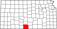 | |
| Unincorporated communities | ||
| Townships | ||
This article is issued from Wikipedia - version of the 10/4/2016. The text is available under the Creative Commons Attribution/Share Alike but additional terms may apply for the media files.