Mingona Township, Barber County, Kansas
| Mingona Township | |
|---|---|
| Township | |
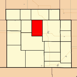 Location in Barber County | |
| Coordinates: 37°19′00″N 098°42′01″W / 37.31667°N 98.70028°WCoordinates: 37°19′00″N 098°42′01″W / 37.31667°N 98.70028°W | |
| Country | United States |
| State | Kansas |
| County | Barber |
| Area | |
| • Total | 53.56 sq mi (138.71 km2) |
| • Land | 53.5 sq mi (138.57 km2) |
| • Water | 0.06 sq mi (0.14 km2) 0.1% |
| Elevation | 1,526 ft (465 m) |
| Population (2000) | |
| • Total | 57 |
| • Density | 1.1/sq mi (0.4/km2) |
| GNIS feature ID | 0470439 |
Mingona Township is a township in Barber County, Kansas, USA. As of the 2000 census, its population was 57.
Geography
Mingona Township covers an area of 53.56 square miles (138.7 km2) and contains no incorporated settlements.
The stream of Bitter Creek runs through this township.
References
External links
Municipalities and communities of Barber County, Kansas, United States | ||
|---|---|---|
| Cities | 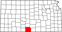 | |
| Unincorporated communities | ||
| Townships | ||
This article is issued from Wikipedia - version of the 11/11/2013. The text is available under the Creative Commons Attribution/Share Alike but additional terms may apply for the media files.