Kiowa, Kansas
| Kiowa, Kansas | |
|---|---|
| City | |
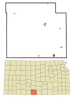 Location within Barber County and Kansas | |
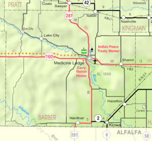 KDOT map of Barber County (legend) | |
| Coordinates: 37°1′3″N 98°29′5″W / 37.01750°N 98.48472°WCoordinates: 37°1′3″N 98°29′5″W / 37.01750°N 98.48472°W | |
| Country | United States |
| State | Kansas |
| County | Barber |
| Area[1] | |
| • Total | 1.07 sq mi (2.77 km2) |
| • Land | 1.07 sq mi (2.77 km2) |
| • Water | 0 sq mi (0 km2) |
| Elevation | 1,332 ft (406 m) |
| Population (2010)[2] | |
| • Total | 1,026 |
| • Estimate (2015)[3] | 1,011 |
| • Density | 960/sq mi (370/km2) |
| Time zone | Central (CST) (UTC-6) |
| • Summer (DST) | CDT (UTC-5) |
| ZIP code | 67070 |
| Area code | 620 |
| FIPS code | 20-37125[4] |
| GNIS feature ID | 0470540[5] |
Kiowa is a city in Barber County, Kansas, United States. As of the 2010 census, the city population was 1,026.[6]
History
19th century
Kiowa was founded in 1872.[7] It was named for the Kiowa people.[8][9]
20th century
On June 7, 1900, anti-saloon advocate Carrie Nation vandalized her first saloon in Kiowa.[10]
In 1905, the Denver, Enid and Gulf Railroad was built from Enid, Oklahoma to Kiowa. In 1907, it was sold to the Atchison, Topeka and Santa Fe Railway. In 1996, the line from Kiowa to Blanton, Oklahoma was abandoned.[11]
Geography
Kiowa is located at 37°1′3″N 98°29′5″W / 37.01750°N 98.48472°W (37.017520, -98.484721).[12] According to the United States Census Bureau, the city has a total area of 1.07 square miles (2.77 km2), all of it land.[1]
Demographics
| Historical population | |||
|---|---|---|---|
| Census | Pop. | %± | |
| 1880 | 42 | — | |
| 1890 | 893 | 2,026.2% | |
| 1900 | 765 | −14.3% | |
| 1910 | 1,520 | 98.7% | |
| 1920 | 1,539 | 1.3% | |
| 1930 | 1,501 | −2.5% | |
| 1940 | 1,379 | −8.1% | |
| 1950 | 1,561 | 13.2% | |
| 1960 | 1,674 | 7.2% | |
| 1970 | 1,414 | −15.5% | |
| 1980 | 1,409 | −0.4% | |
| 1990 | 1,160 | −17.7% | |
| 2000 | 1,055 | −9.1% | |
| 2010 | 1,026 | −2.7% | |
| Est. 2015 | 1,011 | [3] | −1.5% |
| U.S. Decennial Census | |||
2010 census
As of the census[2] of 2010, there were 1,026 people, 466 households, and 273 families residing in the city. The population density was 958.9 inhabitants per square mile (370.2/km2). There were 578 housing units at an average density of 540.2 per square mile (208.6/km2). The racial makeup of the city was 95.3% White, 0.2% African American, 1.2% Native American, 0.2% Asian, 1.8% from other races, and 1.4% from two or more races. Hispanic or Latino of any race were 4.1% of the population.
There were 466 households of which 24.5% had children under the age of 18 living with them, 48.1% were married couples living together, 6.9% had a female householder with no husband present, 3.6% had a male householder with no wife present, and 41.4% were non-families. 36.5% of all households were made up of individuals and 19.3% had someone living alone who was 65 years of age or older. The average household size was 2.14 and the average family size was 2.79.
The median age in the city was 46.9 years. 21.8% of residents were under the age of 18; 7.6% were between the ages of 18 and 24; 18.5% were from 25 to 44; 28.5% were from 45 to 64; and 23.7% were 65 years of age or older. The gender makeup of the city was 49.0% male and 51.0% female.
2000 census
As of the census[4] of 2000, there were 1,055 people, 467 households, and 292 families residing in the city. The population density was 995.3 people per square mile (384.3/km²). There were 569 housing units at an average density of 536.8 per square mile (207.3/km²). The racial makeup of the city was 95.83% White, 0.28% African American, 1.23% Native American, 1.71% from other races, and 0.95% from two or more races. Hispanic or Latino of any race were 4.27% of the population.
There were 467 households out of which 25.7% had children under the age of 18 living with them, 54.6% were married couples living together, 5.8% had a female householder with no husband present, and 37.3% were non-families. 36.2% of all households were made up of individuals and 24.0% had someone living alone who was 65 years of age or older. The average household size was 2.19 and the average family size was 2.87.
In the city the population was spread out with 23.6% under the age of 18, 4.7% from 18 to 24, 21.3% from 25 to 44, 24.4% from 45 to 64, and 26.0% who were 65 years of age or older. The median age was 45 years. For every 100 females there were 84.1 males. For every 100 females age 18 and over, there were 76.8 males.
The median income for a household in the city was $31,141, and the median income for a family was $41,806. Males had a median income of $31,667 versus $21,083 for females. The per capita income for the city was $16,670. About 9.7% of families and 14.2% of the population were below the poverty line, including 23.1% of those under age 18 and 6.5% of those age 65 or over.
Companies
Media
Kiowa is served by a weekly newspaper, The Kiowa News.[13]
Notable people
- Marcellus Boss, the 5th Civilian Governor of Guam; former Kiowa city attorney.
- Charles E. Brown, Jr., Chief of Chaplains of the U.S. Army.
References
- 1 2 "US Gazetteer files 2010". United States Census Bureau. Retrieved 2012-07-06.
- 1 2 "American FactFinder". United States Census Bureau. Retrieved 2012-07-06.
- 1 2 "Annual Estimates of the Resident Population for Incorporated Places: April 1, 2010 to July 1, 2015". Retrieved July 2, 2016.
- 1 2 "American FactFinder". United States Census Bureau. Retrieved 2008-01-31.
- ↑ "US Board on Geographic Names". United States Geological Survey. 2007-10-25. Retrieved 2008-01-31.
- ↑ "2010 City Population and Housing Occupancy Status". U.S. Census Bureau. Retrieved March 6, 2011.
- ↑ Kansas State Historical Society (1916). Biennial Report of the Board of Directors of the Kansas State Historical Society. Kansas State Printing Plant. p. 144.
- ↑ Gannett, Henry (1905). The Origin of Certain Place Names in the United States. Govt. Print. Off. p. 176.
- ↑ "Profile for Kiowa, Kansas". ePodunk. Retrieved 4 June 2014.
- ↑ "Carry A. Nation (1846 – 1911)". The State Historical Society of Missouri. Retrieved April 6, 2014.
- ↑ The Surface Transportation Board. "Docket Number: AB_480_0_X". Retrieved June 23, 2016.
- ↑ "US Gazetteer files: 2010, 2000, and 1990". United States Census Bureau. 2011-02-12. Retrieved 2011-04-23.
- ↑ "Homepage". The Kiowa News. Retrieved 4 June 2014.
External list
| Wikimedia Commons has media related to Kiowa, Kansas. |
- City
- Schools
- USD 255, local school district
- Historical
- Kiowa, Barber County, Kansas Barber County, Kansas: History and Genealogy
- Maps
- Kiowa City Map, KDOT
Municipalities and communities of Barber County, Kansas, United States | ||
|---|---|---|
| Cities | 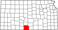 | |
| Unincorporated communities | ||
| Townships | ||