McKees Rocks Bridge
| McKees Rocks Bridge | |
|---|---|
 | |
| Coordinates | 40°28′37″N 80°02′56″W / 40.47704°N 80.0489°WCoordinates: 40°28′37″N 80°02′56″W / 40.47704°N 80.0489°W |
| Carries |
3 lanes of roadway |
| Crosses | Ohio River |
| Locale | McKees Rocks, Pennsylvania |
| Characteristics | |
| Design | Through arch bridge |
| Total length | 7,293 feet (2,223 m) |
| Longest span | 750 feet (228.6 m) |
| Clearance below | 100 feet (30 m) |
| History | |
| Opened | 1931 |
|
McKees Rocks Bridge | |
  | |
| Location | SR 3104 over Ohio River at Brighton Heights and McKees Rocks, Pennsylvania |
| Built | 1931 |
| Architect | Covell, V. R. |
| Architectural style | Other |
| MPS | Highway Bridges Owned by the Commonwealth of Pennsylvania, Department of Transportation TR |
| NRHP Reference # | 88002168 |
| Significant dates | |
| Added to NRHP | November 14, 1988[1] |
| Designated PHLF | 2003[2] |
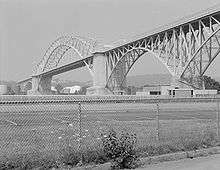
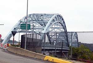
The McKees Rocks Bridge is a steel trussed through arch bridge which carries the Brown Belt across the Ohio River at Brighton Heights and McKees Rocks, Pennsylvania, west of Pittsburgh.
At 7,293 feet (2,223 m) long, it is the longest bridge in Allegheny County.[3]
Built in 1931, it was listed on the National Register of Historic Places in 1988.[1][4]
See also
- List of bridges documented by the Historic American Engineering Record in Pennsylvania
- List of crossings of the Ohio River
References
- 1 2 National Park Service (2008-04-15). "National Register Information System". National Register of Historic Places. National Park Service.
- ↑ Historic Landmark Plaques 1968-2009 (PDF). Pittsburgh, PA: Pittsburgh History & Landmarks Foundation. 2010. Retrieved 2011-08-05.
- ↑ Rotenstein, David S. (1997). "McKee's Rocks Bridge" (PDF). Historic American Engineering Record. Washington, D.C.: Library of Congress. Retrieved January 10, 2014.
- ↑ "McKees Rocks Bridge" (PDF). Pennsylvania Historic Resource Survey Form. Pennsylvania Historical and Museum Commission. Retrieved January 10, 2014.

The McKees Rocks Bridge from Island Avenue in McKees Rocks, Pennsylvania. This stretch of the bridge was the successor to the O'Donovan Bridge, which ran from Island Avenue to the "Bottoms" of McKees Rocks from 1904 to 1931.
External links
| Wikimedia Commons has media related to McKees Rocks Bridge. |
- Historic American Engineering Record (HAER) No. PA-445, "McKee's Rocks Bridge, Spanning Ohio River at Chartiers Avenue (State Route 3014), McKees Rocks, Allegheny County, PA", 17 photos, 15 data pages
- McKees Rocks Bridge at pghbridges.com
This article is issued from Wikipedia - version of the 11/20/2016. The text is available under the Creative Commons Attribution/Share Alike but additional terms may apply for the media files.

