Gweru
| Gweru | |||
|---|---|---|---|
 | |||
| |||
| Motto: Progress | |||
 Gweru | |||
| Coordinates: 19°27′41″S 29°48′08″E / 19.46139°S 29.80222°ECoordinates: 19°27′41″S 29°48′08″E / 19.46139°S 29.80222°E | |||
| Country | Zimbabwe | ||
| Province | Midlands | ||
| Founded | 1894 | ||
| City status | 1971 | ||
| Elevation | 1,424 m (4,672 ft) | ||
| Population (2013) | |||
| • Total | 141,862 | ||
| Time zone | CET (UTC+1) | ||
| • Summer (DST) | CEST (UTC+1) | ||
| Climate | Cwb | ||
.png)
Gweru (called Gwelo until 1982) is a city near the centre of Zimbabwe. It is the administrative capital of the Midlands Province, one of ten provinces in Zimbabwe. It became a municipality in 1914 and achieved city status in 1971. The name changed from Gwelo to Gweru in 1982. Before becoming a municipality, Gweru was known as "The Steep Place" after the Gweru river's high banks when it was first settled by the Matabele. Founded in 1894 by Dr. Leander Starr Jameson, modern Gweru was initially established as a military outpost.[1]
The Nalatale and Danangombe archaeological enclosures lie nearby, the former known for its patterned brickwork, the latter for its Portuguese remains. The remains at these sites date back to as early as the Torwa state during the 17th century, the most substantial being a four hundred-year-old stone wall decorated with motifs known to the tradition of stone-building in Zimbabwe. The surrounding area has rich deposits of gold, chrome, iron, asbestos and platinum and supports several mines.[1]
Gweru has become one of Africa's busiest trade centers thanks to its production of textiles, dairy foods, footware, and building materials. Gweru is also well-known for vibrant farming activities in beef cattle, crop farming, and commercial gardening of crops for the export market.[2]
Transportation
Railway
Railways arrived in Gweru in 1902. National Railways of Zimbabwe have the country's largest marshalling yard, Dabuka, on the south side of Gweru. Dabuka plays a pivotal role in rail movement in the country as it is the central hub of the rail links to Mozambique in the east, South Africa in the south and Botswana and Namibia in the south west, lying on the Bulawayo - Harare Line.
Roads
As a central city (hub), it has direct links to all the other cities and towns of Zimbabwe. It is 164 km from Bulawayo, 183 km from Masvingo, 471 km from Beitbridge, and 275 km from Harare.
Road names used are by destination only, for example the Harare - Gweru Road. There are only mainroads, no highways or freeways.[3]
Climate
| Climate data for Gweru (1961–1990) | |||||||||||||
|---|---|---|---|---|---|---|---|---|---|---|---|---|---|
| Month | Jan | Feb | Mar | Apr | May | Jun | Jul | Aug | Sep | Oct | Nov | Dec | Year |
| Average high °C (°F) | 26.3 (79.3) |
25.8 (78.4) |
25.8 (78.4) |
24.7 (76.5) |
22.9 (73.2) |
20.6 (69.1) |
20.5 (68.9) |
23.3 (73.9) |
26.8 (80.2) |
28.3 (82.9) |
27.4 (81.3) |
26.3 (79.3) |
24.9 (76.8) |
| Average low °C (°F) | 15.3 (59.5) |
15.1 (59.2) |
13.8 (56.8) |
11.3 (52.3) |
7.6 (45.7) |
4.9 (40.8) |
4.5 (40.1) |
6.5 (43.7) |
10.0 (50) |
13.1 (55.6) |
14.5 (58.1) |
15.1 (59.2) |
11.0 (51.8) |
| Average rainfall mm (inches) | 139.1 (5.476) |
124.8 (4.913) |
55.9 (2.201) |
29.0 (1.142) |
7.7 (0.303) |
1.9 (0.075) |
1.0 (0.039) |
1.9 (0.075) |
9.3 (0.366) |
35.1 (1.382) |
96.2 (3.787) |
159.4 (6.276) |
661.3 (26.035) |
| Average rainy days | 12 | 10 | 7 | 3 | 1 | 1 | 0 | 0 | 1 | 4 | 9 | 12 | 60 |
| Source: World Meteorological Organization[4] | |||||||||||||
International relations
Gweru shares an international relationship with the town of Basildon, (Essex, United Kingdom).[5]
Education
The primary and secondary system of education has not changed much in structure for several decades.
Primary schools
Group A
Cecil John Rhodes School
Stanley School
Lundi Park School
Midlands Christian School(Private)
Anderson Adventist (Private) Lingfield Academy (Private)
Group B
Bata School (Financed and Maintained by the Bata Shoe Company)
Sandara School
St Paul's School (Catholic)
Chikumbiro School
Bumburwi School
Muwunga School
St. Micheals Primary School (Catholic)
Senga Primary School
Matongo Primary School
Mpumelelo Primary School
Takunda Primary School
Mkoba 4 Primary School
Takwirira Primary school
Thornhill Airforce
- Secondary schools
Group A
- Chaplin High School (former school of Rhodesian Prime Minister - Ian Smith and Chris Duckworth, Rhodesia's foremost allround sportsman - Springbok cricketer, Rhodesian Hockey player, Natal U19, Junior Tennis Champion)
- Thornhill High School
- Midlands Christian College (private)
- Anderson Adventist High School (private)
- Nashville Secondary School
- Guinea Fowl High School
Group B
- Mkoba 3 High School
- Ascot Secondary School
- Matinunura Secondary school
- Senka Secondary School
- Mkoba 1 Secondary School
- Mambo Secondary School
- Fletcher High School (this school produced some of the country's top professionals)
- Tertiary Schools
- Gweru Polytechnic College
- Mkoba Teachers College
- Midlands State University
- Commercial colleges
Commercial education was not easily available to the majority of Gweru residents especially before independence. There was a surge of new colleges after 1980 when Zimbabwe gained independence and also when commercial courses became a popular requirement in industry.
Midlands College of Commerce It provided courses in most commercial and practical subjects popular during that era for example: typing, bookkeeping, dress-making and shorthand. These were examined by the UK-based Pitman Examinations Institute. This college stopped operating in the mid-1990s following the death of W.H Shumba in 1994.
After 1980 other colleges were soon established:
- Educare College
- Ambassador College
- Commercial Studies Centre
- Solars College
- TopFlight Secretarial College
- Herentals College
- Correspondence / Distance Education Colleges
- Zimbabwe Distance Education College (Zdeco). Founded by Dr Skhanyiso Ndlovu who is now the Minister of Information for Zimbabwe. ZDECO was formed soon after independence and is now one of the country's largest adult education colleges. This college runs commercial and academic programmes including ZJC (Zimbabwe Junior Certificate), 'O' and 'A' levels and degree programmes
- Central Africa Correspondence College established in 1954
- Rapid Results College established in 1962
- International Correspondence Schools
- Zimbabwe Open University (ZOU)
- Tertiary education
- Midlands Christian Training Centre - provided teacher training, and is also an examination centre for UNISA exams. This training centre is closely linked to the Midlands Christian School and College.
- Midlands State University - formerly Gweru Teacher's College www.msu.ac.zw
- Mkoba Teacher's College
- Senka Technical Training Centre
- Kaguvi National Technical College - formerly established to cater for freedom fighters who had gone to war against British colonial powers to reintegrate them into the community.
Sights
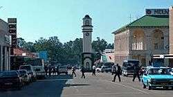
The Boggie Clock Tower, located at the intersection of Main Street and Robert Mugabe Way, was built in 1928 in memory of Major William James Boggie. The clock tower is one of the city's most famous landmarks.[1]
References
- 1 2 3 "Gweru - The City of Progress". www.mygweru.com. Retrieved 2016-11-14.
- ↑ "Gweru | Zimbabwe". Encyclopedia Britannica. Retrieved 2016-11-14.
- ↑ The Automobile Association of Zimbabwe
- ↑ "World Weather Information Service – Gweru". World Meteorological Organization. Retrieved 25 October 2015.
- ↑ Local Government International Bureau (LGIB) Database of "Twinning Towns
Capital: Gweru | |
| Dams/Reservoirs |
|
| Rivers |
|
| Highways/Roads |
|
| Museums/Monuments | |
| Settlements |
|
| Health Centres |
|
| Irrgation Schemes |
|
| Education |
|
| Culture and sport | |
| Notable People | |
| Constituencies |
|
| Industries | |
Parliament Research Department, Gweru Urban Constituency Profile, 'Parliament of Zimbabwe', Published: 2011, Retrieved: 28 Apr 2014