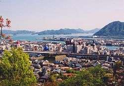
Mihara, Hiroshima
| Mihara 三原市 | ||
|---|---|---|
| City | ||
 | ||
| ||
|
Location of Mihara in Hiroshima Prefecture | ||
 Mihara Location in Japan | ||
| Coordinates: 34°24′N 133°5′E / 34.400°N 133.083°ECoordinates: 34°24′N 133°5′E / 34.400°N 133.083°E | ||
| Country | Japan | |
| Region | Chūgoku (San'yō) | |
| Prefecture | Hiroshima Prefecture | |
| Government | ||
| • Mayor | Sho Tenma | |
| Area | ||
| • Total | 471.03 km2 (181.87 sq mi) | |
| Population (July 31, 2016) | ||
| • Total | 97,324 | |
| • Density | 206.62/km2 (535.1/sq mi) | |
| Symbols | ||
| • Tree | Camphor laurel | |
| • Flower | Ume and Satsuki azalea | |
| Time zone | Japan Standard Time (UTC+9) | |
| City hall address |
3-5-1, Minatomachi, Mihara-shi, Hiroshima-ken 723-8601 | |
| Website |
www | |
Mihara (三原市 Mihara-shi) is a city located in Hiroshima Prefecture, Japan. The city was founded on November 15, 1936.
As of July 31, 2016, the city has an estimated population of 97,324 and a population density of 206.62 persons per km². The total area is 471.03 km².
On March 22, 2005, the town of Daiwa (from Kamo District), the town of Kui (from Mitsugi District), and the town of Hongō (from Toyota District) were merged into Mihara.
History
- Mihara Castle was established as a waterfront castle (Umi-jiro) by Kobayakawa Takakage in 1582.
- The castle has been connected to the Seto Inland Sea to operate the Mōri clan water forces on the sea.
- For the Battle of Sekigahara, Fukushima Masanori entered Hiroshima Castle in 1600, and then Mihara Castle has been under controlled as the branch castle of Hiroshima castle.
- The domain was divided into Fukuyama Domain and Hiroshima Domain in 1619, and Tadayoshi Asano entered Mihara castle.
- Mihara was incorporated into a part of Hiroshima Prefecture for the Abolition of the han system in 1871.
- Mihara city was founded on November 15, 1936.
- On March 22, 2005, the town of Daiwa (from Kamo District), the town of Kui (from Mitsugi District), and the town of Hongō (from Toyota District) were merged into Mihara.
A map of suburb of Mihara and Onomichi area in 1929 (Japanese edition)
Economy
Fisheries
- Shunami Port
- Nouji Port
Industries
- Mitsubishi Heavy Industries's Itozaki, Kohama and Wada Plants
- Teijin Mihara Plant
- Sharp Mihara Plant
- Dai Nippon Printing Mihara Plant
- Koyo Dockyard
- Mexichem Flúor Mihara Plant
Sister cities
-
 – Yugawara, Kanagawa, Japan
Educational Facilities
- Prefectural University of Hiroshima Mihara
- Mihara Nursing School
Transportation
Airports
Trains
- JR West lines
- Sanyō Shinkansen; Mihara Station
- Sanyō Main Line; Itozaki Station, Mihara and Hongo Station
- Kure Line; Mihara, Sunami Station and Akisaizaki Station
Buses
- Geiyo Bus
- Chugoku Bus
- Tomotetsu Bus
- Onomichi Bus
Highways
National Routes
- Japan National Route 2, 185, 486 and 432
Ports
- Mihara Port
- Onomichi-itozaki Port
- Sagi Port
- Sunami Port
Tourism
Castles
- Mihara Castle
- Nitakayama Castle
Temples
- Daizen-ji
- Buttsū-ji – Chūgoku 33 Kannon Pilgrimage #12
Shrines
- Mitsugi-hachimangu
Festivals
- Mihara Yassa Matsuri
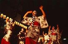
Yassa Festival in August
- Mihara Shinmeiichi Festival
- Satsuki Matsuri
People
Historical
Famous
- Ayako Miyake (三宅綾子), dancer
- Choji Murata (村田兆治), baseball player
- Ko Hiura (火浦功), novelist
- Yoshihisa Ishida (石田義久), shot putter
- Leyona, singer and songwriter
- Masatoshi Kawahara, manga artist
- Ryuji Imada, professional golfer
- Satoshi Urushihara, manga artist
- Hisatoshi Shintaku, long-distance runner
- Keiko Ikeda, Bronze medalist of 1964 Summer Olympics in Tokyo
Entertainment
A small island off the coast of Sagishima, called Sukune, was the location of Kaneto Shindo's film The Naked Island released in 1960.[1] Director Shindo and his wife Nobuko Otowa both had their ashes scattered on the island.[2]
References
- ↑ "A tourist guide to Sagishima" (in Japanese).
- ↑ "Shindo Kaneto Kantoku "Hadaka no Shima" Sankotsu e". Nikkan Sports.
External links
 Media related to Mihara, Hiroshima at Wikimedia Commons
- Mihara City official website (Japanese)
| Wards of Hiroshima | |
|---|---|
| Core cities | |
| Cities | |
| Aki District | |
| Jinseki District | |
| Sera District | |
| Toyota District | |
| Yamagata District | |
This article is issued from Wikipedia - version of the 8/20/2016. The text is available under the Creative Commons Attribution/Share Alike but additional terms may apply for the media files.