Morehouse Parish, Louisiana
| Morehouse Parish, Louisiana | |
|---|---|
|
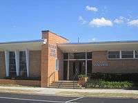
The Morehouse Parish Courthouse (built 1914) is located in the center of downtown Bastrop. | |
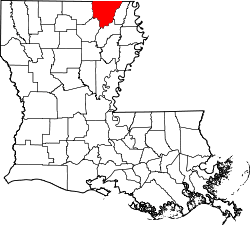 Location in the U.S. state of Louisiana | |
 Louisiana's location in the U.S. | |
| Founded | 1844 |
| Named for | Abraham Morehouse |
| Seat | Bastrop |
| Largest city | Bastrop |
| Area | |
| • Total | 806 sq mi (2,088 km2) |
| • Land | 795 sq mi (2,059 km2) |
| • Water | 11 sq mi (28 km2), 1.4% |
| Population | |
| • (2010) | 27,979 |
| • Density | 35/sq mi (14/km²) |
| Congressional district | 5th |
| Time zone | Central: UTC-6/-5 |

Morehouse Parish (French: Paroisse de Morehouse) is a parish located in the U.S. state of Louisiana. As of the 2010 census, the population was 29,979.[1] The parish seat is Bastrop.[2] The parish was formed in 1844.[3]
Morehouse Parish comprises the Bastrop, LA Micropolitan Statistical Area, which is included in the Monroe-Ruston-Bastrop, LA Combined Statistical Area.
Geography
According to the U.S. Census Bureau, the parish has a total area of 806 square miles (2,090 km2), of which 795 square miles (2,060 km2) is land and 11 square miles (28 km2) (1.4%) is water.[4]
Major highways
Adjacent counties and parishes
- Union County, Arkansas (northwest)
- Ashley County, Arkansas (north)
- Chicot County, Arkansas (northeast)
- West Carroll Parish (east)
- Richland Parish (southeast)
- Ouachita Parish (southwest)
- Union Parish (west)
National protected areas
Demographics
| Historical population | |||
|---|---|---|---|
| Census | Pop. | %± | |
| 1850 | 3,913 | — | |
| 1860 | 10,357 | 164.7% | |
| 1870 | 9,387 | −9.4% | |
| 1880 | 14,206 | 51.3% | |
| 1890 | 16,786 | 18.2% | |
| 1900 | 16,634 | −0.9% | |
| 1910 | 18,786 | 12.9% | |
| 1920 | 19,311 | 2.8% | |
| 1930 | 23,689 | 22.7% | |
| 1940 | 27,571 | 16.4% | |
| 1950 | 32,038 | 16.2% | |
| 1960 | 33,709 | 5.2% | |
| 1970 | 32,463 | −3.7% | |
| 1980 | 34,803 | 7.2% | |
| 1990 | 31,938 | −8.2% | |
| 2000 | 31,021 | −2.9% | |
| 2010 | 27,979 | −9.8% | |
| Est. 2015 | 26,395 | [5] | −5.7% |
| U.S. Decennial Census[6] 1790-1960[7] 1900-1990[8] 1990-2000[9] 2010-2013[1] | |||
As of the 2010 United States Census, there were 27,979 people residing in the parish. 51.3% were White, 46.9% Black or African American, 0.4% Asian, 0.1% Native American, 0.1% Pacific Islander, 0.3% of some other race and 1.0% of two or more races. 0.9% were Hispanic or Latino (of any race).
As of the census[10] of 2000, there were 31,021 people, 11,382 households, and 8,320 families residing in the parish. The population density was 39 people per square mile (15/km²). There were 12,711 housing units at an average density of 16 per square mile (6/km²). The racial makeup of the parish was 55.76% White, 43.36% Black or African American, 0.13% Native American, 0.18% Asian, 0.01% Pacific Islander, 0.12% from other races, and 0.44% from two or more races. 0.74% of the population were Hispanic or Latino of any race.
There were 11,382 households out of which 33.30% had children under the age of 18 living with them, 49.10% were married couples living together, 19.80% had a female householder with no husband present, and 26.90% were non-families. 24.40% of all households were made up of individuals and 11.60% had someone living alone who was 65 years of age or older. The average household size was 2.64 and the average family size was 3.14.
In the parish the population was spread out with 27.50% under the age of 18, 9.50% from 18 to 24, 26.40% from 25 to 44, 21.40% from 45 to 64, and 15.10% who were 65 years of age or older. The median age was 36 years. For every 100 females there were 91.40 males. For every 100 females age 18 and over, there were 86.10 males.
The median income for a household in the parish was $25,124, and the median income for a family was $31,358. Males had a median income of $31,385 versus $18,474 for females. The per capita income for the parish was $13,197. About 21.30% of families and 26.80% of the population were below the poverty line, including 35.90% of those under age 18 and 23.80% of those age 65 or over.
Politics
In 1975, Edwards Barham, a farmer and businessman from Oak Ridge in Morehouse Parish, became the first Republican elected to the Louisiana State Senate since the era of Reconstruction. Barham won his seat by twenty-nine votes. He was unseated after a single term in office in 1979 by the Democrat David 'Bo' Ginn of Bastrop.
In the 2012 U.S. presidential election, Morehouse Parish cast 6,591 votes (52.3 percent) for Republican nominee Mitt Romney. U.S. President Barack Obama trailed with 5,888 ballots (46.7 percent).[11] These results nearly identically parallel the racial complexion of Morehouse Parish. In 2008, Republican John McCain prevailed in Morehouse Parish with 7,258 votes (55 percent) to Barack Obama's 5,792 ballots (43.9 percent).[12]
Education
Morehouse Parish School Board operates local public schools.
National Guard
1023rd Engineer Company (Vertical) of the 528th Engineer Battalion of the 225th Engineer Brigade is located in Bastrop, Louisiana.
Communities
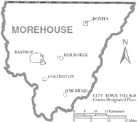
- Bastrop (parish seat)
- Bonita
- Collinston
- Mer Rouge
- Oak Ridge
See also
References
- 1 2 "State & County QuickFacts". United States Census Bureau. Retrieved August 10, 2013.
- ↑ "Find a County". National Association of Counties. Retrieved 2011-06-07.
- ↑ "Morehouse Parish". Center for Cultural and Eco-Tourism. Retrieved September 5, 2014.
- ↑ "2010 Census Gazetteer Files". United States Census Bureau. August 22, 2012. Retrieved September 1, 2014.
- ↑ "County Totals Dataset: Population, Population Change and Estimated Components of Population Change: April 1, 2010 to July 1, 2015". Retrieved July 2, 2016.
- ↑ "U.S. Decennial Census". United States Census Bureau. Retrieved September 1, 2014.
- ↑ "Historical Census Browser". University of Virginia Library. Retrieved September 1, 2014.
- ↑ "Population of Counties by Decennial Census: 1900 to 1990". United States Census Bureau. Retrieved September 1, 2014.
- ↑ "Census 2000 PHC-T-4. Ranking Tables for Counties: 1990 and 2000" (PDF). United States Census Bureau. Retrieved September 1, 2014.
- ↑ "American FactFinder". United States Census Bureau. Retrieved 2008-01-31.
- ↑ "Louisiana general election returns, November 6, 2012". staticresults.sos.la.gov. Retrieved December 7, 2012.
- ↑ "Louisiana general election returns, November 4, 2008". staticresults.sos.la.gov. Retrieved December 7, 2012.
 |
Union County, Arkansas | Ashley County, Arkansas | Chicot County, Arkansas | |
| Union Parish | |
West Carroll Parish | ||
| ||||
| | ||||
| Ouachita Parish | Richland Parish |
Municipalities and communities of Morehouse Parish, Louisiana, United States | ||
|---|---|---|
| Cities | | |
| Villages | ||
| Unincorporated community | ||
Coordinates: 32°49′N 91°48′W / 32.82°N 91.80°W