List of mountains and mountain ranges of Yellowstone National Park

Mountain Ranges of Yellowstone
Yellowstone National Park, located primarily in the U.S. state of Wyoming, though the park also extends into Montana and Idaho and its Mountains and Mountain Ranges are part of the Rocky Mountains. There are at least 70 named mountain peaks over 8,000 feet (2,400 m) in Yellowstone in four mountain ranges. Two of the ranges—The Washburn Range and the Red Mountains—are minor and completely enclosed within park boundaries. The other two ranges are major, multi-state ranges that extend far beyond the boundaries of the park. The Gallatin Range begins approximately 75 miles (121 km) north of Yellowstone near Bozeman, Montana and dominates the northwest corner of the park. The Absaroka Range, the largest range in the park, begins approximately 80 miles (130 km) miles north of the park near Livingston, Montana along the Yellowstone River and runs southeast into, then south through the entire eastern side of the park to the Wind River Range in Wyoming. The highest peak in the park, Eagle Peak is in the Absaroka Range. Yellowstone also has several isolated peaks over 8,000 feet (2,400 m) on the plateaus that dominate the central, western and southwestern sections of the park.[1]
Absaroka Range
- Eagle Peak - el. 11,358 feet (3,462 m); 44°19′15″N 110°01′40″W / 44.32083°N 110.02778°W / 44.32083; -110.02778 (Eagle Peak)[2]
- Mount Schurz - el. 11,007 feet (3,355 m); 44°20′33″N 110°04′19″W / 44.34250°N 110.07194°W / 44.34250; -110.07194 (Mount Schurz)[3]
- Abiathar Peak - el. 10,928 feet (3,331 m); 44°58′31″N 110°01′56″W / 44.97528°N 110.03222°W / 44.97528; -110.03222 (Abiathar Peak)[4]
- Atkins Peak - el. 10,928 feet (3,331 m); 44°22′33″N 110°04′08″W / 44.37583°N 110.06889°W / 44.37583; -110.06889 (Atkins Peak)[5]
- Pollux Peak - el. 10,984 feet (3,348 m); 44°40′00″N 109°55′45″W / 44.66667°N 109.92917°W / 44.66667; -109.92917 (Pollux Peak)[6]
- Grant Peak - el. 10,850 feet (3,310 m); 44°37′49″N 109°56′50″W / 44.63028°N 109.94722°W / 44.63028; -109.94722 (Grant Peak)[7]
- Turret Mountain - el. 10,840 feet (3,300 m); 44°16′22″N 110°03′38″W / 44.27278°N 110.06056°W / 44.27278; -110.06056 (Turret Mountain)[8]
- Castor Peak - el. 10,804 feet (3,293 m); 44°39′25″N 109°57′19″W / 44.65694°N 109.95528°W / 44.65694; -109.95528 (Castor Peak)[9]
- Colter Peak - el. 10,640 feet (3,240 m); 44°18′06″N 110°06′36″W / 44.30167°N 110.11000°W / 44.30167; -110.11000 (Colter Peak)[10]
- Mount Langford - el. 10,623 feet (3,238 m); 44°24′25″N 110°06′37″W / 44.40694°N 110.11028°W / 44.40694; -110.11028 (Mount Langford)[11]
- The Trident - el. 10,620 feet (3,240 m); 44°11′36″N 110°00′43″W / 44.19333°N 110.01194°W / 44.19333; -110.01194 (The Trident)[12]
- Reservation Peak - el. 10,617 feet (3,236 m); 44°25′54″N 110°01′37″W / 44.43167°N 110.02694°W / 44.43167; -110.02694 (Reservation Peak)[13]
- Silvertip Peak - el. 10,613 feet (3,235 m); 44°31′27″N 110°06′13″W / 44.52417°N 110.10361°W / 44.52417; -110.10361 (Silvertip Peak)[14]
- Mount Doane - el. 10,551 feet (3,216 m); 44°24′49″N 110°08′53″W / 44.41361°N 110.14806°W / 44.41361; -110.14806 (Mount Doane)[15]
- Cathedral Peak - el. 10,548 feet (3,215 m); 44°34′14″N 110°06′39″W / 44.57056°N 110.11083°W / 44.57056; -110.11083 (Cathedral Peak)[16]
- The Thunderer - el. 10,495 feet (3,199 m); 44°54′12″N 110°03′24″W / 44.90333°N 110.05667°W / 44.90333; -110.05667 (The Thunderer)[17]
- Meridan Peak - el. 10,466 feet (3,190 m); 45°01′38″N 110°00′09″W / 45.02722°N 110.00250°W / 45.02722; -110.00250 (Meridan Peak)[18]
- Avalanche Peak (Wyoming) - el. 10,440 feet (3,180 m); 44°29′23″N 110°08′28″W / 44.48972°N 110.14111°W / 44.48972; -110.14111 (Avalanche Peak)[19]
- Republic Peak - el. 10,410 feet (3,170 m); 44°57′03″N 109°56′59″W / 44.95083°N 109.94972°W / 44.95083; -109.94972 (Republic Peak)[20]
- Saddle Mountain - el. 10,394 feet (3,168 m); 44°42′39″N 109°59′01″W / 44.71083°N 109.98361°W / 44.71083; -109.98361 (Saddle Mountain)[21]
- Arthur Peak - el. 10,364 feet (3,159 m); 44°25′29″N 110°02′21″W / 44.42472°N 110.03917°W / 44.42472; -110.03917 (Arthur Peak)[22]
- Barronette Peak - el. 10,354 feet (3,156 m); 44°58′31″N 110°05′19″W / 44.97528°N 110.08861°W / 44.97528; -110.08861 (Barronette Peak)[23]
- Hoyt Peak - el. 10,344 feet (3,153 m); 44°28′38″N 110°07′43″W / 44.47722°N 110.12861°W / 44.47722; -110.12861 (Hoyt Peak)[24]
- Hague Mountain - el. 10,292 feet (3,137 m); 44°42′21″N 110°00′02″W / 44.70583°N 110.00056°W / 44.70583; -110.00056 (Hague Mountain)[25]
- Amphitheater Mountain - el. 10,239 feet (3,121 m); 44°58′21″N 110°00′25″W / 44.97250°N 110.00694°W / 44.97250; -110.00694 (Amphitheater Mountain)[26]
- Mount Stevenson - el. 10,230 feet (3,120 m); 44°24′06″N 110°09′34″W / 44.40167°N 110.15944°W / 44.40167; -110.15944 (Mount Stevenson)[27]
- Cody Peak - el. 10,138 feet (3,090 m); 44°30′03″N 110°01′45″W / 44.50083°N 110.02917°W / 44.50083; -110.02917 (Cody Peak)[28]
- Parker Peak - el. 10,095 feet (3,077 m); 44°43′24″N 109°53′39″W / 44.72333°N 109.89417°W / 44.72333; -109.89417 (Parker Peak)[29]
- Mount Chittenden - el. 10,088 feet (3,075 m); 44°32′48″N 110°10′16″W / 44.54667°N 110.17111°W / 44.54667; -110.17111 (Mount Chittenden)[30]
- Top Notch Peak - el. 10,062 feet (3,067 m); 44°27′08″N 110°08′40″W / 44.45222°N 110.14444°W / 44.45222; -110.14444 (Top Notch Peak)[31]
- Mount Hornaday - el. 10,003 feet (3,049 m); 44°56′42″N 110°08′46″W / 44.94500°N 110.14611°W / 44.94500; -110.14611 (Mount Hornaday)[32]
- Grizzly Peak - el. 9,915 feet (3,022 m); 44°28′07″N 110°10′34″W / 44.46861°N 110.17611°W / 44.46861; -110.17611 (Grizzly Peak)[33]
- The Needle - el. 9,862 feet (3,006 m); 44°51′56″N 110°00′13″W / 44.86556°N 110.00361°W / 44.86556; -110.00361 (The Needle)[34]
- Mount Norris - el. 9,842 feet (3,000 m); 44°52′28″N 110°05′41″W / 44.87444°N 110.09472°W / 44.87444; -110.09472 (Mount Norris)[35]
- Cache Mountain - el. 9,593 feet (2,924 m); 44°53′40″N 109°58′35″W / 44.89444°N 109.97639°W / 44.89444; -109.97639 (Cache Mountain)[36]
- Druid Peak - el. 9,577 feet (2,919 m); 44°54′16″N 110°10′45″W / 44.90444°N 110.17917°W / 44.90444; -110.17917 (Druid Peak)[37]
- Frederick Peak - el. 9,475 feet (2,888 m); 44°55′45″N 110°11′36″W / 44.92917°N 110.19333°W / 44.92917; -110.19333 (Frederick Peak)[38]
- Bison Peak - el. 8,924 feet (2,720 m); 44°56′33″N 110°13′37″W / 44.94250°N 110.22694°W / 44.94250; -110.22694 (Bison Peak)[39]
Gallatin Range
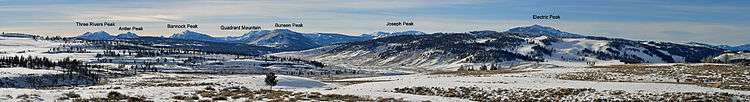
| Gallatin Range Panorama |
|---|
| From Blacktail Plateau, 2010 |
|
- Electric Peak - el. 10,969 feet (3,343 m); 45°00′19″N 110°50′12″W / 45.00528°N 110.83667°W / 45.00528; -110.83667 (Electric Peak)[40]
- Joseph Peak - el. 10,420 feet (3,180 m); 44°57′31″N 110°53′05″W / 44.95861°N 110.88472°W / 44.95861; -110.88472 (Joseph Peak)[41]
- Mount Holmes - el. 10,331 feet (3,149 m); 44°49′08″N 110°51′21″W / 44.81889°N 110.85583°W / 44.81889; -110.85583 (Mount Holmes)[42]
- Gray Peak - el. 10,298 feet (3,139 m); 44°56′41″N 110°52′49″W / 44.94472°N 110.88028°W / 44.94472; -110.88028 (Gray Peak)[43]
- Bannock Peak - el. 10,292 feet (3,137 m); 44°53′30″N 110°52′21″W / 44.89167°N 110.87250°W / 44.89167; -110.87250 (Bannock Peak)[44]
- Antler Peak - el. 10,063 feet (3,067 m); 44°52′07″N 110°50′11″W / 44.86861°N 110.83639°W / 44.86861; -110.83639 (Antler Peak)[45]
- Trilobite Point - el. 10,010 feet (3,050 m); 44°49′01″N 110°50′38″W / 44.81694°N 110.84389°W / 44.81694; -110.84389 (Trilobite Point)[46]
- Quadrant Mountain - el. 9,954 feet (3,034 m); 44°54′14″N 110°49′56″W / 44.90389°N 110.83222°W / 44.90389; -110.83222 (Quadrant Mountain)[47]
- Dome Mountain - el. 9,826 feet (2,995 m); 44°50′22″N 110°50′27″W / 44.83944°N 110.84083°W / 44.83944; -110.84083 (Dome Mountain)[48]
- Three Rivers Peak - el. 9,764 feet (2,976 m); 44°51′01″N 110°53′00″W / 44.85028°N 110.88333°W / 44.85028; -110.88333 (Three Rivers Peak)[49]
- Sepulcher Mountain - el. 9,642 feet (2,939 m); 44°59′25″N 110°46′01″W / 44.99028°N 110.76694°W / 44.99028; -110.76694 (Sepulcher Mountain)[50]
- Echo Peak - el. 9,570 feet (2,920 m); 44°50′52″N 110°52′59″W / 44.84778°N 110.88306°W / 44.84778; -110.88306 (Echo Peak)[51]
- White Peaks - el. 9,472 feet (2,887 m); 44°48′52″N 110°52′25″W / 44.81444°N 110.87361°W / 44.81444; -110.87361 (White Peaks)[52]
- Meldrum Mountain - el. 9,468 feet (2,886 m); 45°02′51″N 111°00′57″W / 45.04750°N 111.01583°W / 45.04750; -111.01583 (Meldrum Mountain)[53]
- Bunsen Peak - el. 8,527 feet (2,599 m); 44°55′54″N 110°42′25″W / 44.93167°N 110.70694°W / 44.93167; -110.70694 (Bunsen Peak)[54]
- Purple Mountain - el. 8,392 feet (2,558 m); 44°40′02″N 110°51′44″W / 44.66722°N 110.86222°W / 44.66722; -110.86222 (Purple Mountains)[55]
- Mount Jackson - el. 8,231 feet (2,509 m); 44°39′09″N 110°55′46″W / 44.65250°N 110.92944°W / 44.65250; -110.92944 (Mount Jackson)[56]
- Mount Haynes - el. 8,218 feet (2,505 m);44°37′58″N 110°56′46″W / 44.63278°N 110.94611°W / 44.63278; -110.94611 (Mount Haynes)[57]
- Clagett Butte - el. 8,041 feet (2,451 m); 44°57′52″N 110°44′06″W / 44.96444°N 110.73500°W / 44.96444; -110.73500 (Clagett Butte)[58]
- Terrace Mountain - el. 8,002 feet (2,439 m) 44°57′20″N 110°44′08″W / 44.95556°N 110.73556°W / 44.95556; -110.73556 (Terrace Mountain)[59]
- Three Brothers Mountains - el. 7,116 feet (2,169 m) 44°37′59″N 110°53′16″W / 44.63306°N 110.88778°W / 44.63306; -110.88778 (Three Brothers Mountains)[60]
- Mount Everts - el. 7,831 feet (2,387 m); 44°58′30″N 110°39′41″W / 44.97500°N 110.66139°W / 44.97500; -110.66139 (Mount Everts)[61]
Washburn Range
- Mount Washburn - el. 10,223 feet (3,116 m); 44°47′51″N 110°26′00″W / 44.79750°N 110.43333°W / 44.79750; -110.43333 (Mount Washburn)[62]
- Dunraven Peak - el. 9,869 feet (3,008 m); 44°46′58″N 110°28′10″W / 44.78278°N 110.46944°W / 44.78278; -110.46944 (Dunraven Peak)[63]
- Cook Peak - el. 9,754 feet (2,973 m); 44°50′34″N 110°34′31″W / 44.84278°N 110.57528°W / 44.84278; -110.57528 (Cook Peak)[64]
- Hedges Peak - el. 9,669 feet (2,947 m); 44°46′39″N 110°28′47″W / 44.77750°N 110.47972°W / 44.77750; -110.47972 (Hedges Peak)[65]
- Amethyst Mountain - el. 9,609 feet (2,929 m); 44°49′43″N 110°15′15″W / 44.82861°N 110.25417°W / 44.82861; -110.25417 (Amethyst Mountain)Coordinates: 44°49′43″N 110°15′15″W / 44.82861°N 110.25417°W / 44.82861; -110.25417 (Amethyst Mountain)[66]
- Prospect Peak - el. 9,527 feet (2,904 m); 44°53′17″N 110°30′10″W / 44.88806°N 110.50278°W / 44.88806; -110.50278 (Prospect Peak)[67]
- Observation Peak - el. 9,390 feet (2,860 m); 44°46′19″N 110°32′53″W / 44.77194°N 110.54806°W / 44.77194; -110.54806 (Observation Peak)[68]
- Folsom Peak - el. 9,334 feet (2,845 m); 44°52′22″N 110°32′51″W / 44.87278°N 110.54750°W / 44.87278; -110.54750 (Folsom Peak)[69]
- Specimen Ridge - el. 8,379 feet (2,554 m); 44°52′13″N 110°17′48″W / 44.87028°N 110.29667°W / 44.87028; -110.29667 (Specimen Ridge)[70]
Red Mountains
Isolated summits
- Mount Hancock - el. 10,223 feet (3,116 m); 44°09′19″N 110°25′03″W / 44.15528°N 110.41750°W / 44.15528; -110.41750 (Mount Hancock)[73]
- Barlow Peak - el. 9,609 feet (2,929 m); 44°10′58″N 110°22′38″W / 44.18278°N 110.37722°W / 44.18278; -110.37722 (Barlow Peak)[74]
- Channel Mountain - el. 8,750 feet (2,670 m); 44°16′35″N 110°22′29″W / 44.27639°N 110.37472°W / 44.27639; -110.37472 (Channel Mountain)[75]
- Elephant Back Mountain - el. 8,592 feet (2,619 m); 44°33′15″N 110°28′02″W / 44.55417°N 110.46722°W / 44.55417; -110.46722 (Elephant Back Mountain)[76]
- Trischman Knob - el. 8,573 feet (2,613 m); 44°20′22″N 110°52′39″W / 44.33944°N 110.87750°W / 44.33944; -110.87750 (Trischman Knob)[77]
- Douglas Knob - el. 8,507 feet (2,593 m); 44°18′48″N 110°50′51″W / 44.31333°N 110.84750°W / 44.31333; -110.84750 (Douglas Knob)[78]
- Horseshoe Hill - el. 8,274 feet (2,522 m); 44°50′14″N 110°40′50″W / 44.83722°N 110.68056°W / 44.83722; -110.68056 (Horseshoe Hill)[79]
- Roaring Mountain - el 8,153 feet (2,485 m); 44°46′38″N 110°43′39″W / 44.77722°N 110.72750°W / 44.77722; -110.72750 (Roaring Mountain)[80]
See also
Notes