Mount Walker, Queensland
| Mount Walker Queensland | |||||||||||||
|---|---|---|---|---|---|---|---|---|---|---|---|---|---|
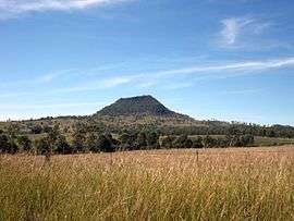 Mount Walker viewed from Rosewood Warrill View Road, 2015 | |||||||||||||
 Mount Walker | |||||||||||||
| Coordinates | 27°46′36″S 152°33′26″E / 27.7767°S 152.5571°ECoordinates: 27°46′36″S 152°33′26″E / 27.7767°S 152.5571°E | ||||||||||||
| Population | 392 (2011 census)[1] | ||||||||||||
| Postcode(s) | 4340 | ||||||||||||
| LGA(s) | Scenic Rim Region | ||||||||||||
| State electorate(s) | Beaudesert | ||||||||||||
| Federal Division(s) | Wright | ||||||||||||
| |||||||||||||
Mount Walker is a mountain and locality in the Scenic Rim Region of Queensland, Australia.[2][3] The western boundary of Mount Walker is marked by the Bremer River. The central eastern parts of the locality rise to elevations above 400 m around Mount Walker. At the 2011 Australian Census Mount Walker and surrounds recorded a population of 392.[1]
History
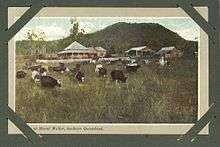
The mountain was originally called Mount Forbes by John Oxley in honour of Sir Francis Forbes, the Chief Justice of New South Wales. However, it was later acquired the name Mount Walker. The origins of the name Walker are believed to be a shepherd of that name from the Franklyn Vale pastoral station.[2] The locality takes its name from the mountain.[3]
The Mount Walker State School opened on 15 April 1878. It closed in December 1967.[4][5]
Mount Walker Post Office opened on 1 October 1916 (a receiving office had been open from 1874) and closed in 1957.[6]
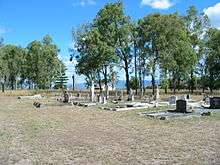
The historic Mount Walker Public Cemetery is located at 1744-1752 Rosewood-Warrill View Road (27°46′44″S 152°32′08″E / 27.7788°S 152.5356°E).[7]
Amenities
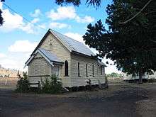
The Mount Walker Church of Christ is located at 10 Hinrichsen Road, just off the Rosewood-Warrill View Road (27°46′22″S 152°32′15″E / 27.7729°S 152.5374°E); weekly Sunday services are held at the church.[8] The church opened in 1884 and celebrated its 125th anniversary in 2009.[9]
References
- 1 2 Australian Bureau of Statistics (31 October 2012). "Mount Walker (Gazetted Locality)". 2011 Census QuickStats. Retrieved 10 April 2015.
- 1 2 "Mount Walker (mountain) (entry 36227)". Queensland Place Names. Queensland Government. Retrieved 15 September 2013.
- 1 2 "Mount Walker (locality) (entry 45216)". Queensland Place Names. Queensland Government. Retrieved 15 September 2013.
- ↑ "Opening and closing dates of Queensland Schools". Queensland Government. Retrieved 13 April 2015.
- ↑ "Agency ID6387, Mount Walker State School". Queensland State Archives. Retrieved 13 April 2015.
- ↑ Premier Postal History. "Post Office List". Premier Postal Auctions. Retrieved 10 May 2014.
- ↑ "Mt Walker historic cemetery, Boonah Shire". Retrieved 13 April 2015.
- ↑ "Find us". Church of Christ Queensland. Retrieved 13 April 2015.
- ↑ "Mt Walker's 125th Church Anniversary Celebrations" (PDF). Networking: Magazine of Churches of Christ in Queensland. Church of Christ Queensland (19). Spring 2009. Retrieved 13 April 2015.
External links
![]() Media related to Mount Walker, Queensland at Wikimedia Commons
Media related to Mount Walker, Queensland at Wikimedia Commons