National Register of Historic Places listings in Banks County, Georgia
This is a list of properties and districts in Banks County, Georgia that are listed on the National Register of Historic Places (NRHP).
- This National Park Service list is complete through NPS recent listings posted December 16, 2016.[1]
Current listings
| [2] | Name on the Register | Image | Date listed[3] | Location | City or town | Description |
|---|---|---|---|---|---|---|
| 1 | Banks County Courthouse | .jpg) |
(#80000969) |
Off U.S. 441 34°20′05″N 83°29′56″W / 34.334722°N 83.498889°W |
Homer | |
| 2 | Banks County Jail | 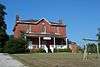 |
(#82002382) |
Silver Shoals Rd. 34°20′06″N 83°29′20″W / 34.335°N 83.488889°W |
Homer | |
| 3 | Brooks Family Farm | 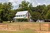 |
(#13000529) |
584 Silver Shoals Rd. 34°22′14″N 83°33′14″W / 34.3706558°N 83.5538831°W |
Lula | |
| 4 | William Chambers House | .JPG) |
(#96001305) |
GA 51, approximately 1 mi. W of jct. with GA 63 34°22′15″N 83°25′13″W / 34.370833°N 83.420278°W |
Homer | |
| 5 | Fort Hollingsworth-White House | .JPG) |
(#19980806) |
Wynn Lake Rd., 2 mi. SE of Hollingsworth 34°25′35″N 83°32′02″W / 34.426389°N 83.533889°W |
Hollingsworth | |
| 6 | Gillsville Historic District | 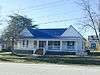 |
(#85001933) |
GA 52 34°18′38″N 83°38′20″W / 34.310556°N 83.638889°W |
Gillsville | |
| 7 | Hebron Church, Cemetery, and Academy | .JPG) |
(#85002176) |
Hebron Circle 34°17′12″N 83°21′53″W / 34.286667°N 83.364722°W |
Commerce | |
| 8 | Homer Historic District | .JPG) |
(#85003110) |
Along Main St. and Silver Shoals Rd. 34°19′59″N 83°29′52″W / 34.333056°N 83.497778°W |
Homer | |
| 9 | Kesler Covered Bridge | Upload image | (#75000571) |
10 mi. N of Homer on County Line Rd. over Middle Fork Broad River 34°25′27″N 83°23′16″W / 34.424167°N 83.387778°W |
Homer | |
| 10 | Maysville Historic District | 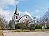 |
(#85002203) |
Along E. Main, W. Main and Homer Sts. 34°15′17″N 83°33′48″W / 34.254722°N 83.563333°W |
Maysville | |
| 11 | Mount Pleasant Historic District | .JPG) |
(#96001306) |
Jct. of GA 51 and Damascus Road 34°21′53″N 83°26′33″W / 34.3646°N 83.4426°W |
Homer | |
| 12 | Nails Creek Historic District | 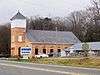 |
(#96001307) |
Jct. of GA 51 and GA 63 34°22′00″N 83°24′02″W / 34.366667°N 83.400556°W |
Homer | |
| 13 | New Salem Covered Bridge | Upload image | (#75000570) |
6 mi. N of Commerce on SR S992 over Grove Creek 34°15′30″N 83°25′20″W / 34.258333°N 83.422222°W |
Commerce | |
| 14 | Turk Family Farm | Upload image | (#03001365) |
534 Carson Segars Rd. 34°17′37″N 83°32′43″W / 34.293611°N 83.545278°W |
Maysville |
References
- ↑ "National Register of Historic Places: Weekly List Actions". National Park Service, United States Department of the Interior. Retrieved on December 16, 2016.
- ↑ Numbers represent an ordering by significant words. Various colorings, defined here, differentiate National Historic Landmarks and historic districts from other NRHP buildings, structures, sites or objects.
- ↑ The eight-digit number below each date is the number assigned to each location in the National Register Information System database, which can be viewed by clicking the number.
| Wikimedia Commons has media related to National Register of Historic Places in Banks County, Georgia. |
| Topics | |
|---|---|
| Lists by states |
|
| Lists by insular areas | |
| Lists by associated states | |
| Other areas | |
| |
This article is issued from Wikipedia - version of the 8/18/2016. The text is available under the Creative Commons Attribution/Share Alike but additional terms may apply for the media files.