| [3] |
Name on the Register[4] |
Image |
Date listed[5] |
Location |
City or town |
Description |
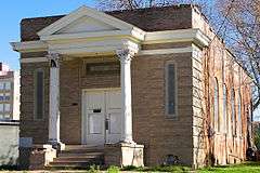
|---|
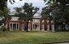
| 1 |
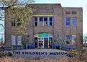
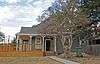
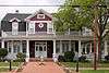
Allen Academy Memorial Hall |
Upload image |
000000001987-09-25-0000September 25, 1987
(#87001603) |
1100 blk. of Ursuline
30°40′35″N 96°21′43″W / 30.676389°N 96.361944°W / 30.676389; -96.361944 (Allen Academy Memorial Hall) |
Bryan |
|
| 2 |
Allen Block |
Upload image |
000000001987-09-25-0000September 25, 1987
(#87001604) |
400-422 N. Main St.
30°40′37″N 96°22′23″W / 30.67686°N 96.37307°W / 30.67686; -96.37307 (Allen Block) |
Bryan |
|
| 3 |
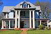
R. O. Allen House-Allen Academy |
Upload image |
000000001987-09-25-0000September 25, 1987
(#87001605) |
1120 Ursuline
30°40′35″N 96°21′37″W / 30.676389°N 96.360278°W / 30.676389; -96.360278 (R. O. Allen House-Allen Academy) |
Bryan |
|
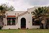
| 4 |
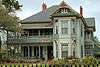
Armstrong House-Allen Academy |
Upload image |
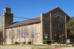
000000001987-09-25-0000September 25, 1987
(#87001606) |
1200 Ursuline
30°40′34″N 96°21′35″W / 30.676111°N 96.359722°W / 30.676111; -96.359722 (Armstrong House-Allen Academy) |
Bryan |
|
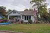
| 5 |
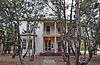
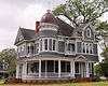
R. Q. Astin House |
|
000000001987-09-25-0000September 25, 1987
(#87001607) |
508 W. 26th St.
30°40′29″N 96°22′41″W / 30.67465°N 96.37793°W / 30.67465; -96.37793 (R. Q. Astin House) |
Bryan |
|
| 6 |
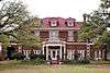
E. J. Blazek House |
|
000000001987-09-25-0000September 25, 1987
(#87001608) |
409 W. 30th St.
30°40′13″N 96°22′39″W / 30.67014°N 96.37763°W / 30.67014; -96.37763 (E. J. Blazek House) |
Bryan |
|
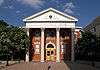
| 7 |
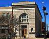
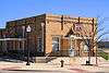
Bryan Carnegie Library |
|
000000001976-10-27-0000October 27, 1976
(#76002009) |
111 S. Main St.
30°40′23″N 96°22′24″W / 30.67301°N 96.37324°W / 30.67301; -96.37324 (Bryan Carnegie Library) |
Bryan |
|
| 8 |
Bryan Compress and Warehouse |
Upload image |
000000001987-09-25-0000September 25, 1987
(#87001609) |
911 N. Bryan Ave.
30°40′55″N 96°22′22″W / 30.68196°N 96.37270°W / 30.68196; -96.37270 (Bryan Compress and Warehouse) |
Bryan |
|
| 9 |
Bryan Ice House |
|
000000001987-09-25-0000September 25, 1987
(#87001610) |
107 E. Martin Luther King
30°40′48″N 96°22′20″W / 30.67994°N 96.37224°W / 30.67994; -96.37224 (Bryan Ice House) |
Bryan |
|
| 10 |
Bryan Municipal Building |
|
000000002002-02-20-0000February 20, 2002
(#02000116) |
111 E. 27th St.
30°40′21″N 96°22′20″W / 30.67250°N 96.37234°W / 30.67250; -96.37234 (Bryan Municipal Building) |
Bryan |
|
| 11 |
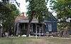
Cavitt House |
|
000000001976-10-27-0000October 27, 1976
(#76002010) |
713 E. 30th St.
30°40′01″N 96°22′00″W / 30.66691°N 96.36659°W / 30.66691; -96.36659 (Cavitt House) |
Bryan |
|
| 12 |
James O. Chance House |
Upload image |
000000001987-09-25-0000September 25, 1987
(#87001612) |
102 S. Parker Ave.
30°40′25″N 96°22′31″W / 30.67372°N 96.37541°W / 30.67372; -96.37541 (James O. Chance House) |
Bryan |
|
| 13 |
CSPS Lodge-Griesser Bakery |
Upload image |
000000001987-09-25-0000September 25, 1987
(#87001611) |
304 N. Logan Ave.
30°40′35″N 96°22′42″W / 30.67635°N 96.37825°W / 30.67635; -96.37825 (CSPS Lodge-Griesser Bakery) |
Bryan |
|
| 14 |
East Side Historic District |
Upload image |
000000001987-09-25-0000September 25, 1987
(#87001613) |
Roughly bounded by Houston, E. 29th, Haswell, and E. 30th Sts.
30°40′06″N 96°22′03″W / 30.668333°N 96.3675°W / 30.668333; -96.3675 (East Side Historic District) |
Bryan |
|
| 15 |
Eugene Edge House |
|
000000001987-09-25-0000September 25, 1987
(#87001614) |
609 S. Ennis Ave.
30°39′54″N 96°21′57″W / 30.66495°N 96.36593°W / 30.66495; -96.36593 (Eugene Edge House) |
Bryan |
|
| 16 |
English-Dansby House |
|
000000001987-09-25-0000September 25, 1987
(#87001615) |
204 W. 28th St.
30°40′20″N 96°22′30″W / 30.67221°N 96.37496°W / 30.67221; -96.37496 (English-Dansby House) |
Bryan |
|
| 17 |
English-Poindexter House |
|
000000001987-09-25-0000September 25, 1987
(#87001616) |
206 W. 28th St.
30°40′20″N 96°22′30″W / 30.67217°N 96.37513°W / 30.67217; -96.37513 (English-Poindexter House) |
Bryan |
|
| 18 |
First National Bank and Trust Building |
|
000000001987-09-25-0000September 25, 1987
(#87001618) |
120 N. Main St.
30°40′28″N 96°22′24″W / 30.67456°N 96.37346°W / 30.67456; -96.37346 (First National Bank and Trust Building) |
Bryan |
|
| 19 |
First State Bank and Trust Building |
|
000000001987-09-25-0000September 25, 1987
(#87001619) |
100 W. 25th St.
30°40′29″N 96°22′25″W / 30.67486°N 96.37358°W / 30.67486; -96.37358 (First State Bank and Trust Building) |
Bryan |
|
| 20 |
Walter J. Higgs House |
Upload image |
000000001987-09-25-0000September 25, 1987
(#87001620) |
609 N. Tabor Ave.
30°40′44″N 96°22′17″W / 30.67894°N 96.37139°W / 30.67894; -96.37139 (Walter J. Higgs House) |
Bryan |
|
| 21 |
House at 109 N. Sterling |
Upload image |
000000001987-09-25-0000September 25, 1987
(#87001623) |
109 N. Sterling Ave.
30°40′30″N 96°22′37″W / 30.67489°N 96.37699°W / 30.67489; -96.37699 (House at 109 N. Sterling) |
Bryan |
|
| 22 |
House at 1401 Baker |
Upload image |
000000001987-09-25-0000September 25, 1987
(#87001621) |
1401 Baker Ave.
30°40′16″N 96°21′58″W / 30.67101°N 96.36610°W / 30.67101; -96.36610 (House at 1401 Baker) |
Bryan |
|
| 23 |
House at 407 N. Parker |
Upload image |
000000001987-09-25-0000September 25, 1987
(#87001624) |
407 N. Parker Ave.
30°40′39″N 96°22′28″W / 30.67744°N 96.37448°W / 30.67744; -96.37448 (House at 407 N. Parker) |
Bryan |
|
| 24 |
House at 600 N. Washington |
Upload image |
000000001987-09-25-0000September 25, 1987
(#87001626) |
600 N. Washington Ave.
30°40′42″N 96°22′15″W / 30.67838°N 96.37087°W / 30.67838; -96.37087 (House at 600 N. Washington) |
Bryan |
|
| 25 |
House at 603 E. Thirty-first |
Upload image |
000000001987-09-25-0000September 25, 1987
(#87001627) |
603 E. 31st St.
30°39′58″N 96°22′08″W / 30.66622°N 96.36876°W / 30.66622; -96.36876 (House at 603 E. Thirty-first) |
Bryan |
|
| 26 |
House at 604 E. Twenty-seventh |
Upload image |
000000001987-09-25-0000September 25, 1987
(#87001629) |
604 E. 27th
30°40′20″N 96°22′03″W / 30.67231°N 96.36759°W / 30.67231; -96.36759 (House at 604 E. Twenty-seventh) |
Bryan |
|
| 27 |
Humpty Dumpty Store |
Upload image |
000000001987-09-25-0000September 25, 1987
(#87001631) |
218 N. Bryan Ave.
30°40′32″N 96°22′26″W / 30.67556°N 96.37397°W / 30.67556; -96.37397 (Humpty Dumpty Store) |
Bryan |
|
| 28 |
Edward J. Jenkins House |
|
000000001987-09-25-0000September 25, 1987
(#87001633) |
607 E. 27th St.
30°40′19″N 96°22′03″W / 30.67193°N 96.36749°W / 30.67193; -96.36749 (Edward J. Jenkins House) |
Bryan |
|
| 29 |
J. M. Jones House |
Upload image |
000000001987-09-25-0000September 25, 1987
(#87001634) |
812 S. Ennis Ave.
30°39′47″N 96°22′07″W / 30.66314°N 96.36862°W / 30.66314; -96.36862 (J. M. Jones House) |
Bryan |
|
| 30 |
E. A. Kemp House |
Upload image |
000000001987-09-25-0000September 25, 1987
(#87001636) |
606 W. 17th St.
30°40′58″N 96°22′41″W / 30.68265°N 96.37796°W / 30.68265; -96.37796 (E. A. Kemp House) |
Bryan |
|
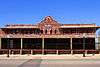
| 31 |
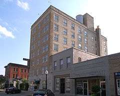
La Salle Hotel |
|
000000002000-05-26-0000May 26, 2000
(#00000555) |
120 S. Main St.
30°40′23″N 96°22′25″W / 30.673056°N 96.373611°W / 30.673056; -96.373611 (La Salle Hotel) |
Bryan |
|
| 32 |
McDougal-Jones House |
|
000000001987-09-25-0000September 25, 1987
(#87001637) |
600 E. 27th St.
30°40′20″N 96°22′04″W / 30.67232°N 96.36783°W / 30.67232; -96.36783 (McDougal-Jones House) |
Bryan |
|
| 33 |
Moore House |
Upload image |
000000001987-09-25-0000September 25, 1987
(#87001638) |
500 E. 25th St.
30°40′28″N 96°22′07″W / 30.67441°N 96.36862°W / 30.67441; -96.36862 (Moore House) |
Bryan |
|
| 34 |
Noto House |
Upload image |
000000001987-09-25-0000September 25, 1987
(#87001639) |
900 N. Parker Ave.
30°40′53″N 96°22′28″W / 30.68143°N 96.37437°W / 30.68143; -96.37437 (Noto House) |
Bryan |
|
| 35 |
Dr. William Holt Oliver House |
|
000000001987-09-25-0000September 25, 1987
(#87001640) |
602 W. 26th St.
30°40′28″N 96°22′43″W / 30.67456°N 96.37862°W / 30.67456; -96.37862 (Dr. William Holt Oliver House) |
Bryan |
|
| 36 |
Parker Lumber Company Complex |
|
000000001987-09-25-0000September 25, 1987
(#87001641) |
419 N. Main St.
30°40′38″N 96°22′21″W / 30.67723°N 96.37248°W / 30.67723; -96.37248 (Parker Lumber Company Complex) |
Bryan |
|
| 37 |
Milton Parker House |
|
000000001987-09-25-0000September 25, 1987
(#87001642) |
200 S. Congress St.
30°40′24″N 96°22′52″W / 30.67325°N 96.38102°W / 30.67325; -96.38102 (Milton Parker House) |
Bryan |
|
| 38 |
Saint Andrew's Episcopal Church |
|
000000001987-09-25-0000September 25, 1987
(#87001646) |
217 W. 26th St.
30°40′25″N 96°22′30″W / 30.67374°N 96.37497°W / 30.67374; -96.37497 (Saint Andrew's Episcopal Church) |
Bryan |
|
| 39 |
Saint Anthony's Catholic Church |
|
000000001987-09-25-0000September 25, 1987
(#87001647) |
306 S. Parker Ave.
30°40′16″N 96°22′32″W / 30.671111°N 96.375556°W / 30.671111; -96.375556 (Saint Anthony's Catholic Church) |
Bryan |
|
| 40 |
Sausley House |
Upload image |
000000001987-09-25-0000September 25, 1987
(#87001643) |
700 N. Washington Ave.
30°40′45″N 96°22′14″W / 30.67919°N 96.37067°W / 30.67919; -96.37067 (Sausley House) |
Bryan |
|
| 41 |
Old Sinclair Station |
Upload image |
000000001987-09-25-0000September 25, 1987
(#87001644) |
507 S. Texas Ave.
30°40′08″N 96°22′14″W / 30.66883°N 96.37050°W / 30.66883; -96.37050 (Old Sinclair Station) |
Bryan |
|
| 42 |
Smith-Barron House |
Upload image |
000000001988-06-20-0000June 20, 1988
(#87001645) |
100 S. Congress St.
30°40′27″N 96°22′51″W / 30.67424°N 96.38077°W / 30.67424; -96.38077 (Smith-Barron House) |
Bryan |
|
| 43 |
Roy C. Stone House |
|
000000001987-09-25-0000September 25, 1987
(#87001649) |
715 E. 31st St.
30°39′53″N 96°22′01″W / 30.66464°N 96.36685°W / 30.66464; -96.36685 (Roy C. Stone House) |
Bryan |
|
| 44 |
Temple Freda |
|
000000001983-09-22-0000September 22, 1983
(#83003128) |
205 S. Parker Ave.
30°40′21″N 96°22′30″W / 30.6725°N 96.375°W / 30.6725; -96.375 (Temple Freda) |
Bryan |
|
| 45 |
Minnie Zulch Zimmerman House |
Upload image |
000000001987-09-25-0000September 25, 1987
(#87001650) |
308 N. Washington Ave.
30°40′34″N 96°22′16″W / 30.67611°N 96.37105°W / 30.67611; -96.37105 (Minnie Zulch Zimmerman House) |
Bryan |
|