National Register of Historic Places listings in Butte County, California
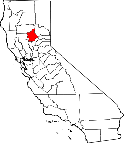
Location of Butte County in California
This is a list of the National Register of Historic Places listings in Butte County, California.
This is intended to be a complete list of the properties and districts on the National Register of Historic Places in Butte County, California, United States. Latitude and longitude coordinates are provided for many National Register properties and districts; these locations may be seen together in a Google map.[1]
There are 27 properties and districts listed on the National Register in the county.
- This National Park Service list is complete through NPS recent listings posted December 16, 2016.[2]
Current listings
| [3] | Name on the Register[4] | Image | Date listed[5] | Location | City or town | Description |
|---|---|---|---|---|---|---|
| 1 | Allen-Sommer-Gage House |  |
(#77000288) |
410 Normal St. 39°43′36″N 121°50′25″W / 39.726667°N 121.840278°W |
Chico | |
| 2 | Bidwell Mansion | 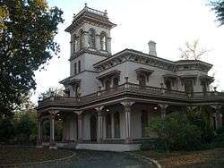 |
(#72000216) |
Sowillenno Ave. 39°43′59″N 121°50′32″W / 39.733056°N 121.842222°W |
Chico | |
| 3 | Centerville Schoolhouse | 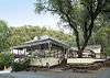 |
(#72000219) |
2 mi. NE of Paradise on Humbug Rd. 39°47′17″N 121°39′17″W / 39.788056°N 121.654722°W |
Paradise | |
| 4 | A. H. Chapman House | 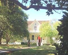 |
(#82002170) |
256 E. 12th St. 39°43′30″N 121°50′27″W / 39.725°N 121.840833°W |
Chico | |
| 5 | W. W. Durham House | 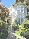 |
(#92000316) |
2280 Durham-Dayton Rd. 39°38′48″N 121°47′36″W / 39.646667°N 121.793333°W |
Durham | |
| 6 | Forks of Butte | Upload image | (#03001357) |
Travel northeast on State Highway 32 from Chico, 20 miles to Forest Ranch, then southeast on Doe Mill Road (graded dirt road), three and one-half miles to Butte Creek trailhead. Coordinates missing |
Paradise | |
| 7 | Gianella Bridge | .jpg) |
(#82004614) |
CA 32 39°45′04″N 121°59′46″W / 39.751111°N 121.996111°W |
Hamilton City | Demolished in 1987.[6] |
| 8 | Hazel Hotel | 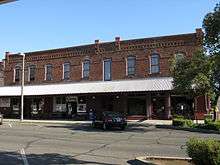 |
(#01000705) |
850, 860, 880, 890 Hazel St., and 602,608, 620 Kentuckey 39°21′54″N 121°41′43″W / 39.365°N 121.695278°W |
Gridley | |
| 9 | Honey Run Covered Bridge |  |
(#88000920) |
Honey Run Humbug Rd. 39°43′44″N 121°42′09″W / 39.728889°N 121.7025°W |
Chico | |
| 10 | Inskip Hotel | 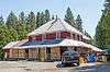 |
(#75000425) |
6 mi. N of Stirling on Skyway (Old Humbug Rd.) 39°59′25″N 121°32′29″W / 39.990361°N 121.541389°W |
Stirling City | |
| 11 | Fong Lee Company | Upload image | (#82002173) |
1500 Broderick Street Coordinates missing |
Oroville | |
| 12 | Magalia Community Church | 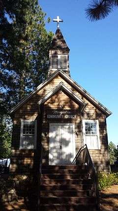 |
(#82002172) |
Stirling Hwy. 39°48′36″N 121°34′40″W / 39.81°N 121.577778°W |
Magalia | |
| 13 | Mud Creek Canyon | Upload image | (#73000396) |
Address Restricted |
Chico | |
| 14 | Oroville Carnegie Library | 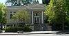 |
(#07000405) |
1675 Montgomery St. 39°30′46″N 121°33′32″W / 39.512724°N 121.558904°W |
Oroville | Now the Butte County Public Law Library[7] |
| 15 | Oroville Chinese Temple | 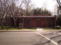 |
(#76000478) |
1500 Broderick St. 39°30′49″N 121°33′39″W / 39.513611°N 121.560833°W |
Oroville | |
| 16 | Oroville Commercial District (old) | |
(#83001174) |
Montgomery, Myers and Huntoon Sts. and Miner Alley 39°30′50″N 121°33′19″W / 39.513889°N 121.555278°W |
Oroville | |
| 17 | Oroville Inn | |
(#90001431) |
2066 Bird St. 39°30′49″N 121°33′16″W / 39.513641°N 121.55454°W |
Oroville | |
| 18 | Patrick Ranch House |  |
(#72000217) |
3 mi. SE of Chico off U.S. 99E 39°40′55″N 121°48′00″W / 39.681944°N 121.8°W |
Chico | |
| 19 | Patrick Rancheria | Upload image | (#72000218) |
Address Restricted |
Chico | |
| 20 | Silberstein Park Building | 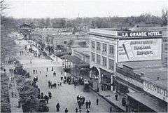 |
(#83001175) |
426, 430, 434 Broadway 39°43′41″N 121°50′17″W / 39.728056°N 121.838056°W |
Chico | Downtown building designed by A.J. Byron, and used as a movie theater, The Lyric, and La Grande Hotel. |
| 21 | South Campus Neighborhood | 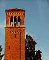 |
(#91000636) |
Bounded by W. 2nd, Normal, W. 6th and Cherry Sts. 39°43′34″N 121°50′30″W / 39.726111°N 121.841667°W |
Chico | |
| 22 | Southern Pacific Depot | 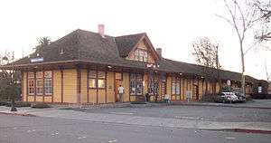 |
(#87000001) |
430 Orange St. 39°43′24″N 121°50′42″W / 39.723333°N 121.845°W |
Chico | |
| 23 | St. John's Episcopal Church | Upload image | (#82002171) |
230 Salem St. 39°43′44″N 121°50′25″W / 39.728889°N 121.840278°W |
Chico | |
| 24 | Stansbury House |  |
(#75000424) |
307 W. 5th St. 39°43′37″N 121°50′19″W / 39.726944°N 121.838611°W |
Chico | |
| 25 | State Theatre |  |
(#91001383) |
1489 Myers St. 39°30′45″N 121°33′16″W / 39.512592°N 121.554489°W |
Oroville | |
| 26 | US Post Office-Chico Midtown Station |  |
(#85000122) |
141 W. 5th St. 39°43′39″N 121°50′16″W / 39.7275°N 121.837778°W |
Chico | |
| 27 | US Post Office-Oroville Main |  |
(#85000123) |
1735 Robinson St. 39°30′40″N 121°33′27″W / 39.511174°N 121.55738°W |
Oroville |
See also
| Wikimedia Commons has media related to National Register of Historic Places in Butte County, California. |
- List of National Historic Landmarks in California
- National Register of Historic Places listings in California
- California Historical Landmarks in Butte County, California
References
- ↑ The latitude and longitude information provided in this table was derived originally from the National Register Information System, which has been found to be fairly accurate for about 99% of listings. For about 1% of NRIS original coordinates, experience has shown that one or both coordinates are typos or otherwise extremely far off; some corrections may have been made. A more subtle problem causes many locations to be off by up to 150 yards, depending on location in the country: most NRIS coordinates were derived from tracing out latitude and longitudes off of USGS topographical quadrant maps created under the North American Datum of 1927, which differs from the current, highly accurate WGS84 GPS system used by most on-line maps. Chicago is about right, but NRIS longitudes in Washington are higher by about 4.5 seconds, and are lower by about 2.0 seconds in Maine. Latitudes differ by about 1.0 second in Florida. Some locations in this table may have been corrected to current GPS standards.
- ↑ "National Register of Historic Places: Weekly List Actions". National Park Service, United States Department of the Interior. Retrieved on December 16, 2016.
- ↑ Numbers represent an ordering by significant words. Various colorings, defined here, differentiate National Historic Landmarks and historic districts from other NRHP buildings, structures, sites or objects.
- ↑ National Park Service (2010-07-09). "National Register Information System". National Register of Historic Places. National Park Service.
- ↑ The eight-digit number below each date is the number assigned to each location in the National Register Information System database, which can be viewed by clicking the number.
- ↑ http://www.orovillemr.com/news/ci_18659398
- ↑ "Butte County Public Law Library". Retrieved 2014-08-22.
| Topics | |
|---|---|
| Lists by states |
|
| Lists by insular areas | |
| Lists by associated states | |
| Other areas | |
| |
This article is issued from Wikipedia - version of the 2/27/2016. The text is available under the Creative Commons Attribution/Share Alike but additional terms may apply for the media files.