National Register of Historic Places listings in Calumet County, Wisconsin
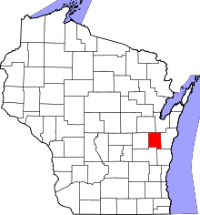
Location of Calumet County in Wisconsin
This is a list of the National Register of Historic Places listings in Calumet County, Wisconsin. It is intended to provide a comprehensive listing of entries in the National Register of Historic Places that are located in Calumet County, Wisconsin. The locations of National Register properties for which the latitude and longitude coordinates are included below may be seen in a map.[1]
There are 10 properties and districts listed on the National Register in the county.
- This National Park Service list is complete through NPS recent listings posted December 2, 2016.[2]
Current listings
| [3] | Name on the Register[4] | Image | Date listed[5] | Location | City or town | Description |
|---|---|---|---|---|---|---|
| 1 | Aebischer Site (47CT30) |  |
(#85003136) |
Address Restricted |
Chilton | Four archaeological sites ranging from 9000 BC to 1900 AD, located within the Killsnake Wildlife Area, including a Paleo-Indian site which has produced Clovis-like fluted points.[6] |
| 2 | Calumet County Courthouse | 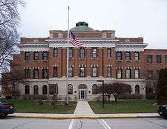 |
(#82000640) |
206 Court St. 44°01′48″N 88°10′06″W / 44.03°N 88.168333°W |
Chilton | Neoclassical courthouse with center dome, built in 1913 and designed by B. Mehner, who designed the similar Taylor County Courthouse.[7] |
| 3 | Calumet County Park Group |  |
(#97001551) |
N6150 CTH EE Coordinates missing |
Hilbert | Six effigy mounds of panthers or water spirits, on the escarpment overlooking Lake Winnebago.[8] |
| 4 | Chilton Post Office | 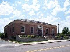 |
(#00001249) |
57 E. Main St. 44°01′45″N 88°09′41″W / 44.029167°N 88.161389°W |
Chilton | Red-brick Georgian Revival building built by the Public Works Administration in 1938, containing a 1940 mural by Charles W. Thwaites: "Threshing Barley."[9][10] |
| 5 | Haese Memorial Village Historic District |  |
(#82000641) |
Milwaukee and Randolph Sts 44°12′28″N 88°08′32″W / 44.207778°N 88.142222°W |
Forest Junction | Remnant business district of a town that formed where two railroads crossed, then withered as logging faded, as the automobile replaced the train, and as Appleton grew.[11] Structures include the 1884 Haese General Store (pictured),[12] the 1908 Hunt hardware store, a summer kitchen,[13] and the 1908 Haese gas station. |
| 6 | High Cliff Mounds | |
(#96001629) |
Address Restricted |
Sherwood | Effigy mound group on the escarpment at High Cliff State Park, including panther mounds, conical and linear.[14] |
| 7 | Ridge Group | |
(#78000079) |
Address Restricted |
Brothertown | Collection of mounds, enclosures & burial grounds built by Woodland people.[15] |
| 8 | Stockbridge Harbor | 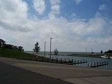 |
(#98001089) |
Address Restricted |
Stockbridge | Site of a palisaded village, possibly built around 1100 CE by a mix of effigy mound and Late Woodland people.[16] |
| 9 | Stockbridge Indian Cemetery | 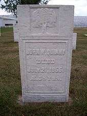 |
(#80000111) |
N of Stockbridge off WI 55 44°04′56″N 88°18′03″W / 44.082222°N 88.300833°W |
Stockbridge | Small burial ground of a farming community of Stockbridge Indians from around the 1820s to 1856, since moved to Shawano County. Burials include John Quinney.[17] |
| 10 | Herman C. Timm House |  |
(#96000727) |
1600 Main St. 43°57′00″N 88°05′08″W / 43.95°N 88.085556°W |
New Holstein | The initial modest house built in 1872 was expanded and remodeled in a grand Stick style in 1892. Timm was a German immigrant who built a grain elevator in New Holstein, served as village president, and founded the State Bank. Now a museum.[18][19] |
See also
- List of National Historic Landmarks in Wisconsin
- National Register of Historic Places listings in Wisconsin
References
- ↑ The latitude and longitude information provided is primarily from the National Register Information System, and has been found to be fairly accurate for about 99% of listings. For 1%, the location info may be way off. We seek to correct the coordinate information wherever it is found to be erroneous. Please leave a note in the Discussion page for this article if you believe any specific location is incorrect.
- ↑ "National Register of Historic Places: Weekly List Actions". National Park Service, United States Department of the Interior. Retrieved on December 2, 2016.
- ↑ Numbers represent an ordering by significant words. Various colorings, defined here, differentiate National Historic Landmarks and historic districts from other NRHP buildings, structures, sites or objects.
- ↑ National Park Service (2008-04-24). "National Register Information System". National Register of Historic Places. National Park Service.
- ↑ The eight-digit number below each date is the number assigned to each location in the National Register Information System database, which can be viewed by clicking the number.
- ↑ Kreisa, Paul P. (1987-01-01). "The Paleo-Indian Tradition in Wisconsin" (PDF). NRHP Multiple Property Documentation Form. National Park Service. Retrieved 2015-12-22.
- ↑ Filipowicz, D. (October 1981). "Calumet County Courthouse" (PDF). NRHP Inventory-Nomination Form. National Park Service. Retrieved 2015-12-26.
- ↑ Birmingham, Robert A.; Eisenberg, Leslie E. (2000). Indian Mounds of Wisconsin. Madison: University of Wisconsin Press. p. 194. ISBN 0-299-16874-3.
- ↑ Causier, Charles E.; Jurkiewicz, Joseph G. (1993-12-29). "Chilton Post Office" (PDF). NRHP Inventory-Nomination Form. National Park Service. Retrieved 2015-12-26.
- ↑ "Chilton Post Office". Wisconsin Historical Society. Retrieved 2015-12-26.
- ↑ Matucheski, Michael R. (1980-06-10). "Haese Memorial Village Historic District" (PDF). NRHP Inventory-Nomination Form. National Park Service. Retrieved 2015-12-29.
- ↑ "F G Haese General Merchandise Store (A)". Wisconsin Historical Society. Retrieved 2015-12-29.
- ↑ "SE Cnr Milwaukee St and Randolph St". Wisconsin Historical Society. Retrieved 2015-12-29.
- ↑ Birmingham, Robert A.; Eisenberg, Leslie E. (2000). Indian Mounds of Wisconsin. Madison: University of Wisconsin Press. p. 194. ISBN 0-299-16874-3.
- ↑ Foth Infrastructure & Environment, LLC. "Town of Brothertown - Expanded Land Use Element". Retrieved 2015-12-29.
- ↑ Stockbridge Harbor Historical Marker.
- ↑ Shoptaugh, Terry L. (1980-03-02). "Stockbridge Indian Cemetery" (PDF). NRHP Inventory-Nomination Form. National Park Service. Retrieved 2016-01-06.
- ↑ "Timm, Herman C., House". Wisconsin Historical Society. Retrieved 2016-01-06.
- ↑ Adams, Peter J. (1995-02-08). "Timm, Herman C., House" (PDF). NRHP Inventory-Nomination Form. National Park Service. Retrieved 2016-01-06.
Municipalities and communities of Calumet County, Wisconsin, United States | ||
|---|---|---|
| Cities | | |
| Villages | ||
| Towns | ||
| CDP | ||
| Unincorporated communities | ||
| Ghost town | ||
| Footnotes | ‡This populated place also has portions in an adjacent county or counties | |
| Topics | |
|---|---|
| Lists by states |
|
| Lists by insular areas | |
| Lists by associated states | |
| Other areas | |
| |
| Wikimedia Commons has media related to National Register of Historic Places in Calumet County, Wisconsin. |
This article is issued from Wikipedia - version of the 5/15/2016. The text is available under the Creative Commons Attribution/Share Alike but additional terms may apply for the media files.