| [2] |
Name on the Register |
Image |
Date listed[3] |
Location |
City or town |
Description |
|---|
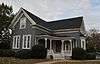
| 1 |
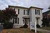
Dr. Robert Battey House |
|
000000001982-06-17-0000June 17, 1982
(#82002414) |
725 E. 2nd Ave.
34°14′35″N 85°09′54″W / 34.243056°N 85.165°W / 34.243056; -85.165 (Dr. Robert Battey House) |
Rome |
|
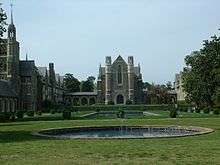
| 2 |
Berry Schools |
|
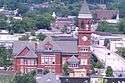
000000001978-07-21-0000July 21, 1978
(#78000981) |
N of Rome on U.S. 27
34°18′27″N 85°12′49″W / 34.3075°N 85.213611°W / 34.3075; -85.213611 (Berry Schools) |
Rome |
|
| 3 |
Between the Rivers Historic District |
|
000000001983-06-09-0000June 9, 1983
(#83000193) |
Roughly bounded by the Etowah and Oostanaula Rivers, and 7th Ave.
34°15′06″N 85°10′16″W / 34.251667°N 85.171111°W / 34.251667; -85.171111 (Between the Rivers Historic District) |
Rome |
|
| 4 |
John M. Carroll House |
Upload image |
000000001980-06-19-0000June 19, 1980
(#80001021) |
Park St.
34°06′09″N 85°20′23″W / 34.1025°N 85.339722°W / 34.1025; -85.339722 (John M. Carroll House) |
Cave Spring |
|
| 5 |
Carroll-Harper House |
Upload image |
000000001980-06-19-0000June 19, 1980
(#80001023) |
Cedartown St.
34°06′13″N 85°20′10″W / 34.103611°N 85.336111°W / 34.103611; -85.336111 (Carroll-Harper House) |
Cave Spring |
|
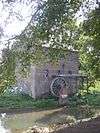
| 6 |
Carroll-Richardson Grist Mill |
Upload image |
000000001980-06-19-0000June 19, 1980
(#80001025) |
Mill St.
34°06′04″N 85°20′27″W / 34.101111°N 85.340833°W / 34.101111; -85.340833 (Carroll-Richardson Grist Mill) |
Cave Spring |
|
| 7 |
Cave Spring Commercial Historic District |
|
000000001980-06-19-0000June 19, 1980
(#80001028) |
Alabama, Rome and Cedartown Rds., Broad and Padlock Sts.
34°06′27″N 85°20′11″W / 34.1075°N 85.336389°W / 34.1075; -85.336389 (Cave Spring Commercial Historic District) |
Cave Spring |
|
| 8 |
Cave Spring Female Academy |
Upload image |
000000001980-06-19-0000June 19, 1980
(#80001030) |
Rome St.
34°06′43″N 85°19′59″W / 34.111944°N 85.333056°W / 34.111944; -85.333056 (Cave Spring Female Academy) |
Cave Spring |
|
| 9 |
Cave Spring High School |
Upload image |
000000001980-06-19-0000June 19, 1980
(#80001032) |
Rome St.
34°06′37″N 85°20′07″W / 34.110278°N 85.335278°W / 34.110278; -85.335278 (Cave Spring High School) |
Cave Spring |
|
| 10 |
Cave Spring Railroad Station |
|
000000001980-06-19-0000June 19, 1980
(#80001034) |
Alabama St.
34°06′28″N 85°20′32″W / 34.107778°N 85.342222°W / 34.107778; -85.342222 (Cave Spring Railroad Station) |
Cave Spring |
|
| 11 |
Cave Spring Residential Historic District |
Upload image |
000000001980-06-19-0000June 19, 1980
(#80001035) |
U.S. 411 and GA 100
34°06′29″N 85°20′22″W / 34.108056°N 85.339444°W / 34.108056; -85.339444 (Cave Spring Residential Historic District) |
Cave Spring |
|
| 12 |
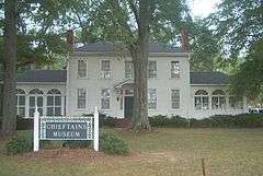
Chieftains |
|
000000001971-04-07-0000April 7, 1971
(#71000273) |
80 Chatillon Rd.
34°16′38″N 85°10′13″W / 34.27710°N 85.17019°W / 34.27710; -85.17019 (Chieftains) |
Rome |
National Historic Landmark
|
| 13 |
Chubb Methodist Episcopal Church |
Upload image |
000000001990-05-04-0000May 4, 1990
(#90000728) |
Chubbtown Rd.
34°05′12″N 85°16′59″W / 34.086667°N 85.283056°W / 34.086667; -85.283056 (Chubb Methodist Episcopal Church) |
Cave Spring |
|
| 14 |
Wesley O. Conner House |
Upload image |
000000001980-06-19-0000June 19, 1980
(#80001037) |
Cedartown St.
34°06′00″N 85°19′51″W / 34.1°N 85.330833°W / 34.1; -85.330833 (Wesley O. Conner House) |
Cave Spring |
|
| 15 |
William D. Cowdry Plantation |
Upload image |
000000001980-06-19-0000June 19, 1980
(#80001039) |
Rome Rd.
34°07′01″N 85°20′10″W / 34.116944°N 85.336111°W / 34.116944; -85.336111 (William D. Cowdry Plantation) |
Cave Spring |
|
| 16 |
Double-Cola Bottling Company |
|
000000002006-08-30-0000August 30, 2006
(#06000738) |
419 E. Second Ave.
34°14′52″N 85°10′10″W / 34.247778°N 85.169444°W / 34.247778; -85.169444 (Double-Cola Bottling Company) |
Rome |
|
| 17 |
East Rome Historic District |
Upload image |
000000001985-07-25-0000July 25, 1985
(#85001637) |
Roughly bounded by Walnut Ave., McCall Blvd., E. 8th and 10th Sts.
34°14′30″N 85°09′53″W / 34.241667°N 85.164722°W / 34.241667; -85.164722 (East Rome Historic District) |
Rome |
|
| 18 |
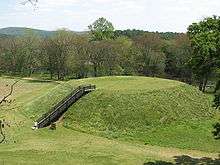
Etowah Mounds |
|
000000001966-10-15-0000October 15, 1966
(#66000272) |
N bank of Etowah River
34°07′33″N 84°48′29″W / 34.125833°N 84.808056°W / 34.125833; -84.808056 (Etowah Mounds) |
Rome |
|
| 19 |
Oliver P. Fannin House |
Upload image |
000000001980-06-19-0000June 19, 1980
(#80001041) |
Cedartown St.
34°06′16″N 85°20′13″W / 34.104444°N 85.336944°W / 34.104444; -85.336944 (Oliver P. Fannin House) |
Cave Spring |
|
| 20 |
Floyd County Courthouse |
|
000000001980-09-18-0000September 18, 1980
(#80001067) |
5th Ave., and Tribune St.
34°15′22″N 85°10′17″W / 34.256111°N 85.171389°W / 34.256111; -85.171389 (Floyd County Courthouse) |
Rome |
|
| 21 |
Joseph Ford House |
Upload image |
000000001980-06-19-0000June 19, 1980
(#80001043) |
Love and Alabama Sts.
34°06′23″N 85°20′12″W / 34.106389°N 85.336667°W / 34.106389; -85.336667 (Joseph Ford House) |
Cave Spring |
|
| 22 |
Georgia School for the Deaf Historic District |
Upload image |
000000001980-06-19-0000June 19, 1980
(#80001045) |
Padlock St.
34°06′27″N 85°20′00″W / 34.1075°N 85.333333°W / 34.1075; -85.333333 (Georgia School for the Deaf Historic District) |
Cave Spring |
|
| 23 |
Jackson Hill Historic District |
Upload image |
000000001997-04-25-0000April 25, 1997
(#97000370) |
Jackson Hill, between GA 53 and the Oostanaula River
34°15′51″N 85°09′52″W / 34.264167°N 85.164444°W / 34.264167; -85.164444 (Jackson Hill Historic District) |
Rome |
|
| 24 |
Lower Avenue A Historic District |
Upload image |
000000001983-09-01-0000September 1, 1983
(#83000194) |
Avenue A between N. 5th St. and Turner-McCall Blvd.
34°15′33″N 85°10′24″W / 34.259167°N 85.173333°W / 34.259167; -85.173333 (Lower Avenue A Historic District) |
Rome |
|
| 25 |
Main High School |
Upload image |
000000002002-10-24-0000October 24, 2002
(#02001219) |
41 Washington Dr.
34°15′27″N 85°09′15″W / 34.2575°N 85.154167°W / 34.2575; -85.154167 (Main High School) |
Rome |
|
| 26 |
John T. Mann House |
Upload image |
000000001980-06-19-0000June 19, 1980
(#80001047) |
Rivers St.
34°06′33″N 85°20′12″W / 34.109167°N 85.336667°W / 34.109167; -85.336667 (John T. Mann House) |
Cave Spring |
|
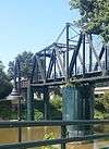
| 27 |
Mayo's Bar Lock and Dam |
Upload image |
000000001989-11-16-0000November 16, 1989
(#89002020) |
On the Coosa River, 8 mi. SW of Rome
34°12′02″N 85°15′21″W / 34.200556°N 85.255833°W / 34.200556; -85.255833 (Mayo's Bar Lock and Dam) |
Rome |
|
| 28 |
Dr. W. T. McKinney House |
Upload image |
000000001980-06-19-0000June 19, 1980
(#80001049) |
Cedartown St.
34°05′59″N 85°20′19″W / 34.099722°N 85.338611°W / 34.099722; -85.338611 (Dr. W. T. McKinney House) |
Cave Spring |
|
| 29 |
Mt. Aventine Historic District |
Upload image |
000000001983-08-18-0000August 18, 1983
(#83000195) |
Address Restricted
|
Rome |
|
| 30 |
Myrtle Hill Cemetery |
|
000000001983-09-01-0000September 1, 1983
(#83000196) |
Bounded by S. Broad, and Myrtle Sts., Pennington, and Branham Aves.
34°15′07″N 85°10′46″W / 34.251944°N 85.179444°W / 34.251944; -85.179444 (Myrtle Hill Cemetery) |
Rome |
|
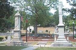
| 31 |
Oakdene Place |
Upload image |
000000001983-08-04-0000August 4, 1983
(#83000197) |
Roughly bounded by the Etowah River, Queen, and E. 6th Sts.
34°14′38″N 85°10′08″W / 34.243889°N 85.168889°W / 34.243889; -85.168889 (Oakdene Place) |
Rome |
|
| 32 |
Old Brick Mill |
|
000000001993-09-09-0000September 9, 1993
(#93000936) |
Park St. at Silver Cr.
34°11′19″N 85°10′28″W / 34.188611°N 85.174444°W / 34.188611; -85.174444 (Old Brick Mill) |
Lindale |
|
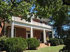
| 33 |
Rivers Farm |
Upload image |
000000001980-06-19-0000June 19, 1980
(#80001051) |
Rome St.
34°07′00″N 85°20′13″W / 34.116667°N 85.336944°W / 34.116667; -85.336944 (Rivers Farm) |
Cave Spring |
|
| 34 |
Samuel W. Robbins House |
Upload image |
000000001980-06-19-0000June 19, 1980
(#80001053) |
Rome St.
34°06′30″N 85°20′10″W / 34.108333°N 85.336111°W / 34.108333; -85.336111 (Samuel W. Robbins House) |
Cave Spring |
|
| 35 |
Rolator Park Historic District |
Upload image |
000000001980-06-19-0000June 19, 1980
(#80001055) |
Off U.S. 411
34°06′16″N 85°20′07″W / 34.104444°N 85.335278°W / 34.104444; -85.335278 (Rolator Park Historic District) |
Cave Spring |
|
| 36 |
Rome Clock Tower |
|
000000001980-02-08-0000February 8, 1980
(#80001068) |
Off GA 101
34°15′13″N 85°10′09″W / 34.253611°N 85.169167°W / 34.253611; -85.169167 (Rome Clock Tower) |
Rome |
|
| 37 |
Roving House |
Upload image |
000000001980-06-19-0000June 19, 1980
(#80001057) |
Rome St.
34°06′39″N 85°19′49″W / 34.110833°N 85.330278°W / 34.110833; -85.330278 (Roving House) |
Cave Spring |
|
| 38 |
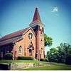
Sardis Presbyterian Church and Cemetery |
Upload image |
000000002005-01-12-0000January 12, 2005
(#04001468) |
7104 GA 20 NW
34°15′55″N 85°22′41″W / 34.265278°N 85.378056°W / 34.265278; -85.378056 (Sardis Presbyterian Church and Cemetery) |
Coosa |
|
| 39 |
Simmons House |
|
000000001980-06-19-0000June 19, 1980
(#80001059) |
Cedartown St.
34°05′57″N 85°19′59″W / 34.099167°N 85.333056°W / 34.099167; -85.333056 (Simmons House) |
Cave Spring |
|
| 40 |
William S. Simmons Plantation |
Upload image |
000000001980-06-19-0000June 19, 1980
(#80001061) |
Alabama St.
34°06′03″N 85°20′41″W / 34.100833°N 85.344722°W / 34.100833; -85.344722 (William S. Simmons Plantation) |
Cave Spring |
|
| 41 |
South Broad Street Historic District |
Upload image |
000000001983-08-18-0000August 18, 1983
(#83004182) |
S. Broad St. and Etowah Terrace
34°14′57″N 85°10′40″W / 34.249167°N 85.177778°W / 34.249167; -85.177778 (South Broad Street Historic District) |
Rome |
|
| 42 |
Sullivan-Hillyer House |
|
000000002002-10-21-0000October 21, 2002
(#02001215) |
309 E. Second Ave.
34°15′00″N 85°10′17″W / 34.25°N 85.171389°W / 34.25; -85.171389 (Sullivan-Hillyer House) |
Rome |
|
| 43 |
Thankful Baptist Church |
|
000000001985-09-05-0000September 5, 1985
(#85001973) |
935 Spiderwebb Dr.
34°15′28″N 85°09′36″W / 34.257778°N 85.16°W / 34.257778; -85.16 (Thankful Baptist Church) |
Rome |
|
| 44 |
U.S. Post Office and Courthouse |
|
000000001975-05-06-0000May 6, 1975
(#75000592) |
W. 4th Ave. and E. 1st St.
34°15′14″N 85°10′15″W / 34.253889°N 85.170833°W / 34.253889; -85.170833 (U.S. Post Office and Courthouse) |
Rome |
|
| 45 |
Upper Avenue A Historic District |
Upload image |
000000001983-09-01-0000September 1, 1983
(#83000198) |
Roughly bounded by Oostanaula River, Turner-McCall Blvd., Avenue B and W. 11th St.
34°15′45″N 85°10′27″W / 34.2625°N 85.174167°W / 34.2625; -85.174167 (Upper Avenue A Historic District) |
Rome |
|
| 46 |
George T. Watts House |
Upload image |
000000001980-06-19-0000June 19, 1980
(#80001063) |
Love St.
34°06′22″N 85°20′24″W / 34.106111°N 85.34°W / 34.106111; -85.34 (George T. Watts House) |
Cave Spring |
|
| 47 |
Wharton-Trout House |
Upload image |
000000001980-06-19-0000June 19, 1980
(#80001065) |
Rome St.
34°06′53″N 85°19′44″W / 34.114722°N 85.328889°W / 34.114722; -85.328889 (Wharton-Trout House) |
Cave Spring |
|