National Register of Historic Places listings in Goliad County, Texas
This is intended to be a complete list of properties and districts listed on the National Register of Historic Places in Goliad County, Texas. The locations of National Register properties and districts (at least for all showing latitude and longitude coordinates below) may be seen in a map by clicking on "Map of all coordinates".[1]
- This National Park Service list is complete through NPS recent listings posted December 2, 2016.[2]
| [3] | Name on the Register[4] | Image | Date listed[5] | Location | City or town | Description |
|---|---|---|---|---|---|---|
| 1 | Charles H. and Catherine B. Baker House | 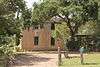 |
(#85001616) |
401 S. Commercial St. 28°39′52″N 97°23′35″W / 28.66436°N 97.39309°W |
Goliad | |
| 2 | Dr. L.W. and Martha E.S. Chilton House | 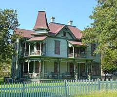 |
(#98000354) |
242 N. Chilton St. 28°40′13″N 97°23′39″W / 28.67031°N 97.39424°W |
Goliad | |
| 3 | Fair Oaks Ranch | Upload image | (#07000127) |
14509 US 59 S 28°31′40″N 97°32′55″W / 28.5277°N 97.5485°W |
Berclair | |
| 4 | Goliad County Courthouse Historic District |  |
(#76002034) |
Roughly bounded by E. Franklin, S. Washington, E. Fannin, and S. Chilton Sts. 28°39′57″N 97°23′31″W / 28.665833°N 97.391944°W |
Goliad | |
| 5 | Goliad State Park Historic District | Upload image | (#01000258) |
US 183 at San Antonio River 28°39′18″N 97°23′14″W / 28.65506°N 97.38715°W |
Goliad | |
| 6 | Nuestra Senora del Espiritu Santo de Zuniga Site | 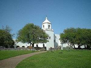 |
(#77001446) |
US 183 at San Antonio River 28°39′26″N 97°23′12″W / 28.65714°N 97.38671°W |
Goliad | |
| 7 | Old Market House Museum | 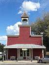 |
(#72001362) |
S. Market and Franklin Sts. 28°40′01″N 97°23′28″W / 28.66690°N 97.39104°W |
Goliad | |
| 8 | Capt. Barton Peck House | 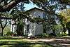 |
(#79002947) |
W of Goliad at Hill and Post Oak St. 28°39′59″N 97°24′05″W / 28.666389°N 97.401389°W |
Goliad | |
| 9 | Presidio Nuestra Senora De Loreto De La Bahia | 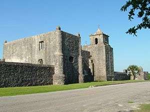 |
(#67000024) |
1 mi (1.6 km). S of Goliad State Park on U.S. 183 28°38′51″N 97°22′57″W / 28.6475°N 97.3825°W |
Goliad | |
| 10 | Ruins of Mission Nuestra Senora del Rosario de los Cujanes | Upload image | (#72001363) |
Address Restricted |
Goliad | |
| 11 | San Antonio River Valley (West of Goliad) Rural Historic District | Upload image | (#95001453) |
28°38′52″N 97°28′42″W / 28.6479°N 97.4783°W |
Goliad | |
| 12 | Jessie W. Stoddard House | 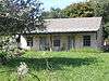 |
(#91002020) |
Jct. of US 183, Fannin and Hord Sts. 28°39′54″N 97°23′18″W / 28.66505°N 97.38845°W |
Goliad |
See also
| Wikimedia Commons has media related to National Register of Historic Places in Goliad County, Texas. |
References
- ↑ The latitude and longitude information provided in this table was derived originally from the National Register Information System, which has been found to be fairly accurate for about 99% of listings. For about 1% of NRIS original coordinates, experience has shown that one or both coordinates are typos or otherwise extremely far off; some corrections may have been made. A more subtle problem causes many locations to be off by up to 150 yards, depending on location in the country: most NRIS coordinates were derived from tracing out latitude and longitudes off of USGS topographical quadrant maps created under the North American Datum of 1927, which differs from the current, highly accurate WGS84 GPS system used by most on-line maps. Chicago is about right, but NRIS longitudes in Washington are higher by about 4.5 seconds, and are lower by about 2.0 seconds in Maine. Latitudes differ by about 1.0 second in Florida. Some locations in this table may have been corrected to current GPS standards.
- ↑ "National Register of Historic Places: Weekly List Actions". National Park Service, United States Department of the Interior. Retrieved on December 2, 2016.
- ↑ Numbers represent an ordering by significant words. Various colorings, defined here, differentiate National Historic Landmarks and historic districts from other NRHP buildings, structures, sites or objects.
- ↑ National Park Service (2008-04-24). "National Register Information System". National Register of Historic Places. National Park Service.
- ↑ The eight-digit number below each date is the number assigned to each location in the National Register Information System database, which can be viewed by clicking the number.
| Topics | |
|---|---|
| Lists by states |
|
| Lists by insular areas | |
| Lists by associated states | |
| Other areas | |
| |
This article is issued from Wikipedia - version of the 7/2/2016. The text is available under the Creative Commons Attribution/Share Alike but additional terms may apply for the media files.