National Register of Historic Places listings in Grand Teton National Park
This is a list of the National Register of Historic Places listings in Grand Teton National Park.
This is intended to be a complete list of the properties and districts on the National Register of Historic Places in Grand Teton National Park, Wyoming, United States. The locations of National Register properties and districts for which the latitude and longitude coordinates are included below, may be seen in a Google map.[1]
There are 36 properties and districts listed on the National Register in the park, two of which are National Historic Landmarks.
- This National Park Service list is complete through NPS recent listings posted December 2, 2016.[2]
Current listings
| [3] | Name on the Register | Image | Date listed[4] | Location | City or town | Description |
|---|---|---|---|---|---|---|
| 1 | 4 Lazy F Dude Ranch | 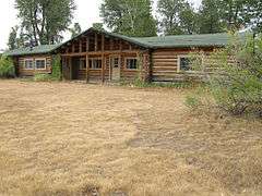 |
(#90000611) |
Off Teton Park Rd. 43°40′03″N 110°42′27″W / 43.6675°N 110.7075°W |
Moose | Summer residence and dude ranch, also known as Sun Star Ranch |
| 2 | AMK Ranch | 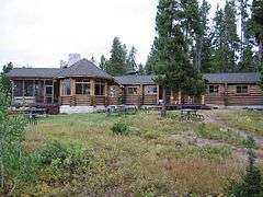 |
(#90000615) |
Off U.S. Routes 27/89 43°56′20″N 110°38′30″W / 43.938889°N 110.641667°W |
Moran | Summer residence and dude ranch |
| 3 | Bar B C Dude Ranch |  |
(#90000624) |
Off Teton Park Rd. 43°41′42″N 110°41′42″W / 43.695°N 110.695°W |
Moose | One of the first and largest dude ranches in Jackson Hole |
| 4 | The Brinkerhoff |  |
(#90000622) |
Teton Park Rd. 43°51′03″N 110°35′35″W / 43.850833°N 110.593056°W |
Moose | Summer residence, used as a presidential retreat |
| 5 | Cascade Canyon Barn |  |
(#98001023) |
Cascade Canyon 5 miles upstream from Jenny Lake 43°46′05″N 110°49′22″W / 43.768056°N 110.822778°W |
Moose | Backcountry ranger patrol cabin and barn |
| 6 | Andy Chambers Ranch Historic District | 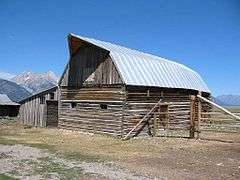 |
(#90000623) |
Mormon Row east of Moose 43°39′29″N 110°39′41″W / 43.658056°N 110.661389°W |
Moose | Nearly complete family homestead in Jackson Hole |
| 7 | Chapel of the Transfiguration | 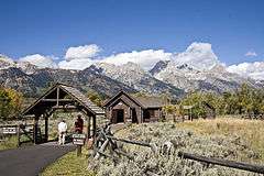 |
(#80004055) |
Grand Teton National Park 43°39′37″N 110°42′52″W / 43.660278°N 110.714444°W |
Moose | Chapel built around a view of the Cathedral Group of Teton peaks |
| 8 | Cunningham Cabin | |
(#73000225) |
Northeast of Moose off U.S. Routes 26/89/187 in Grand Teton National Park 43°46′44″N 110°33′28″W / 43.778889°N 110.557778°W |
Moose | Early Jackson Hole homestead cabin |
| 9 | Death Canyon Barn |  |
(#98001024) |
5 miles northwest of Phelps Lake near Alaska Basin 43°39′53″N 110°49′45″W / 43.664722°N 110.829167°W |
Moose | Backcountry ranger patrol cabin and barn |
| 10 | Double Diamond Dude Ranch Dining Hall | 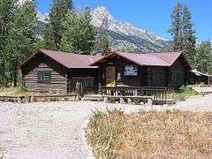 |
(#98001028) |
5 miles north of Moose, western side of Teton Park Rd. and Cottonwood Creek 43°42′07″N 110°44′05″W / 43.701944°N 110.734722°W |
Moose | Dude ranch lodge |
| 11 | Highlands Historic District |  |
(#98001029) |
5 miles north of park headquarters, ¼ mile west of Teton Park Rd. 43°42′32″N 110°43′45″W / 43.708889°N 110.729167°W |
Moose | Former tourist camp used for NPS personnel |
| 12 | Hunter Hereford Ranch Historic District | 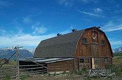 |
(#98001031) |
Southeastern corner of park, south of Shadow Mountain along Aspen Ridge 43°40′33″N 110°36′36″W / 43.6759°N 110.60989°W |
Moose | Former working ranch in Jackson Hole |
| 13 | Jackson Lake Lodge | |
(#03001039) |
Teton Park Road 43°52′50″N 110°34′32″W / 43.880556°N 110.575556°W |
Moran | Designed by Gilbert Stanley Underwood, a modernist reinterpretation of lodge architecture. National Historic Landmark. |
| 14 | Jackson Lake Ranger Station |  |
(#90000620) |
Off Teton Park Rd. 43°52′18″N 110°34′14″W / 43.871667°N 110.570556°W |
Moose | Former U.S. Forest Service ranger station transferred to the National Park Service |
| 15 | Jenny Lake Boat Concession Facilities |  |
(#98001032) |
Southern end of Jenny Lake 43°45′04″N 110°43′31″W / 43.751111°N 110.725278°W |
Moose | Park concession facility |
| 16 | Jenny Lake CCC Camp NP-4 |  |
(#98001033) |
¼ mile south of Jenny Lake on the western side of Cottonwood Creek 43°44′58″N 110°43′28″W / 43.749444°N 110.724444°W |
Moose | Only surviving Civilian Conservation Corps camp structure in the park |
| 17 | Jenny Lake Ranger Station Historic District |  |
(#90000610) |
Jenny Lake Rd. 43°45′13″N 110°43′19″W / 43.753611°N 110.721944°W |
Moose | Rustic ranger station |
| 18 | Kimmel Kabins |  |
(#90000612) |
Off Teton Park Rd. 43°44′38″N 110°43′38″W / 43.743889°N 110.727222°W |
Moose | Former tourist camp |
| 19 | Leek's Lodge |  |
(#75000216) |
10 miles northwest of Moran in Grand Teton National Park off U.S. Routes 89/287 43°55′50″N 110°38′20″W / 43.930556°N 110.638889°W |
Moran | Former tourist camp |
| 20 | Leigh Lake Ranger Patrol Cabin |  |
(#90000618) |
Off Teton Park Teton Rd. at Lehigh Lake 43°49′36″N 110°44′16″W / 43.826667°N 110.737778°W |
Moose | Backcountry ranger station |
| 21 | Geraldine Lucas Homestead-Fabian Place Historic District |  |
(#98001034) |
4.5 miles north of Moose 43°43′16″N 110°44′03″W / 43.721111°N 110.734167°W |
Moose | Former homesteader's cabin, associated in later years with the Snake River Land Company |
| 22 | Manges Cabin | 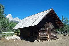 |
(#98001035) |
Southern end of park southeast of Taggart Lake 43°41′54″N 110°43′59″W / 43.698333°N 110.733056°W |
Moose | Homestead cabin that became part of a dude ranch |
| 23 | Menor's Ferry |  |
(#69000016) |
Across the Snake River just above park headquarters, Grand Teton National Park 43°39′30″N 110°42′29″W / 43.658333°N 110.708056°W |
Moose | Former ferry crossing on the Snake River operated by homesteader Bill Menor |
| 24 | Moose Entrance Kiosk | 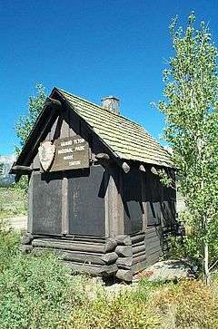 |
(#90000619) |
Teton Park Rd. 43°39′30″N 110°43′09″W / 43.658333°N 110.719167°W |
Moose | Rustic style park entrance structure |
| 25 | Moran Bay Patrol Cabin | Upload image | (#98001037) |
Northern bank of Moran Bay on Jackson Lake 43°39′53″N 110°49′45″W / 43.664722°N 110.829167°W |
Moose | Backcounty patrol cabin built by the CCC |
| 26 | Mormon Row Historic District |  |
(#97000495) |
Roughly east of U.S. Routes 26/89/187 from Antelope Flats to Grand Teton National Park-Teton National Forest border 43°39′24″N 110°37′06″W / 43.656667°N 110.618333°W |
Moose | Group of Mormon homesteads in Jackson Hole, includes the Andy Chambers Ranch and the T. A. Moulton Barn |
| 27 | Murie Ranch Historic District | 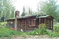 |
(#98001039) |
½ mile southwest of park headquarters 43°39′02″N 110°43′37″W / 43.650556°N 110.726944°W |
Moose | Former STS dude ranch incorporating the Murie Residence and the home of Olaus Murie's brother Adolph Murie, birthplace of the Wilderness Society. National Historic Landmark. |
| 28 | Murie Residence |  |
(#90000616) |
Off Moose Wilson Rd. 43°39′00″N 110°43′37″W / 43.65°N 110.726944°W |
Moose | Home of conservationists Olaus and Mardie Murie, part of Murie Ranch Historic District National Historic Landmark |
| 29 | Old Administrative Area Historic District | 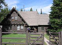 |
(#90000621) |
Off Teton Park Rd. 43°41′10″N 110°44′08″W / 43.686111°N 110.735556°W |
Moose | Former park headquarters area built by the CCC |
| 30 | Ramshorn Dude Ranch Lodge | 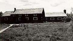 |
(#98001041) |
Southeastern corner of park, 2.5 miles northwest of Kelly 43°40′11″N 110°35′46″W / 43.669722°N 110.596111°W |
Moose | Guest ranch and climbing school now used by the Teton Science School |
| 31 | Snake River Land Company Residence and Office | 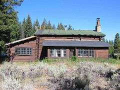 |
(#98001036) |
Western bank of the Snake River, ¼ north of Moran Junction 43°50′33″N 110°30′44″W / 43.8425°N 110.512222°W |
Moose | Guest ranch that became the headquarters for John D. Rockefeller, Jr.'s venture to buy land for the expansion of Grand Teton National Prk |
| 32 | String Lake Comfort Station |  |
(#90000617) |
Off Teton Park Rd. at String Lake 43°47′19″N 110°43′47″W / 43.788611°N 110.729722°W |
Moose | Rustic public toilet structure |
| 33 | Triangle X Barn |  |
(#98001042) |
Eastern side of park, north of Shadow Mountain 43°45′53″N 110°34′01″W / 43.764722°N 110.566944°W |
Moose | Local vernacular barn at the last dude ranch operating in the park |
| 34 | Upper Granite Canyon Patrol Cabin |  |
(#98001043) |
Southwestern corner of park at Granite Canyon, Rendezvous Pass 43°36′49″N 110°53′50″W / 43.613611°N 110.897222°W |
Moose | Backcountry patrol cabin |
| 35 | White Grass Dude Ranch |  |
(#90000613) |
Off Moose Wilson Rd. 43°39′28″N 110°46′23″W / 43.657778°N 110.773056°W |
Moose | Former dude ranch, now an architectural conservation training center |
| 36 | White Grass Ranger Station Historic District | 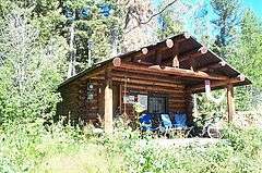 |
(#90000614) |
Off Moose Wilson Rd. 43°39′20″N 110°46′48″W / 43.655556°N 110.78°W |
Moose | Backcountry ranger station |
See also
- National Register of Historic Places listings in Teton County, Wyoming
- List of National Historic Landmarks in Wyoming
- National Register of Historic Places listings in Wyoming
References
- Culpin, Mary Shivers. National Register of Historic Places Multiple Property Documentation Form: Grand Teton National Park Multiple Property Submission. National Park Service 1995 http://focus.nps.gov/pdfhost/docs/NRHP/Text/64500741.pdf
- ↑ The latitude and longitude information provided in this table was derived originally from the National Register Information System, which has been found to be fairly accurate for about 99% of listings. For about 1% of NRIS original coordinates, experience has shown that one or both coordinates are typos or otherwise extremely far off; some corrections may have been made. A more subtle problem causes many locations to be off by up to 150 yards, depending on location in the country: most NRIS coordinates were derived from tracing out latitude and longitudes off of USGS topographical quadrant maps created under the North American Datum of 1927, which differs from the current, highly accurate WGS84 GPS system used by most on-line maps. Chicago is about right, but NRIS longitudes in Washington are higher by about 4.5 seconds, and are lower by about 2.0 seconds in Maine. Latitudes differ by about 1.0 second in Florida. Some locations in this table may have been corrected to current GPS standards.
- ↑ "National Register of Historic Places: Weekly List Actions". National Park Service, United States Department of the Interior. Retrieved on December 2, 2016.
- ↑ Numbers represent an ordering by significant words. Various colorings, defined here, differentiate National Historic Landmarks and historic districts from other NRHP buildings, structures, sites or objects.
- ↑ The eight-digit number below each date is the number assigned to each location in the National Register Information System database, which can be viewed by clicking the number.
External links
| Wikimedia Commons has media related to National Register of Historic Places in Grand Teton National Park. |
| Topics | |
|---|---|
| Lists by states |
|
| Lists by insular areas | |
| Lists by associated states | |
| Other areas | |
| |
This article is issued from Wikipedia - version of the 10/5/2016. The text is available under the Creative Commons Attribution/Share Alike but additional terms may apply for the media files.