| [2] |
Name on the Register |
Image |
Date listed[3] |
Location |
City or town |
Description |
|---|
| 1 |
Isaac Adair House |
Upload image |
000000002000-11-29-0000November 29, 2000
(#00001390) |
1235 Chandler Rd.
33°55′31″N 83°57′20″W / 33.925278°N 83.955556°W / 33.925278; -83.955556 (Isaac Adair House) |
Lawrenceville |
|
| 2 |
Alcovy Road Grist Mill |
|
000000001998-07-23-0000July 23, 1998
(#98000885) |
1564 Alcovy Rd.
33°57′46″N 83°55′35″W / 33.962778°N 83.926389°W / 33.962778; -83.926389 (Alcovy Road Grist Mill) |
Dacula |
|
| 3 |
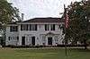
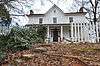
Bona Allen House |
|
000000001983-09-01-0000September 1, 1983
(#83000231) |
395 Main St.
34°07′25″N 84°00′01″W / 34.123611°N 84.000278°W / 34.123611; -84.000278 (Bona Allen House) |
Buford |
|
| 4 |
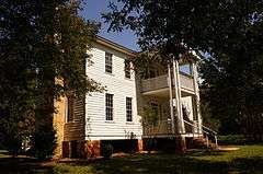
John Quincy Allen House |
|
000000001984-01-12-0000January 12, 1984
(#84001109) |
345 E. Main St.
34°07′21″N 84°00′04″W / 34.1225°N 84.001111°W / 34.1225; -84.001111 (John Quincy Allen House) |
Buford |
|
| 5 |
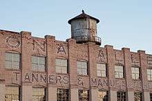
Bona Allen Shoe and Horse Collar Factory |
|
000000002005-01-03-0000January 3, 2005
(#04001138) |
554 W. Main St.
34°06′50″N 84°00′43″W / 34.113889°N 84.011944°W / 34.113889; -84.011944 (Bona Allen Shoe and Horse Collar Factory) |
Buford |
|
| 6 |
Buford Public School Auditorium |
Upload image |
000000002009-08-05-0000August 5, 2009
(#09000586) |
4975 Little Mill Rd.
34°07′10″N 84°00′38″W / 34.119467°N 84.010433°W / 34.119467; -84.010433 (Buford Public School Auditorium) |
Buford |
|
| 7 |
Robert Craig Plantation |
Upload image |
000000001990-06-08-0000June 8, 1990
(#90000805) |
1504 Five Forks Trickum Rd.
33°54′24″N 84°00′59″W / 33.906667°N 84.016389°W / 33.906667; -84.016389 (Robert Craig Plantation) |
Lawrenceville |
|
| 8 |
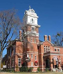
Gwinnett County Courthouse |
|
000000001980-09-18-0000September 18, 1980
(#80001084) |
Courthouse Sq.
33°57′24″N 83°59′21″W / 33.956667°N 83.989167°W / 33.956667; -83.989167 (Gwinnett County Courthouse) |
Lawrenceville |
|
| 9 |
Hudson-Nash House and Cemetery |
Upload image |
000000001990-01-04-0000January 4, 1990
(#89002264) |
3490 Five Forks Trickum Rd.
33°52′29″N 84°04′21″W / 33.874722°N 84.0725°W / 33.874722; -84.0725 (Hudson-Nash House and Cemetery) |
Lilburn |
|
| 10 |
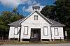
Mechanicsville School |
|
000000001980-10-16-0000October 16, 1980
(#80001085) |
3rd St. and Florida Ave.
33°55′43″N 84°14′50″W / 33.928611°N 84.247222°W / 33.928611; -84.247222 (Mechanicsville School) |
Norcross |
|
| 11 |
Norcross Historic District |
Upload image |
000000001980-11-21-0000November 21, 1980
(#80001086) |
Off U.S. 23
33°56′33″N 84°12′44″W / 33.9425°N 84.212222°W / 33.9425; -84.212222 (Norcross Historic District) |
Norcross |
|
| 12 |
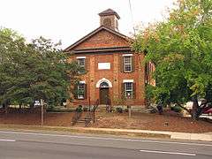
Old Seminary Building |
|
000000001970-12-29-0000December 29, 1970
(#70000206) |
455 Perry St.
33°57′09″N 83°59′20″W / 33.9525°N 83.9890°W / 33.9525; -83.9890 (Old Seminary Building) |
Lawrenceville |
|
| 13 |
Parks-Strickland Archeological Complex |
Upload image |
000000001989-12-08-0000December 8, 1989
(#89002034) |
Address Restricted
|
Dacula |
|
| 14 |
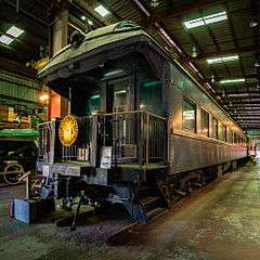
The Superb |
|
000000001999-03-09-0000March 9, 1999
(#98001560) |
3595 S. Old Peachtree Rd.
33°59′19″N 84°09′20″W / 33.988611°N 84.155556°W / 33.988611; -84.155556 (The Superb) |
Duluth |
Railroad car that was used by U.S. President Harding
|
| 15 |
Suwanee Historic District |
Upload image |
000000002013-12-24-0000December 24, 2013
(#13000966) |
Main, Russell & White Sts., Stonecypher & Scales Rds., N & S Railroad
34°03′10″N 84°04′27″W / 34.052819°N 84.074228°W / 34.052819; -84.074228 (Suwanee Historic District) |
Suwanee |
|
| 16 |
William Terrell Homeplace |
Upload image |
000000001982-08-26-0000August 26, 1982
(#82002423) |
E of Lawrenceville off US 29
33°57′59″N 83°57′58″W / 33.966389°N 83.966111°W / 33.966389; -83.966111 (William Terrell Homeplace) |
Lawrenceville |
|
| 17 |
Clarence R. Ware House |
Upload image |
000000001982-06-17-0000June 17, 1982
(#82002424) |
293 N. Perry St.
33°57′30″N 83°59′25″W / 33.958333°N 83.990278°W / 33.958333; -83.990278 (Clarence R. Ware House) |
Lawrenceville |
|
| 18 |
Elisha Winn House |
|
000000001979-12-18-0000December 18, 1979
(#79000728) |
N of Dacula at 908 Dacula Rd.
34°01′25″N 83°54′29″W / 34.023611°N 83.908056°W / 34.023611; -83.908056 (Elisha Winn House) |
Dacula |
|
| 19 |
Thomas Wynne House |
|
000000001977-07-08-0000July 8, 1977
(#77000436) |
N of Lilburn on U.S. 29
33°53′57″N 84°08′17″W / 33.899167°N 84.138056°W / 33.899167; -84.138056 (Thomas Wynne House) |
Lilburn |
|