| [3] |
Name on the Register[4] |
Image |
Date listed[5] |
Location |
City or town |
Description |
|---|
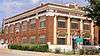
| 1 |
J. P. Astin House |
|
000000001986-09-24-0000September 24, 1986
(#86002390) |
111 E. Campbell
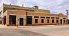
32°56′56″N 99°48′06″W / 32.948889°N 99.801667°W / 32.948889; -99.801667 (J. P. Astin House) |
Stamford |
|
| 2 |
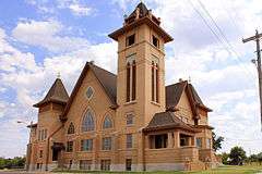
Buena Vista Hotel |
|
000000001986-09-24-0000September 24, 1986
(#86002369) |
123 N. Wetherbee
32°56′47″N 99°48′07″W / 32.94626°N 99.80193°W / 32.94626; -99.80193 (Buena Vista Hotel) |
Stamford |
|
| 3 |
Dr. E. P. Bunkley House and Garage |
|
000000001986-09-24-0000September 24, 1986
(#86002380) |
1034 E. Reynolds
32°56′25″N 99°47′12″W / 32.940278°N 99.786667°W / 32.940278; -99.786667 (Dr. E. P. Bunkley House and Garage) |
Stamford |
|
| 4 |
First Baptist Church |
|
000000001986-09-24-0000September 24, 1986
(#86002359) |
E. Oliver and N. Swenson
32°56′50″N 99°48′08″W / 32.947222°N 99.802222°W / 32.947222; -99.802222 (First Baptist Church) |
Stamford |
|
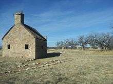
| 5 |
Fort Phantom Hill |
|
000000001972-09-14-0000September 14, 1972
(#72001367) |
N of Abilene on Ranch Rd. 600
32°38′38″N 99°40′41″W / 32.643889°N 99.678056°W / 32.643889; -99.678056 (Fort Phantom Hill) |
Abilene |
|
| 6 |
House at 501 North Swenson |
|
000000001986-09-24-0000September 24, 1986
(#86002374) |
501 N. Swenson
32°57′01″N 99°48′12″W / 32.950278°N 99.803333°W / 32.950278; -99.803333 (House at 501 North Swenson) |
Stamford |
|
| 7 |
House at 502 South Orient |
|
000000001986-09-24-0000September 24, 1986
(#86002377) |
502 S. Orient
32°56′25″N 99°47′41″W / 32.940278°N 99.794722°W / 32.940278; -99.794722 (House at 502 South Orient) |
Stamford |
|
| 8 |
House at 610 East Oliver |
|
000000001986-09-24-0000September 24, 1986
(#86002394) |
610 E. Oliver
32°56′50″N 99°47′43″W / 32.947222°N 99.795278°W / 32.947222; -99.795278 (House at 610 East Oliver) |
Stamford |
|
| 9 |
House at 709 East Reynolds |
|
000000001986-09-24-0000September 24, 1986
(#86002384) |
709 E. Reynolds
32°56′28″N 99°47′37″W / 32.941111°N 99.793611°W / 32.941111; -99.793611 (House at 709 East Reynolds) |
Stamford |
|
| 10 |
House at 719 East Reynolds |
|
000000001986-09-24-0000September 24, 1986
(#86002385) |
719 E. Reynolds
32°56′28″N 99°47′35″W / 32.941111°N 99.793056°W / 32.941111; -99.793056 (House at 719 East Reynolds) |
Stamford |
|
| 11 |
House at 815 East Campbell |
Upload image |
000000001986-09-24-0000September 24, 1986
(#86002392) |
815 E. Campbell
32°56′56″N 99°47′28″W / 32.948889°N 99.791111°W / 32.948889; -99.791111 (House at 815 East Campbell) |
Stamford |
|
| 12 |
A. J. Jackson House |
Upload image |
000000001986-09-24-0000September 24, 1986
(#86002366) |
305 S. Ferguson
32°56′33″N 99°48′02″W / 32.94253°N 99.80060°W / 32.94253; -99.80060 (A. J. Jackson House) |
Stamford |
|
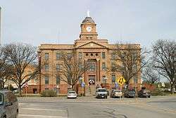
| 13 |
Jones County Courthouse |
|
000000002003-05-01-0000May 1, 2003
(#03000330) |
1100 12th St.
32°45′23″N 99°53′47″W / 32.756389°N 99.896389°W / 32.756389; -99.896389 (Jones County Courthouse) |
Anson |
|
| 14 |
Old Bryant-Link Building |
|
000000001986-09-24-0000September 24, 1986
(#86002361) |
120 S. Swenson
32°56′41″N 99°48′11″W / 32.944722°N 99.803056°W / 32.944722; -99.803056 (Old Bryant-Link Building) |
Stamford |
|
| 15 |
Old Penick-Hughes Company |
|
000000001986-09-24-0000September 24, 1986
(#86002354) |
100-106 E. Hamilton
32°56′38″N 99°48′09″W / 32.943889°N 99.8025°W / 32.943889; -99.8025 (Old Penick-Hughes Company) |
Stamford |
|
| 16 |
Old West Texas Utilities Company |
|
000000001986-09-24-0000September 24, 1986
(#86002335) |
127 E. McHarg
32°56′44″N 99°48′06″W / 32.945556°N 99.801667°W / 32.945556; -99.801667 (Old West Texas Utilities Company) |
Stamford |
|
| 17 |
Old H. O. Wooten Grocery |
Upload image |
000000001986-09-24-0000September 24, 1986
(#86002363) |
128 E. Rotan
32°56′34″N 99°48′06″W / 32.942778°N 99.801667°W / 32.942778; -99.801667 (Old H. O. Wooten Grocery) |
Stamford |
Demolished
|
| 18 |
Saint John's Methodist Church |
|
000000001986-09-24-0000September 24, 1986
(#86002351) |
S. Ferguson St.
32°56′38″N 99°47′59″W / 32.943889°N 99.799722°W / 32.943889; -99.799722 (Saint John's Methodist Church) |
Stamford |
|
| 19 |
SMS Building |
|
000000001986-09-24-0000September 24, 1986
(#86002336) |
101 S. Wetherbee and 210 E. McHarg
32°56′42″N 99°48′05″W / 32.945°N 99.801389°W / 32.945; -99.801389 (SMS Building) |
Stamford |
|
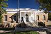
| 20 |
Stamford City Hall |
|
000000001986-09-24-0000September 24, 1986
(#86002348) |
201 E. McHarg
32°56′44″N 99°48′05″W / 32.94551°N 99.80150°W / 32.94551; -99.80150 (Stamford City Hall) |
Stamford |
|
| 21 |
A. J. Swenson House |
Upload image |
000000001986-09-24-0000September 24, 1986
(#86002395) |
305 E. Oliver
32°56′52″N 99°47′48″W / 32.947778°N 99.796667°W / 32.947778; -99.796667 (A. J. Swenson House) |
Stamford |
Demolished
|
| 22 |
US Post Office |
|
000000001986-09-24-0000September 24, 1986
(#86002332) |
115 S. Swenson St.[6]
32°56′41″N 99°48′08″W / 32.944722°N 99.802222°W / 32.944722; -99.802222 (US Post Office) |
Stamford |
|


.jpg)

.jpg)
.jpg)
.jpg)
.jpg)
.jpg)
.jpg)
.jpg)
.jpg)