National Register of Historic Places listings in Lamar County, Texas
List of Registered Historic Places in Lamar County, Texas
This is intended to be a complete list of properties and districts listed on the National Register of Historic Places in Lamar County, Texas. The locations of National Register properties and districts (at least for all showing latitude and longitude coordinates below) may be seen in a map by clicking on "Map of all coordinates".[1]
- This National Park Service list is complete through NPS recent listings posted December 2, 2016.[2]
| [3] | Name on the Register[4] | Image | Date listed[5] | Location | City or town | Description |
|---|---|---|---|---|---|---|
| 1 | Atkinson-Morris House | Upload image | (#88001914) |
802 Fitzhugh 33°40′07″N 95°32′49″W / 33.668523°N 95.54701°W |
Paris | |
| 2 | Bailey-Ragland House |  |
(#88001917) |
433 W. Washington 33°39′15″N 95°33′39″W / 33.65414°N 95.560929°W |
Paris | |
| 3 | Benjamin and Adelaide Baldwin House | Upload image | (#88001925) |
714 Graham 33°39′50″N 95°33′48″W / 33.663859°N 95.56336°W |
Paris | |
| 4 | Baty-Plummer House |  |
(#88001931) |
708 Sherman 33°39′27″N 95°33′48″W / 33.657562°N 95.563263°W |
Paris | |
| 5 | Thomas and Bettie Brazelton House |  |
(#88001932) |
801 W. Sherman 33°39′26″N 95°33′50″W / 33.657174°N 95.563880°W |
Paris | |
| 6 | Carlton-Gladden House |  |
(#88001933) |
2120 Bonham 33°39′39″N 95°34′15″W / 33.660967°N 95.570941°W |
Paris | |
| 7 | Church Street Historic District | Upload image | (#88001936) |
Roughly bounded by E. Austin, 3rd, SE, Washington and 1st, SW Sts. 33°39′25″N 95°33′19″W / 33.656964°N 95.555332°W |
Paris | |
| 8 | J. M. and Emily Daniel House |  |
(#88001921) |
216 4th Street SW 33°39′34″N 95°33′38″W / 33.659549°N 95.560583°W |
Paris | |
| 9 | Ellis II Site | Upload image | (#78002967) |
Address Restricted |
Pin Hook | |
| 10 | Emerson Site | Upload image | (#78002968) |
Address Restricted |
Pin Hook | |
| 11 | First Church of Christ, Scientist |  |
(#88001912) |
339 W. Kaufman 33°39′35″N 95°33′36″W / 33.659615°N 95.559863°W |
Paris | |
| 12 | First Presbyterian Church | 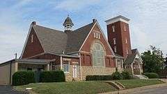 |
(#88001913) |
410 W. Kaufman 33°39′36″N 95°33′37″W / 33.660025°N 95.560401°W |
Paris | |
| 13 | First United Methodist Church | .jpg) |
(#83003146) |
322 Lamar St. 33°39′40″N 95°33′12″W / 33.661111°N 95.553333°W |
Paris | |
| 14 | John Chisum Gibbons House | 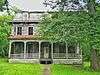 |
(#88001923) |
623 6th Street SE 33°39′21″N 95°33′00″W / 33.655947°N 95.549901°W |
Paris | |
| 15 | High House | Upload image | (#88001920) |
352 West Washington 33°39′16″N 95°33′36″W / 33.654539°N 95.560035°W |
Paris | |
| 16 | House at 705 3rd Street, SE | Upload image | (#88001935) |
705 3rd St., SE 33°39′19″N 95°33′13″W / 33.655164°N 95.553501°W |
Paris | |
| 17 | Edwin and Mary Jenkins House | Upload image | (#88001927) |
549 5th, NW 33°39′58″N 95°33′40″W / 33.666167°N 95.560982°W |
Paris | |
| 18 | Johnson-McCuistion House | Upload image | (#88001911) |
730 Clarksville 33°39′36″N 95°32′56″W / 33.660114°N 95.548879°W |
Paris | |
| 19 | Lamar County Hospital |  |
(#88001918) |
625 W. Washington 33°39′14″N 95°33′45″W / 33.653895°N 95.562449°W |
Paris | |
| 20 | William and Etta Latimer House | Upload image | (#88001930) |
707 Sherman 33°39′26″N 95°33′48″W / 33.657086°N 95.563302°W |
Paris | |
| 21 | Loma Alto Site | Upload image | (#78002969) |
Address Restricted |
Pin Hook | |
| 22 | A. C. Mackin Archeological Site | Upload image | (#74002085) |
Address Restricted |
Faulkner | |
| 23 | Samuel Bell Maxey House | .jpg) |
(#71000943) |
812 E. Church St. 33°39′14″N 95°33′17″W / 33.653889°N 95.554722°W |
Paris | |
| 24 | McCormic-Bishop House | Upload image | (#88001910) |
603 8th St., SE 33°39′22″N 95°32′53″W / 33.65623°N 95.54794°W |
Paris | |
| 25 | Means-Justiss House | Upload image | (#88001934) |
537 6th St., SE 33°39′24″N 95°33′01″W / 33.65664°N 95.55021°W |
Paris | |
| 26 | Morris-Moore House | Upload image | (#88001926) |
744 3rd St, NW 33°40′05″N 95°33′32″W / 33.668056°N 95.558889°W |
Paris | |
| 27 | Paris Commercial Historic District | Upload image | (#88001937) |
Roughly bounded by Price, 3rd, SE, Sherman and 4th, SW 33°39′40″N 95°33′24″W / 33.660999°N 95.556746°W |
Paris | |
| 28 | Pine Bluff-Fitzhugh Historic District | Upload image | (#88001938) |
500-900 blks of Pine Bluff and 300-600 blks of Fitzhugh 33°39′50″N 95°32′51″W / 33.663971°N 95.547561°W |
Paris | |
| 29 | Thaddeus and Josepha Preston House | Upload image | (#88001915) |
731 E. Austin 33°39′32″N 95°32′56″W / 33.658837°N 95.548790°W |
Paris | |
| 30 | Ragland House |  |
(#88001922) |
208 5th St., SW 33°39′35″N 95°33′41″W / 33.659621°N 95.561505°W |
Paris | |
| 31 | Rodgers-Wade Furniture Company |  |
(#88001919) |
401 3rd Street SW 33°39′29″N 95°33′31″W / 33.657957°N 95.558691°W |
Paris | |
| 32 | Santa Fe-Frisco Depot |  |
(#88001939) |
1100 W. Kaufman 33°39′35″N 95°34′01″W / 33.659766°N 95.567035°W |
Paris | |
| 33 | Scott-Roden Mansion |  |
(#83003147) |
425 S. Church St. 33°39′27″N 95°33′15″W / 33.6575°N 95.554167°W |
Paris | |
| 34 | St. Paul's Baptist Church | 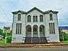 |
(#88001928) |
454 2nd, NE 33°39′58″N 95°33′15″W / 33.666107°N 95.554296°W |
Paris | |
| 35 | State Highway 5 Bridge at High Creek | Upload image | (#96001102) |
FM 1509, 1.8 mi (2.9 km). W of jct. with FM 38 33°36′43″N 95°44′50″W / 33.611944°N 95.747222°W |
Brookston | Warren pony truss bridge built in 1920. Deck replaced with wood in 1935. Entire bridge removed and replaced in 2001.[6] |
| 36 | State Highway Bridge 5 at Big Pine Creek | Upload image | (#96001103) |
FM 1510, 1.4 mi (2.3 km). E of jct. with FM 38 33°39′39″N 95°40′23″W / 33.660833°N 95.673056°W |
Brookston | Warren pony truss bridge built in 1920. Deck replaced with wood in 1935. Entire bridge removed in 2001.[7] |
| 37 | Swindle Site | Upload image | (#78002970) |
Address Restricted |
Pin Hook | |
| 38 | W. S. and Mary Trigg House |  |
(#88001924) |
441 12th St., SE 33°39′26″N 95°32′37″W / 33.657129°N 95.543516°W |
Paris | |
| 39 | Wise-Fielding House and Carriage House |  |
(#88001916) |
418 W. Washington 33°39′17″N 95°33′39″W / 33.654744°N 95.560881°W |
Paris | |
| 40 | Edgar and Annie Wright House |  |
(#88001929) |
857 Lamar 33°39′41″N 95°32′50″W / 33.661518°N 95.547231°W |
Paris |
See also
| Wikimedia Commons has media related to National Register of Historic Places in Lamar County, Texas. |
References
- ↑ The latitude and longitude information provided in this table was derived originally from the National Register Information System, which has been found to be fairly accurate for about 99% of listings. For about 1% of NRIS original coordinates, experience has shown that one or both coordinates are typos or otherwise extremely far off; some corrections may have been made. A more subtle problem causes many locations to be off by up to 150 yards, depending on location in the country: most NRIS coordinates were derived from tracing out latitude and longitudes off of USGS topographical quadrant maps created under the North American Datum of 1927, which differs from the current, highly accurate WGS84 GPS system used by most on-line maps. Chicago is about right, but NRIS longitudes in Washington are higher by about 4.5 seconds, and are lower by about 2.0 seconds in Maine. Latitudes differ by about 1.0 second in Florida. Some locations in this table may have been corrected to current GPS standards.
- ↑ "National Register of Historic Places: Weekly List Actions". National Park Service, United States Department of the Interior. Retrieved on December 2, 2016.
- ↑ Numbers represent an ordering by significant words. Various colorings, defined here, differentiate National Historic Landmarks and historic districts from other NRHP buildings, structures, sites or objects.
- ↑ National Park Service (2008-04-24). "National Register Information System". National Register of Historic Places. National Park Service.
- ↑ The eight-digit number below each date is the number assigned to each location in the National Register Information System database, which can be viewed by clicking the number.
- ↑ National Bridge Inventory
- ↑ National Bridge Inventory
| Topics | |
|---|---|
| Lists by states |
|
| Lists by insular areas | |
| Lists by associated states | |
| Other areas | |
| |
This article is issued from Wikipedia - version of the 7/3/2016. The text is available under the Creative Commons Attribution/Share Alike but additional terms may apply for the media files.